
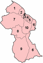
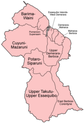
Regions of Guyana by number and name
Guyana is divided into 10 regions:[1][2]
| No. | Region | Area (km2) |
Pop. (2012) |
Pop. per km2 |
Capital |
|---|---|---|---|---|---|
| 1 | Barima-Waini | 20,339 | 26,941 | 1.3 | Mabaruma |
| 2 | Pomeroon-Supenaam | 6,195 | 46,810 | 7.6 | Anna Regina |
| 3 | Essequibo Islands-West Demerara | 3,755 | 107,416 | 28.6 | Vreed en Hoop |
| 4 | Demerara-Mahaica | 2,232 | 313,429 | 140.4 | Triumph[3][4] |
| 5 | Mahaica-Berbice | 4,190 | 49,723 | 11.9 | Fort Wellington |
| 6 | East Berbice-Corentyne | 36,234 | 109,431 | 3.0 | New Amsterdam |
| 7 | Cuyuni-Mazaruni | 47,213 | 20,280 | 0.4 | Bartica |
| 8 | Potaro-Siparuni | 20,051 | 10,190 | 0.5 | Mahdia |
| 9 | Upper Takutu-Upper Essequibo | 57,750 | 24,212 | 0.4 | Lethem |
| 10 | Upper Demerara-Berbice | 17,040 | 39,452 | 2.3 | Linden |
| Guyana | 214,999 | 747,884 | 3.5 | Georgetown |
Each Region is administered by a Regional Democratic Council (RDC) which is headed by a Chairman. The Regions are divided into neighbourhood councils, known as Neighbourhood Democratic Councils (NDCs).[5]
The current regional structure was established by the Local Democratic Organs Act in 1980. The hyphenated names indicate the name of the rivers that define their border.[6]
YouTube Encyclopedic
-
1/3Views:2 14113 423574 174
-
Administrative Regions of Guyana-Part 2
-
7 Facts about Guyana
-
French Overseas Regions and Territories Explained
Transcription
Historical divisions
Previous regional names:[7][8]
Regions of Guyana (1971)
- East Berbice-Corentyne
- East Demerara-West Coast Berbice
- Mazaruni Potaro
- North West
- Rupununi
- West Demerara-Essequibo Coast
Regions of British Guiana (1958)
- East Berbice
- Essequibo
- Essequibo Islands
- North west (hinterlands)
- Mazaruni-Potaro (hinterlands)
- Rupununi (hinterlands)
Colonial counties (before 1958)
See also
- ISO 3166-2:GY
- List of Caribbean First-level Subdivisions by Total Area
- List of Guyanese regions by Human Development Index
References
- ^ Bureau of Statistics - Guyana Archived 2012-02-17 at the Wayback Machine, CHAPTER III: POPULATION REDISTRIBUTION AND INTERNAL MIGRATION, Table 3.4: Population Density, Guyana: 1980 - 2002
- ^ Guyana - Government Information Agency Archived 2007-08-14 at the Wayback Machine, National Profile
- ^ "Region Four RDC office moves to Triumph". Stabroek News. Retrieved 18 August 2020.
- ^ "Regional Democratic Council Region No. 4 - Demerara/Mahaica, Guyana". Regional Democratic Council Region No. 4via Facebook. Retrieved 18 August 2020.
- ^ Government of Guyana, Statistics
- ^ "THE LOCAL DEMOCRATIC ORGANS ACT 1980" (PDF). parliament.gov.g. 7 October 1980. Retrieved 2020-01-03.
- ^ "Internal Administrative Divisions of British Guiana" (PDF). Cia.gov. 29 August 1958. Archived from the original (PDF) on January 22, 2017. Retrieved 2020-01-03.
- ^ "ADMIN REGIONS DETAILED – GUYANA LANDS AND SURVEYS COMMISSION'S FACT PAGE ON GUYANA". Retrieved 2021-03-16.
External links
- "Regions of Guyana". Statoids.
Administrative divisions of the Americas | ||
|---|---|---|
| ||
|  | |
| Sovereign states |
| |
| ||