
Abitibi | |
|---|---|
 | |
| Coordinates: 48°34′N 78°00′W / 48.567°N 78.000°W[1] | |
| Country | |
| Province | |
| Region | Abitibi-Témiscamingue |
| Effective | January 1, 1983 |
| County seat | Amos |
| Government | |
| • Type | Prefecture |
| • Prefect | Jacques Riopel |
| Area | |
| • Total | 7,862.70 km2 (3,035.81 sq mi) |
| • Land | 7,677.01 km2 (2,964.11 sq mi) |
| Population (2016)[3] | |
| • Total | 24,639 |
| • Density | 3.2/km2 (8/sq mi) |
| • Change 2011-2016 | |
| • Dwellings | 11,374 |
| Time zone | UTC−5 (EST) |
| • Summer (DST) | UTC−4 (EDT) |
| Area code | 819 |
| Website | www |
| [4] | |
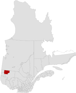
Abitibi Regional County Municipality is a regional county municipality in the Abitibi-Témiscamingue region of Quebec. The seat is Amos.[2]
YouTube Encyclopedic
-
1/2Views:5563 979
-
VIA#606 The Abitibi Departing Senneterre, PQ Jun 14 2015
-
lac duparquet quebec abitibi
Transcription
Subdivisions
There are 19 subdivisions within the RCM:[2]
|
|
|
|
|
|
Demographics
Population
Canada census – Abitibi community profile
| 2021 | 2016 | 2011 | |
|---|---|---|---|
| Population | 24,764 (+0.5% from 2016) | 24,639 (+1.2% from 2011) | 24,354 (+0.3% from 2006) |
| Land area | 7,627.63 km2 (2,945.04 sq mi) | 7,679.36 km2 (2,965.02 sq mi) | 7,677.01 km2 (2,964.11 sq mi) |
| Population density | 3.2/km2 (8.3/sq mi) | 3.2/km2 (8.3/sq mi) | 3.2/km2 (8.3/sq mi) |
| Median age | 44 (M: 43.2, F: 44.4) | 43.0 (M: 42.4, F: 43.7) | 42.2 (M: 41.7, F: 42.7) |
| Private dwellings | 11,784 (total) 10,941 (occupied) | 11,374 (total) | 11,109 (total) |
| Median household income | $76,000 | $64,064 | $54,465 |
|
| ||||||||||||||||||||||||
| [10][3] | |||||||||||||||||||||||||
Language
| Canada Census Mother Tongue - Abitibi Regional County Municipality, Quebec[10] | ||||||||||||||||||
|---|---|---|---|---|---|---|---|---|---|---|---|---|---|---|---|---|---|---|
| Census | Total | French
|
English
|
French & English
|
Other
| |||||||||||||
| Year | Responses | Count | Trend | Pop % | Count | Trend | Pop % | Count | Trend | Pop % | Count | Trend | Pop % | |||||
2016
|
24,400
|
23,690 | 97.09% | 235 | 0.96% | 70 | 0.29% | 405 | 1.66% | |||||||||
2011
|
24,020
|
23,360 | 97.25% | 215 | 0.90% | 70 | 0.29% | 375 | 1.56% | |||||||||
2006
|
23,915
|
23,170 | 96.88% | 345 | 1.44% | 15 | 0.07% | 385 | 1.61% | |||||||||
2001
|
24,275
|
23,620 | 97.30% | 225 | 0.93% | 60 | 0.25% | 370 | 1.52% | |||||||||
1996
|
25,050
|
24,435 | n/a | 97.54% | 245 | n/a | 0.98% | 50 | n/a | 0.20% | 320 | n/a | 1.28% | |||||
Transportation
Access Routes
Highways and numbered routes that run through the municipality, including external routes that start or finish at the county border:[11]
|
|
Protected areas
Attractions and other areas
- Alphonse-Normadin Covered Bridge [1950] (Saint-Dominique-du-Rosaire)
- Amos Airport (Trecesson)
- Exposition de la Maison de la culture Centre (Amos)
- Garde Dispensary (La Corne)
- Grazie Gadens (La Motte)
- l'Arche-de-Noe Covered Bridge [1937] (La Morandière-Rochebaucourt)
- l'Harricana Ferme d'autruches Slope (Saint-Mathieu-d'Harricana)
- l'Original Covered Bridge [1942] (La Morandière-Rochebaucourt)
- Mont-Video (Barraute)
- Pageau Refuge (Amos)
- Poste Museum (Saint-Marc-de-Figuery)
See also
References
- ^ "Banque de noms de lieux du Québec: Reference number 141126". toponymie.gouv.qc.ca (in French). Commission de toponymie du Québec.
- ^ a b c d "Répertoire des municipalités: Geographic code 880". www.mamh.gouv.qc.ca (in French). Ministère des Affaires municipales et de l'Habitation.
- ^ a b c "Census Profile, 2016 Census: Abitibi, Municipalité régionale de comté [Census division], Quebec". Statistics Canada. Retrieved December 2, 2019.
- ^ "Abitibi Regional County Municipality (Code 2488) Census Profile". 2011 census. Government of Canada - Statistics Canada.
- ^ "2021 Community Profiles". 2021 Canadian Census. Statistics Canada. February 4, 2022. Retrieved 2023-10-19.
- ^ "2016 Community Profiles". 2016 Canadian Census. Statistics Canada. August 12, 2021. Retrieved 2019-12-02.
- ^ "2011 Community Profiles". 2011 Canadian Census. Statistics Canada. March 21, 2019. Retrieved 2014-02-18.
- ^ "2006 Community Profiles". 2006 Canadian Census. Statistics Canada. August 20, 2019.
- ^ "2001 Community Profiles". 2001 Canadian Census. Statistics Canada. July 18, 2021.
- ^ a b Statistics Canada: 1996, 2001, 2006, 2011 census
- ^ Official Transport Quebec Road Map
Adjacent Counties & Equivalent Territories | |
|---|---|
| Regional county municipalities and equivalent territories | |
|---|---|
| Municipalities | |
| International | |
|---|---|
| National | |
| Geographic | |
| Other | |