To install click the Add extension button. That's it.

The source code for the WIKI 2 extension is being checked by specialists of the Mozilla Foundation, Google, and Apple. You could also do it yourself at any point in time.

4,5
Kelly Slayton
Congratulations on this excellent venture… what a great idea!
Alexander Grigorievskiy
I use WIKI 2 every day and almost forgot how the original Wikipedia looks like.
Live Statistics
English Articles
Improved in 24 Hours
Added in 24 Hours
What we do. Every page goes through several hundred of perfecting techniques; in live mode. Quite the same Wikipedia. Just better.
.
Leo
Newton
Brights
Milds

A4 motorway (Belgium)

From Wikipedia, the free encyclopedia

A4
Dutch: Autosnelweg 4
French: Autoroute 4
Route information
Part of E411
Length188 km (117 mi)
Location
CountryBelgium
Highway system
  • Highways of Belgium

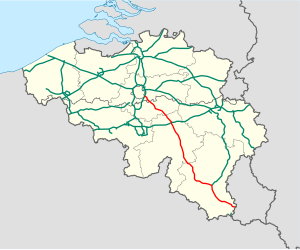
The A4 is a Belgian motorway connecting Brussels and the A6 in Luxembourg.[1] The motorway is part of E411 between Brussels and Arlon. This motorway, the longest of Belgium (188km), is also nicknamed the "Autoroute de la Nouvelle Belgique" as opposed to the structuring axis Liège-Tournai (crossing an aging industrial zone). Indeed, the A4 connects rapidly developing centers such as Brussels and the city of Luxembourg, and it crosses economic zones full of vitality: the south-eastern suburbs of Brussels, Walloon Brabant and in particular Ottignies-Louvain-la-Neuve, Namur the new capital of Wallonia since 1986,[2] and the country of Arlon.[3]

A4 close to Transinne
Bridge of Custinne

YouTube Encyclopedic

  • 1/3
    Views:
    438
    331
    40 561
  • [Roadtrip - Luxembourg & Belgium] A6 - A4 - R0: Strassen to Brussels (1/2)
  • [Roadtrip - Luxembourg & Belgium] A6 - A4 - R0: Strassen to Brussels (2/2)
  • A4 Rotterdam - Amsterdam (extended)

Transcription

See also

References

  1. ^ "Réseau structurant".
  2. ^ "11 décembre 1986 : Namur, capitale de la Région wallonne, siège du Conseil régional wallon | Connaître la Wallonie".
  3. ^ "Atlas des dynamiques territoriales" (PDF).


50°12′44″N 5°03′56″E / 50.212199°N 5.065549°E / 50.212199; 5.065549


This page was last edited on 17 August 2021, at 18:52
Basis of this page is in Wikipedia. Text is available under the CC BY-SA 3.0 Unported License. Non-text media are available under their specified licenses. Wikipedia® is a registered trademark of the Wikimedia Foundation, Inc. WIKI 2 is an independent company and has no affiliation with Wikimedia Foundation.