

The A479, officially also known as the Glanusk Park (Crickhowell)—Llyswen Trunk Road, is a trunk road in Wales. It connects Crickhowell to Llyswen via the Rhiangoll valley and Talgarth, running through the Brecon Beacons National Park.
YouTube Encyclopedic
-
1/2Views:58844 180
-
exploring
-
KARNAUGH MAP | SIMPLIFY THE BOOLEAN FUNCTION USING K MAP | K MAP | KARNAUP MAP WITH DONT CARE METHOD
Transcription
Route
The road starts at Glanusk Park near Crickhowell and runs roughly in a northerly direction to Llyswen, where it joins the A470 road. It runs entirely within the county of Powys and is a single carriageway throughout its length.[1] From Crickhowell to Talgarth, the road is in the Brecon Beacons National Park, and follows the Rhiangoll valley.[2][3] The southern end is near Tretower Castle and Court.[4]
History

The A479 originally ran through Builth Wells to Rhayader. This part of the road is now the A470.[5][6] A short section of road near Llyswen was realigned in 1995.[7]
A bypass of Talgarth and Bronllys began construction in 2006. Part of the Talgarth bypass runs on the former Mid-Wales Railway. Because this part of the road runs through the Brecon Beacons, additional treatment was needed to minimise disruption with the nearby countryside. This included a specific alignment of the highway, and replanting of hedgerows to fit in with the existing parts of the road. The bypass opened in 2009.[2]
Traffic
In 2005, the A479 was listed as one of the most dangerous roads in Wales in an AA Motorway Trust report.[8] In 2013, another report suggested the same.[9]
The section of the A479 between Pengenffordd and Talgarth has had regular issues with subsidence. A section south of Talgarth was closed in March 2016.[10] In February 2017, the road was closed for an extended period in order to lay new foundation work.[11] In February 2020, a section of the road near Talgarth was closed following a collapse during Storm Dennis. The damage affected the surface and foundation of the road, resulting it being closed until November.[12][13]
See also
References
- ^ "The A479 Trunk Road (Glanusk Park to Llyswen, Powys) (Temporary Speed Restrictions and No Overtaking) Order 2016" (PDF). Legislation.gov.uk. Retrieved 9 March 2016.
- ^ a b "A479 Talgarth Relief Road and Bronllys Bypass". CEEqual. March 2009. Retrieved 17 August 2020.
- ^ "FINAL PROPOSALS Community No. B16 - LLANFIHANGEL CWMDU WITH BWLCH AND CATHEDINE" (PDF). Retrieved 6 November 2021.
- ^ "Tretower Castle". Brecon Beacons National Park. Retrieved 17 August 2020.
- ^ Montgomery and Llandrindod Wells (Map). Ordnance Survey 7th Series. 1961. Retrieved 17 August 2020.
- ^ "A road to love for". Institute of Welsh Affairs. 26 March 2010. Retrieved 17 August 2020.
- ^ "The Glanusk Park (Crickhowell)-Llyswen Trunk Road (A479) (Dderw Improvement) Order 1995". Department for Transport (England and Wales). 8 September 1995. Retrieved 17 August 2020.
- ^ "Survey lists Welsh danger roads". BBC News. 9 March 2005. Archived from the original on 16 September 2020. Retrieved 17 August 2020.
- ^ "Revealed: Wales' most dangerous roads". Wales Online. 24 October 2013. Retrieved 17 August 2020.
- ^ "The A479 Trunk Road (Lower Genffordd Bends & Pengenffordd, South of Talgarth, Powys) (Temporary Prohibition of Vehicles) Order 2016" (PDF). Traffic Wales. 8 March 2016. Retrieved 19 August 2020.
- ^ "A479 Talgarth - Pengenffordd - Crickhowell - What's really going on?". 7 February 2017. Retrieved 17 August 2020.
- ^ "A479 Lower Genffordd Bends – Road Closure". Traffic Wales. Retrieved 17 August 2020.[permanent dead link]
- ^ "A479 Lower Genffordd Bends near Talgarth - Essential embankment strengthening works - (Current – 11/2020)". Traffic Wales. Archived from the original on 10 August 2020. Retrieved 17 August 2020.
External links
 Media related to A479 road (Wales) at Wikimedia Commons
A roads in Zone 4 of the Great Britain road numbering scheme | ||
|---|---|---|
| ||
| ||
| Managed by the North and Mid Wales Trunk Road Agent |
|
|---|---|
| Managed by the South Wales Trunk Road Agent |
|
| Related topics and further information | |
Transport in Powys | |||||||
|---|---|---|---|---|---|---|---|
| Road | 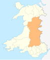 | ||||||
| Footpaths | |||||||
| Cycle routes | |||||||
| Railway stations |
| ||||||