
59 Street | ||||||||||||||||||||||||||||||||||||||||||||||||||||||||||||||||||||||||||||||||||||||||||||||||||||||||||||||
|---|---|---|---|---|---|---|---|---|---|---|---|---|---|---|---|---|---|---|---|---|---|---|---|---|---|---|---|---|---|---|---|---|---|---|---|---|---|---|---|---|---|---|---|---|---|---|---|---|---|---|---|---|---|---|---|---|---|---|---|---|---|---|---|---|---|---|---|---|---|---|---|---|---|---|---|---|---|---|---|---|---|---|---|---|---|---|---|---|---|---|---|---|---|---|---|---|---|---|---|---|---|---|---|---|---|---|---|---|---|---|
 Looking south on the southbound platform. An R160 R train is visible on the southbound local track. | ||||||||||||||||||||||||||||||||||||||||||||||||||||||||||||||||||||||||||||||||||||||||||||||||||||||||||||||
| Station statistics | ||||||||||||||||||||||||||||||||||||||||||||||||||||||||||||||||||||||||||||||||||||||||||||||||||||||||||||||
| Address | 59th Street & Fourth Avenue Brooklyn, NY 11220[1] | |||||||||||||||||||||||||||||||||||||||||||||||||||||||||||||||||||||||||||||||||||||||||||||||||||||||||||||
| Borough | Brooklyn | |||||||||||||||||||||||||||||||||||||||||||||||||||||||||||||||||||||||||||||||||||||||||||||||||||||||||||||
| Locale | Sunset Park | |||||||||||||||||||||||||||||||||||||||||||||||||||||||||||||||||||||||||||||||||||||||||||||||||||||||||||||
| Coordinates | 40°38′29″N 74°01′04″W / 40.64139°N 74.01778°W | |||||||||||||||||||||||||||||||||||||||||||||||||||||||||||||||||||||||||||||||||||||||||||||||||||||||||||||
| Division | B (BMT)[2] | |||||||||||||||||||||||||||||||||||||||||||||||||||||||||||||||||||||||||||||||||||||||||||||||||||||||||||||
| Line | BMT Fourth Avenue Line | |||||||||||||||||||||||||||||||||||||||||||||||||||||||||||||||||||||||||||||||||||||||||||||||||||||||||||||
| Services | N R W | |||||||||||||||||||||||||||||||||||||||||||||||||||||||||||||||||||||||||||||||||||||||||||||||||||||||||||||
| Transit |
| |||||||||||||||||||||||||||||||||||||||||||||||||||||||||||||||||||||||||||||||||||||||||||||||||||||||||||||
| Structure | Underground | |||||||||||||||||||||||||||||||||||||||||||||||||||||||||||||||||||||||||||||||||||||||||||||||||||||||||||||
| Platforms | 2 island platforms cross-platform interchange | |||||||||||||||||||||||||||||||||||||||||||||||||||||||||||||||||||||||||||||||||||||||||||||||||||||||||||||
| Tracks | 4 | |||||||||||||||||||||||||||||||||||||||||||||||||||||||||||||||||||||||||||||||||||||||||||||||||||||||||||||
| Other information | ||||||||||||||||||||||||||||||||||||||||||||||||||||||||||||||||||||||||||||||||||||||||||||||||||||||||||||||
| Opened | June 22, 1915[5] | |||||||||||||||||||||||||||||||||||||||||||||||||||||||||||||||||||||||||||||||||||||||||||||||||||||||||||||
| Accessible | ||||||||||||||||||||||||||||||||||||||||||||||||||||||||||||||||||||||||||||||||||||||||||||||||||||||||||||||
| Opposite- direction transfer | Yes | |||||||||||||||||||||||||||||||||||||||||||||||||||||||||||||||||||||||||||||||||||||||||||||||||||||||||||||
| Traffic | ||||||||||||||||||||||||||||||||||||||||||||||||||||||||||||||||||||||||||||||||||||||||||||||||||||||||||||||
| 2022 | 2,640,485[6] | |||||||||||||||||||||||||||||||||||||||||||||||||||||||||||||||||||||||||||||||||||||||||||||||||||||||||||||
| Rank | 110 out of 423[6] | |||||||||||||||||||||||||||||||||||||||||||||||||||||||||||||||||||||||||||||||||||||||||||||||||||||||||||||
| ||||||||||||||||||||||||||||||||||||||||||||||||||||||||||||||||||||||||||||||||||||||||||||||||||||||||||||||
| ||||||||||||||||||||||||||||||||||||||||||||||||||||||||||||||||||||||||||||||||||||||||||||||||||||||||||||||
| ||||||||||||||||||||||||||||||||||||||||||||||||||||||||||||||||||||||||||||||||||||||||||||||||||||||||||||||
| ||||||||||||||||||||||||||||||||||||||||||||||||||||||||||||||||||||||||||||||||||||||||||||||||||||||||||||||
| ||||||||||||||||||||||||||||||||||||||||||||||||||||||||||||||||||||||||||||||||||||||||||||||||||||||||||||||


The 59th Street station is an express station on the BMT Fourth Avenue Line of the New York City Subway. Located at 59th Street and Fourth Avenue in Sunset Park, Brooklyn, it is served by the N and R trains at all times. During rush hours, several W trains also serve the station.
The 59th Street station was constructed as part of the Fourth Avenue Line, which was approved in 1905. Construction on the segment of the line that includes 59th Street started on March 15, 1913, and was completed in 1915. The station opened on June 22, 1915, as the southernmost station of the initial portion of the BMT Fourth Avenue Line. The station's platforms were lengthened in 1926–1927,[7] and again during the 1960s.[8] Elevator access was added in late 2020, in tandem with a station renovation between 2018 and 2020 to make the station compliant with the Americans with Disabilities Act of 1990.
YouTube Encyclopedic
-
1/5Views:1 49530433486 37741 574
-
R46 R Train at 59th Street
-
59th St - Lexington Ave Subway Station
-
BMT 4th Avenue Line: R160B Alstom and R46 N and R Train Action at 59th St
-
⁴ᴷ⁶⁰ The Ugliest NYC Subway Station (Narrated April 2019): Chambers Street (J)(Z)
-
BMT Subway: R160 (N) and R46 (R) trains at 59th Street (Brooklyn)
Transcription
History
Construction

The 59th Street station was constructed as part of the Fourth Avenue Line, the plan for which was initially adopted on June 1, 1905.[9] The Rapid Transit Commission was succeeded on July 1, 1907, by the New York State Public Service Commission (PSC), which approved the plan for the line in late 1907.[10][11]
As part of negotiations between New York City, the Brooklyn Rapid Transit Company (BRT), and the Interborough Rapid Transit Company for the expansion of the city's transit network, the line was leased to a subsidiary of the BRT. The agreement, known as Contract 4 of the Dual Contracts, was signed on March 19, 1913.[10] In 1912, during the Dual System negotiations, the construction of an extension of the Fourth Avenue subway from 43rd Street to 89th Street, just south of the 86th Street station, was recommended. The proposal was approved by the Board of Estimate on February 15, 1912. The PSC directed its chief engineer to create plans on June 14, 1912. The two contracts for the extension, Route 11B, were awarded on September 16, 1912, to the Degnon Construction Company for a combined $3.8 million (equivalent to $120 million in 2023).[12]
Construction on Route 11B1, the section of the extension between 43rd Street and 61st Street, which includes the 59th Street station, began on March 15, 1913. Originally, this section was planned to have two tracks, but after the connection to the Sea Beach Line was added to the plan during the middle of construction, the plan was changed to four tracks. This section was completed in 1915.[9] 59th Street opened on June 22, 1915, as part of an extension of the subway to Coney Island, which included the segment of the Fourth Avenue Line to the north of the station, as well as the entire Sea Beach Line to the south.[13][5] The station's opening was marked with a competition between two trains heading from Chambers Street station in Manhattan to the Coney Island station, one heading via the West End Line and the other via the Sea Beach Line; the latter got to Coney Island first.[5] Since 59th Street was an express station, the platforms were originally 480 feet (150 m) long, allowing eight-car express trains to stop there.[12]
Modifications and later changes
On June 27, 1922, the New York State Transit Commission commissioned its engineers to examine platform-lengthening plans for 23 stations on the lines of the Brooklyn–Manhattan Transit Corporation (BMT), the successor to the BRT, to accommodate eight-car trains. As part of the project, 59th Street's platforms would have been lengthened from 480 feet (150 m) to 530 feet (160 m).[14][15] Though the Transit Commission ordered the BMT to lengthen these platforms in September 1923, no further progress was made until February 16, 1925, when the New York City Board of Transportation (NYCBOT) commissioned its engineers to examine platform-lengthening plans for this and eleven other stations along the Fourth Avenue Line. It estimated the project would cost $633,000 (equivalent to $10,998,000 in 2023).[16] The NYCBOT received bids for the project on February 25, 1926.[17] The contract was awarded to the Corson Construction Company for $345,021 (equivalent to $5,938,000 in 2023).[18] The extensions opened on August 1, 1927.[7]

The city government took over the BMT's operations on June 1, 1940.[19][20] In the 1960s, the New York City Transit Authority (NYCTA) started a project to lengthen station platforms on its lines in Southern Brooklyn to 615 feet (187 m) to accommodate 10-car trains.[8] On July 14, 1967, the NYCTA awarded a contract to conduct test borings at eleven stations on the Fourth Avenue Line, including 59th Street, to the W. M. Walsh Corporation for $6,585 (equivalent to $60,172 in 2023) in preparation of the construction of platform extensions.[21] The NYCTA issued an invitation for bids on the project to extend the platforms at stations along the Fourth Avenue Line between 45th Street station and Bay Ridge–95th Street, including this station, on May 3, 1968.[22] However, work had already started on the platform extension project in February. The platforms were extended by 85 feet (26 m) to the north.[23]
In 1983, the MTA added funding for a renovation of the 59th Street station to its 1980–1984 capital plan.[24] Elevator access for this station had been proposed for the late 2010s. However, the installation of elevators was delayed due to a column replacement project above this section of the Fourth Avenue Line. Both the column replacement and the elevator installation required temporary lane closures on Fourth Avenue, a major artery. An elevator contract was supposed to be awarded in November 2016, but was pushed back to July 2018.[25] A $55.2 million contract for the installation of three elevators at the 59th Street station was awarded in late 2018.[26] Substantial completion was expected in July 2020,[27] but the project was delayed[28] and the elevators opened on November 6, 2020.[29][30] The final component of the project was completed in June 2021.[31]
Station layout
| G | Street level | Exit/entrance |
| M | Mezzanine | Fare control, station agent |
| P Platform level |
Northbound local | ← ← ← |
| Island platform | ||
| Northbound express | ← ← | |
| Southbound express | | |
| Island platform | ||
| Southbound local | | |

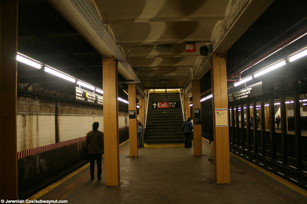
This station is the southernmost four-track express station on the Fourth Avenue Line with two island platforms. The N and R stop here at all times, while some rush-hour W trains stop here in the peak direction.[32][33][34] The R and W always run local, while the N runs express during the day and local at night. The next station to the north is 53rd Street for local trains and 36th Street for express trains. The next station to the south is Bay Ridge Avenue for R trains and Eighth Avenue for N and W trains.[35]
South of the station are diamond crossovers between each pair of local and express tracks. They are used by the N at night as well as limited W trains during rush hours. The R continues south along Fourth Avenue to Bay Ridge–95th Street while the N and W turn east and branch off to the BMT Sea Beach Line.[36]
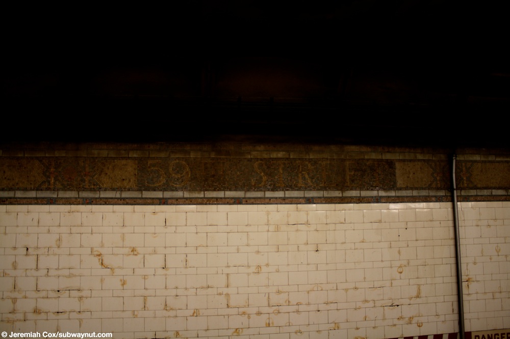
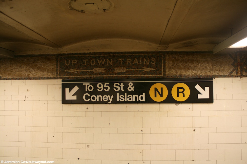
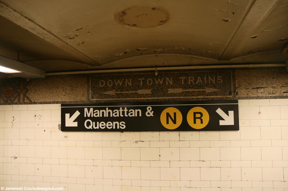
The station walls have mosaic trim lines on top of the white tiles, and spell 59th Street at intervals.[37] The northern sections of the station are where the platforms were extended in 1970, and they have no mosaic trims or tiles along the wall, instead including an extension of the tunnel benchwall.[38] Two sets of columns run along the entire length of both platforms and are painted yellow.[39] The mosaic trim lines are also present in the mezzanines. At the top of the pairs of staircases to each of the platforms, in the trim lines, there are directional mosaics.[40] Those to the Brooklyn-bound platform say "UP TOWN TRAINS",[41] while those to the Manhattan-bound platform say "DOWN TOWN TRAINS".[42]
Exits
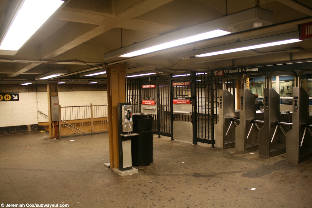
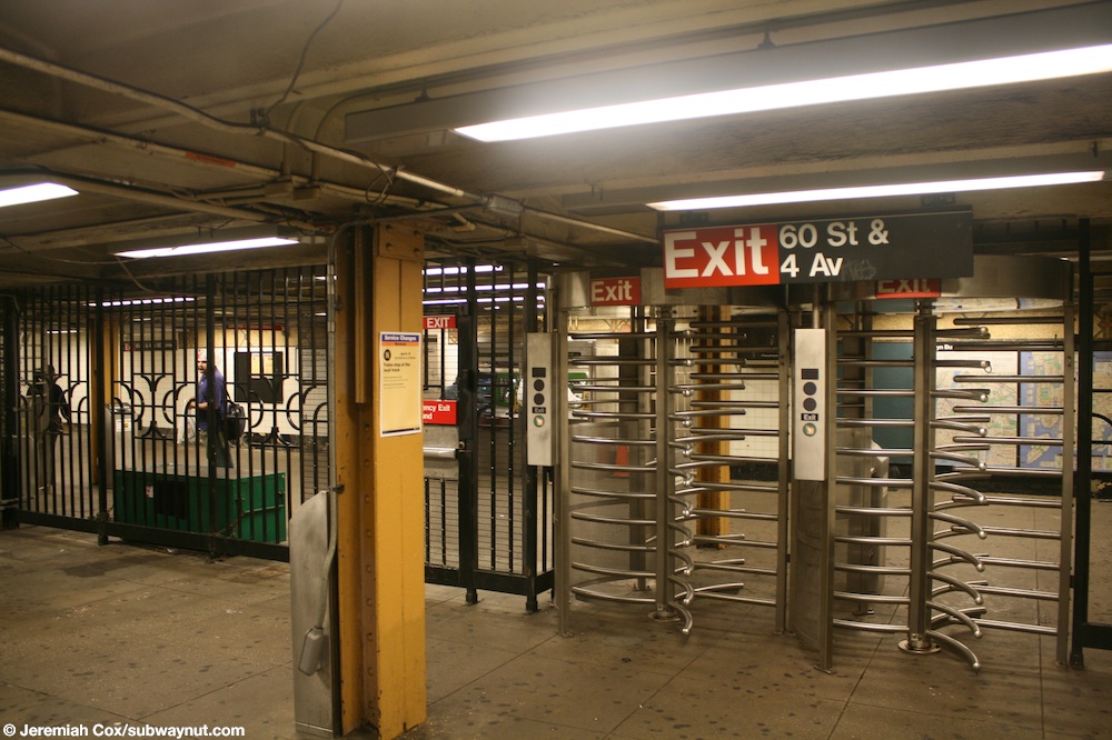
The street-level entrances are at the southern end of the station, with one entrance along either side of Fourth Avenue between 60th and 61st Streets. This part-time exit is unstaffed and has High Entry-Exit Turnstiles.[43] There are also four exits to Fourth Avenue and 59th Street, which includes two staircases to the northeast corner, along with one staircase and elevator to the northwest corner, at the north end of the station.[44] Each entrance has its own small mezzanine, and allows for crossovers between platforms.[40][45]
Provisions for proposed extensions

Immediately south of the station, there are tunnel stub headings running straight from the local tracks. They run for about 150 feet (46 m) and would have been for a line to Staten Island via the Staten Island Tunnel under the Narrows, which was aborted by Mayor Hylan before it was completed.[46][47] There is a "maintenance of way" shed that was built on the southbound trackway.[48] The northbound trackway is unobstructed, albeit much darker.[49] The northbound trackway ends on a brick wall, with evidence of a void space beyond. South of this station, the bridge over the LIRR Bay Ridge Branch has four trackways, with the outer tracks occupying the two western ones. The tracks of the BMT Fourth Avenue Line are under the western half of Fourth Avenue at this point so that two additional tracks could be laid in the future if traffic warranted it.[9][50]
The original proposal planned a connection from a point between 65th and 67th Streets, just south of the station, running to Arrietta Street near the Tompkinsville station in Tompkinsville, Staten Island.[51] A later plan called for a connection to St. George, Staten Island, near St. George Terminal.[52] Construction for the latter started in 1923, but the project was canceled in 1925.[52][53][54]
Points of interest
The Basilica of Our Lady of Perpetual Help, the largest church in Brooklyn, is located one block east on Fifth Avenue between 59th and 60th Streets.[55] The Brooklyn Army Terminal is located two blocks west,[44] along with the NYC Ferry pier there, though there is no free transfer between the subway and the ferry.[4]
Notes
References
- ^ "Borough of Brooklyn, New York City". Government of New York City. Archived from the original on September 14, 2020. Retrieved April 16, 2020.
- ^ "Glossary". Second Avenue Subway Supplemental Draft Environmental Impact Statement (SDEIS) (PDF). Vol. 1. Metropolitan Transportation Authority. March 4, 2003. pp. 1–2. Archived from the original (PDF) on February 26, 2021. Retrieved January 1, 2021.
- ^ "Brooklyn Bus Map" (PDF). Metropolitan Transportation Authority. October 2020. Retrieved December 1, 2020.
- ^ a b "Routes and Schedules: South Brooklyn". NYC Ferry.
- ^ a b c "Through Tube to Coney, 48 Minutes: First Train on Fourth Avenue Route Beats West End Line Eleven Minutes". The Brooklyn Daily Eagle. June 22, 1915. Retrieved June 29, 2015 – via newspapers.com
 .
.
- ^ "Annual Subway Ridership (2017–2022)". Metropolitan Transportation Authority. 2022. Retrieved November 8, 2023.
- ^ a b "B.M.T. Stations Ready For Eight-Car Trains". Brooklyn Standard Union. August 1, 1927. p. 1. Retrieved April 9, 2020 – via newspapers.com .
- ^ a b New York City Transit Authority Annual Report For The Year June 30, 1960. New York City Transit Authority. 1960. pp. 16–17.
- ^ a b c Rogoff, David (May 1961). "The Fourth Ave. Subway". New York Division Bulletin. Electric Railroaders' Association: 2–10. Retrieved May 8, 2017.
- ^ a b Fourth Avenue Subway, Brooklyn's New Transportation Line: A Part of the Dual System of Rapid Transit of the City of New York. New York City: Public Service Commission. June 19, 1915. p. 18. hdl:2027/uiug.30112067596715 – via HathiTrust.
- ^ "Fourth Avenue Subway Is Sent To A Committee". The Brooklyn Daily Eagle. March 20, 1908. pp. 1–2. Retrieved May 4, 2017 – via newspapers.com .
- ^ a b Fourth Avenue Subway, Brooklyn's New Transportation Line: A Part of the Dual System of Rapid Transit of the City of New York. Public Service Commission. June 19, 1915.
- ^ Cudahy, Brian J. (2009). How We Got to Coney Island: The Development of Mass Transportation in Brooklyn and Kings County. Fordham University Press. pp. 217–218. ISBN 978-0-8232-2211-7. Retrieved April 24, 2020.
- ^ Legislature, New York (State) (1923). Second Annual Report of the Transit Commission (For the Calendar Year 1922). New York State Transit Commission. p. 100.
- ^ Proceedings of the Transit Commission, State of New York Volume III From January 1 to December 31, 1923. New York State Transit Commission. 1923. p. 1277.
- ^ "12 B-M. T. Stations To Be Lengthened". The New York Times. February 17, 1925. ISSN 0362-4331. Retrieved May 4, 2017.
- ^ "Board Receives Platform Bids For B.M.T. Lines. Six Companies Submit Prices for Extending Subway Stations". The Brooklyn Citizen. February 26, 1926. p. 5. Retrieved April 7, 2020 – via newspapers.com .
- ^ "Brooklyn Wins Big Improvement Fund". Brooklyn Standard Union. March 18, 1926. p. 20. Retrieved April 7, 2020 – via newspapers.com .
- ^ "B.M.T. Lines Pass to City Ownership; $175,000,000 Deal Completed at City Hall Ceremony-- Mayor 'Motorman No. 1'". The New York Times. June 2, 1940. ISSN 0362-4331. Archived from the original on July 19, 2021. Retrieved May 14, 2022.
- ^ "City Takes Over B. M. T. System; Mayor Skippers Midnight Train". New York Herald Tribune. June 2, 1940. p. 1. ProQuest 1243059209.
- ^ Minutes and Proceedings. New York City Transit Authority. 1967. pp. 379–380.
- ^ Engineering News-record. McGraw-Hill. 1968. p. 75.
- ^ Rogoff, Dave (February 1969). "BMT Broadway Subway Platform Extensions" (PDF). New York Division Bulletin. 12 (1). Electric Railroaders' Association: 4. Archived from the original (PDF) on September 15, 2020. Retrieved May 22, 2020.
- ^ Goldman, Ari L. (April 28, 1983). "M.T.A. Making Major Addition to Capital Plan". The New York Times. ISSN 0362-4331. Archived from the original on April 25, 2022. Retrieved May 4, 2023.
- ^ "Transit and Bus Committee Meeting" (PDF). Metropolitan Transportation Authority. February 20, 2018. p. 326. Archived from the original (PDF) on February 19, 2018. Retrieved February 18, 2018.
- ^ Transit and Bus Committee Meeting January 2019 (PDF) (Report). January 22, 2019. Archived from the original (PDF) on March 26, 2020.
- ^ "New York City Transit and Bus Committee Meeting March 2020". mta.info. Metropolitan Transportation Authority. March 25, 2020. p. 172. Archived from the original on March 26, 2020. Retrieved February 2, 2020.
- ^ DeJesus, Jaime (July 21, 2020). "MTA expects to finish 59th Street elevators by October". The Brooklyn Home Reporter. Retrieved November 6, 2020.
- ^ DeJesus, Jaime (November 12, 2020). "Elevators open at 59th Street subway station". The Brooklyn Home Reporter. Retrieved May 5, 2021.
- ^ "MTA installs more new elevators at various subway stations". ABC7 New York. November 10, 2020. Retrieved May 5, 2021.
- ^ "Transit and Bus Committee Meeting". Metropolitan Transportation Authority. July 19, 2021. p. 144. Retrieved July 16, 2021.
- ^ "N Subway Timetable, Effective August 28, 2023". Metropolitan Transportation Authority. Retrieved August 26, 2023.
- ^ "R Subway Timetable, Effective August 28, 2023". Metropolitan Transportation Authority. Retrieved August 26, 2023.
- ^ "W Subway Timetable, Effective June 26, 2022". Metropolitan Transportation Authority. Retrieved August 26, 2023.
- ^ "Subway Map" (PDF). Metropolitan Transportation Authority. September 2021. Retrieved September 17, 2021.
- ^ Dougherty, Peter (2006) [2002]. Tracks of the New York City Subway 2006 (3rd ed.). Dougherty. OCLC 49777633 – via Google Books.
- ^ Cox, Jeremiah (June 9, 2009). "A faded 59 Street mosaic name tablet sign along the Manhattan-bound local track". subwaynut.com. Retrieved December 18, 2018.
- ^ Hodurski, Michael (February 21, 2007). "Platform view". www.nycsubway.org. Retrieved December 18, 2018.
- ^ Cox, Jeremiah (June 9, 2009). "A final view on the Manhattan & Queens Platform at 59 St for one of the staircases that has an old format sign for 59 St & 4 Av". subwaynut.com. Archived from the original on March 8, 2016. Retrieved December 18, 2018.
- ^ a b Cox, Jeremiah (June 9, 2009). "The turnstiles out to 59 St & 4 Av in its small mezzanine area". subwaynut.com. Retrieved December 18, 2018.
- ^ Cox, Jeremiah (June 9, 2009). "A mosaic sign for Up Town Trains, N R trains to 95 St & Coney Island on the mezzanine at 59 St & 4 Av". subwaynut.com. Retrieved December 18, 2018.
- ^ Cox, Jeremiah (June 9, 2009). "An old mosaic sign on the mezzanine for 59 St & 4 Av for Down Town Trains, the Manhattan & Queens trains". subwaynut.com. Archived from the original on March 8, 2016. Retrieved December 18, 2018.
- ^ Whitehorne, Wayne (June 4, 1999). "Showing Image 1131". www.nycsubway.org. Retrieved December 18, 2018.
- ^ a b "MTA Neighborhood Maps: Sunset Park" (PDF). Metropolitan Transportation Authority. 2018. Retrieved October 1, 2018.
- ^ Cox, Jeremiah (June 9, 2009). "Two High Exit/Entrance Turnstiles in the decently sized mezzanine area at the now unstaffed exit to 60 Street at 59 Street". subwaynut.com. Retrieved December 18, 2018.
- ^ Leigh, Irvin; Matus, Paul (December 23, 2001). "Staten Island Rapid Transit by Irvin Leigh & Paul Matus – Page 9". www.thethirdrail.net. Archived from the original on April 2, 2015. Retrieved March 26, 2020.
- ^ Taft, Lyman W. (October 13, 1954). "Finds Many Unused Subway Tunnels Under City Streets". The Brooklyn Daily Eagle. p. 24. Retrieved September 16, 2015 – via newspapers.com .
- ^ RFW of The Brooklyn Bound R Part 6: Prospect Avenue to Bay Ridge Avenue (video). October 17, 2009. Archived from the original on November 14, 2021. Retrieved April 18, 2020 – via YouTube.
- ^ RFW Of The Queens bound R Train Part 1: 95th Street to 45th Street (video). August 31, 2009. Archived from the original on November 14, 2021. Retrieved April 18, 2020 – via YouTube.
- ^ "Brooklyn Subway Extension Plan: Fourth Ave. Line to 86th St., Tunnel to Staten Island, and Eventually a Through Route to Coney Island" (PDF). The New York Times. February 16, 1912. Retrieved June 28, 2015.
- ^ Raskin, Joseph B. (2013). The Routes Not Taken: A Trip Through New York City's Unbuilt Subway System. New York, New York: Fordham University Press. doi:10.5422/fordham/9780823253692.001.0001. ISBN 978-0-82325-369-2.
- ^ a b Young, James C. (May 10, 1925). "Staten Island Waits for Narrows Tunnel; Mayor Hylan's Plan to Build a Tube That Can Be Adapted to Freight Traffic Raises Anew the Issue of New York Port Development". The New York Times. ISSN 0362-4331. Retrieved November 24, 2019.
- ^ N, Virginia (January 31, 2016). "'Old' St. George: Take this tour back into history". silive. Retrieved November 23, 2019.
- ^ Rastorfer, Darl (2000). "Chapter 7: The Verrazano-Narrows Bridge". Six Bridges: The Legacy of Othmar H. Ammann. Six Bridges: The Legacy of Othmar H. Ammann. Yale University Press. p. 135. ISBN 978-0-300-08047-6. Retrieved September 18, 2018.
- ^ "Historic Structures Report: Sunset Park Historic District" (PDF). National Register of Historic Places, National Park Service. August 3, 1988. p. 61.
External links
- nycsubway.org – BMT 4th Avenue Line: 59th Street
- Station Reporter — N Train
- Station Reporter — R Train
- The Subway Nut — 59th Street Pictures Archived January 5, 2018, at the Wayback Machine
- 59th Street entrance from Google Maps Street View
- Fourth Avenue entrance, midblock between 60th and 61st Streets, from Google Maps Street View
- Platforms from Google Maps Street View