
| 2021 British Columbia wildfires | |
|---|---|
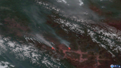 Satellite imagery showing wildfires in British Columbia producing pyrocumulonimbus clouds spawning lightning strikes. | |
| Date(s) | Evacuations: 19th April 2021 |
| Location | British Columbia, Canada |
| Statistics | |
| Land use | Forest and residential |
| Impacts | |
| Deaths | 2 |
| Non-fatal injuries | Several |
| Structures destroyed | Unknown, Estimated 90% of Lytton, British Columbia destroyed in Lytton Creek fire,[1] Village of Monte Lake destroyed and Paxton Valley destroyed |
| Damage | Unknown |
| Ignition | |
| Cause | Lightning and Human-Caused |
The 2021 British Columbia wildfires burned across the Canadian province of British Columbia. The severity of the 2021 wildfire season is believed[who?] to have been caused by a "perfect storm" of environmental factors possibly exacerbated by human-caused climate change.[2][3]
As of August 16, over 1,500 fires had been recorded according to the BC Wildfire Service.[4] The Sparks Lake Fire was the largest fire burning in the province, having burned an estimated 95,980 hectares (237,172 acres) of the Bonaparte Plateau northwest of the city of Kamloops.[5][6][7][8]
Development
A heat dome gripped the province of British Columbia, and much of Western North America, from June 25–30, 2021, increasing the risk of wildfires.[9]
On June 30, the town of Lytton was evacuated due to a fire that destroyed most buildings and grew to over 300 square miles (780 km2)[10][11] and sent people fleeing for their lives.
By July 1, 2021, almost 500 wildfires were burning across British Columbia. On July 20 the B.C. government declared a state of emergency.[12]
Wildfires
The following is a list of fires that burned more than 405 ha (1,000 acres), or produced significant structural damage or casualties. More up to date information is available using this interactive map; BC Wildfire Service Map
| Name | Regional district | Hectares (acres) | Start date | Containment status | Notes | Ref |
|---|---|---|---|---|---|---|
| George Road Fire | Thompson-Nicola | 5,017 ha (12,400 acres) | June 16 | Being held | Human-caused | [13] |
| Beatton River Fire | Peace River | 3,400 ha (8,400 acres) | June 28 | Under control | Lightning-caused | [14] |
| Buckinghorse Fire | Peace River | 6,398 ha (15,810 acres) | June 28 | Under control | Lightning-caused | [15] |
| Sparks Lake Fire | Thompson-Nicola | 89,627 ha (221,470 acres) | June 28 | Under control | Largest wildfire by area burned | [16] |
| McKay Creek Fire | Squamish-Lillooet | 44,964 ha (111,110 acres) | June 29 | Under control | Suspected human-caused | [17] |
| Minaker Fire | Peace River | 2,856 ha (7,060 acres) | June 29 | Under control | Lightning-caused | [18] |
| Klawli Lake Fire | Bulkley-Nechako | 6,231 ha (15,400 acres) | June 30 | Under control | Lightning-caused | [19] |
| Lytton Creek Fire | Thompson-Nicola | 83,740 ha (206,900 acres) | June 30 | Under control | Destroyed the village of Lytton; two confirmed casualties | [20] |
| Mckinley Lake Fire | Cariboo | 1,835 ha (4,530 acres) | June 30 | Being held | Lightning-caused | [21] |
| South of Canim Lake Fire | Cariboo | 3,049 ha (7,530 acres) | June 30 | Under control | Lightning-caused | [22] |
| SW of Deka Lake Fire | Cariboo | 650 ha (1,600 acres) | June 30 | Under control | Lightning-caused | [23] |
| Young Lake Fire | Thompson-Nicola | 7,453 ha (18,420 acres) | June 30 | Under control | Lightning-caused | [24] |
| Chilako Fire | Bulkley-Nechako | 1,451 ha (3,590 acres) | July 1 | Under control | Lightning-caused | [25] |
| Mount Porter Fire | Bulkley-Nechako | 13,659 ha (33,750 acres) | July 1 | Being held | Lightning-caused | [26] |
| Succour Lake Fire | Cariboo | 1,600 ha (4,000 acres) | July 1 | Being held | Lightning-caused | [27] |
| Tentfire Creek Fire | Peace River | 3,148 ha (7,780 acres) | July 1 | Being held | Lightning-caused | [28] |
| Big Stick Lake Fire | Cariboo | 7,195 ha (17,780 acres) | July 2 | Under control | [29] | |
| Black Pine Fire | Peace River | 16,314 ha (40,310 acres) | July 2 | Under control | Lightning-caused | [30] |
| Churn Creek Protected Area Fire | Thompson-Nicola | 12,101 ha (29,900 acres) | July 2 | Being held | Lightning-caused | [31] |
| Cultus Creek Fire | Central Kootenay | 2,665 ha (6,590 acres) | July 2 | Being held | Lightning-caused | [32] |
| Cutoff Creek Fire | Bulkley-Nechako | 33,418 ha (82,580 acres) | July 2 | Being held | Lightning-caused | [33] |
| Hotnarko Creek Fire | Central Coast | 1,500 ha (3,700 acres) | July 3 | Being held | Lightning-caused | [34] |
| Forres Mountain Fire | Peace River | 8,700 ha (21,000 acres) | July 4 | Under control | Lightning-caused | [35] |
| Purdy Lake Fire | Cariboo | 8,100 ha (20,000 acres) | July 5 | Under control | Lightning-caused | [36] |
| Bunting Road Fire | North Okanagan | 5,204 ha (12,860 acres) | July 7 | Being held | [37] | |
| Chief Louie Lake Fire | Bulkley-Nechako | 20,750 ha (51,300 acres) | July 7 | Being held | Lightning-caused | [38] |
| Momich Lake Fire | Thompson-Nicola | 17,049 ha (42,130 acres) | July 7 | Under control | [39] | |
| Flat Lake Fire | Thompson-Nicola | 74,194 ha (183,340 acres) | July 8 | Under control | Lightning-caused | [40] |
| Akokli Creek Fire | Central Kootenay | 3,636 ha (8,980 acres) | July 9 | Being held | Lightning-caused | [41] |
| Embleton Mountain Fire | Thompson-Nicola | 991 ha (2,450 acres) | July 9 | Under control | [42] | |
| Hunakwa Lake Fire | Columbia-Shuswap | 3,601 ha (8,900 acres) | July 9 | Being held | Lightning-caused | [43] |
| Mowhokam Creek Fire | Thompson-Nicola | 5,097 ha (12,590 acres) | July 9 | Being held | Lightning-caused | [44] |
| Trozzo Creek Fire | Central Kootenay | 5,992 ha (14,810 acres) | July 9 | Under control | Lightning-caused | [45] |
| Bill Nye Mountain Fire | East Kootenay | 2,990 ha (7,400 acres) | July 10 | Being held | Lightning-caused | [46] |
| Crazy Creek Gorge FSR Fire | Columbia-Shuswap | 4,389 ha (10,850 acres) | July 10 | Being held | Lightning-caused | [47] |
| Grizzly Lake Fire | Bulkley-Nechako | 4,891 ha (12,090 acres) | July 10 | Under control | Lightning-caused | [48] |
| Michaud Creek Fire | Central Kootenay | 14,032 ha (34,670 acres) | July 10 | Being held | Lightning-caused | [49] |
| Thomas Creek Fire | Okanagan-Similkameen | 10,597 ha (26,190 acres) | July 11 | Being held | [50] | |
| Three Valley Lake Fire | Columbia-Shuswap | 498 ha (1,230 acres) | July 11 | Under control | [51] | |
| Tremont Creek Fire | Thompson-Nicola | 62,524 ha (154,500 acres) | July 12 | Under control | [52] | |
| Chasm Fire | Thompson-Nicola | 454 ha (1,120 acres) | July 13 | Under control | Lightning-caused | [53] |
| July Mountain Fire | Thompson-Nicola | 19,080 ha (47,100 acres) | July 13 | Being held | Lightning-caused; merged with Brook Creek Fire | [54] |
| White Rock Lake Fire | Thompson-Nicola | 81,483 ha (201,350 acres) | July 13 | Being held | Lightning-caused. Destroyed the village of Monte Lake; part of the city of Kamloops placed under evacuation order, firefighter injured after falling several meters. | [55][56] |
| Brenda Creek Fire | Central Okanagan | 824 ha (2,040 acres) | July 14 | Under control | [57] | |
| Octopus Creek Fire | Central Kootenay | 22,049 ha (54,480 acres) | July 14 | Being held | Lightning-caused | [58] |
| Nk'Mip Creek Fire | Okanagan-Similkameen | 19,335 ha (47,780 acres) | July 19 | Being held | [59] | |
| Two Mile Road Fire | Columbia-Shuswap | 2,455 ha (6,070 acres) | July 20 | Being held | [60] | |
| Garrison Lake Fire | Okanagan-Similkameen | 14,564 ha (35,990 acres) | July 23 | Being held | [61] | |
| Pine River Fire | Peace River | 2,542 ha (6,280 acres) | August 13 | Being held | [62] | |
| Mt Law Fire | Okanagan-Similkameen | 976 ha (2,410 acres) | August 15 | Under control | Suspected human-caused. Parts of West Kelowna evacuated. | [63] |
References
- ^ Nassar, Hana Mae; Gul, Monika; James, Paul (1 July 2021). "'The situation is very, very dire': 90 per cent of Lytton burned, says BC MP". CKWX. Retrieved 2 July 2021.
- ^ "What you need to know about B.C. wildfires for Aug. 12". CBC News. 2020-08-12. Retrieved 2020-08-16.
- ^ "Canada's BC declares state of emergency as wildfires surge". www.aljazeera.com. Retrieved 2021-08-17.
- ^ "BC Wildfire Dashboard ArcGIS Dashboards". governmentofbc.maps.arcgis.com. Retrieved 2021-08-17.
- ^ "Wildfires of Note". bcfireinfo.for.gov.bc.ca. Retrieved 2021-08-17.
- ^ Peters, James (1 July 2021). "TNRD expands evacuation alerts near Sparks Lake wildfire". CFJC-TV. Archived from the original on 2021-07-01.
- ^ "Sparks Lake fire now estimated at 200 square kilometres in size". Kamloops This Week. 1 July 2021. Archived from the original on 2021-07-02.
- ^ "Sparks Lake wildfire remains largest in B.C." Kamloops This Week. July 14, 2021.
- ^ Eva Uguen-Csenge, Bethany Lindsay (29 June 2021). "For 3rd straight day, B.C. village smashes record for highest Canadian temperature at 49.6 C". CBC News. Archived from the original on 2021-06-30.
- ^ Lindsay, Bethany; Dickson, Courtney (30 June 2021). "Village of Lytton, B.C., evacuated as mayor says 'the whole town is on fire'". CBC News. Archived from the original on 2021-06-30.
- ^ Carrigg, David; Raptis, Mike; Bains, Camille; Brown, Scott (2 July 2021). "B.C. Wildfires: Search underway for Lytton residents missing after village engulfed by fire". Vancouver Sun. Archived from the original on 2021-07-01.
- ^ "B.C. declares state of emergency as wildfires grow, forcing more evacuations". CBC News. 20 July 2021. Retrieved 21 July 2021.
- ^ "Wildfires of Note George Road K70804". Government of British Columbia. Archived from the original on 2021-06-18.
- ^ "Wildfires of Note Beatton River G81007". Government of British Columbia. Archived from the original on 2021-07-14.
- ^ "Wildfires of Note G80997". Government of British Columbia. Archived from the original on 2021-07-09.
- ^ "Wildfires of Note Sparks Lake K21001". Government of British Columbia. Archived from the original on 2021-06-30.
- ^ "Wildfires of Note Mckay Creek (K71030)". Government of British Columbia. Archived from the original on 2021-07-02.
- ^ "Wildfires of Note G91020". Government of British Columbia. Archived from the original on 2021-07-14.
- ^ "Wildfires of Note Klawli Lake G61132". Government of British Columbia. Archived from the original on 2021-07-13.
- ^ "Wildfires of Note Lytton Creek". Government of British Columbia. Archived from the original on 2021-07-02.
- ^ "Wildfires of Note Mckinley Lake C31056". Government of British Columbia. Archived from the original on 2021-07-14.
- ^ "Wildfires of Note South of Canim Lake C41100". Government of British Columbia. Archived from the original on 2021-07-14.
- ^ "Wildfires of Note SW of Deka Lake C41102". Government of British Columbia. Archived from the original on 2021-07-02.
- ^ "Wildfires of Note Young Lake C41097". Government of British Columbia. Archived from the original on 2021-07-15.
- ^ "Wildfires of Note Chilako G11126". Government of British Columbia. Archived from the original on 2021-07-06.
- ^ "Wildfires of Note Mount Porter G61192". Government of British Columbia. Archived from the original on 2021-07-13.
- ^ "Wildfires of Note Succour Lake C41191". Government of British Columbia. Archived from the original on 2021-07-14.
- ^ "Wildfires of Note Tentfire Creek G71138". Government of British Columbia. Archived from the original on 2021-07-06.
- ^ "Wildfires of Note Big Stick Lake C51290". Government of British Columbia. Archived from the original on 2021-07-11.
- ^ "Wildfires of Note Black Pine G61316". Government of British Columbia. Archived from the original on 2021-07-13.
- ^ "Wildfires of Note Churn Creek Protected Area C21250". Government of British Columbia. Archived from the original on 2021-07-14.
- ^ "Wildfires of Note Cultus Creek Modified Response N71245". Government of British Columbia. Archived from the original on 2021-07-25.
- ^ "Wildfires of Note Cutoff Creek G41269". Government of British Columbia. Archived from the original on 2021-07-06.
- ^ "Wildfires of Note Hotnarko Creek C51355". Government of British Columbia. Archived from the original on 2021-07-14.
- ^ "Wildfires of Note Forres Mountain G61381". Government of British Columbia. Archived from the original on 2021-07-13.
- ^ "Wildfires of Note Purdy Lake C11491". Government of British Columbia. Archived from the original on 2021-07-14.
- ^ "Widlfires of Note Bunting Road K41561". Government of British Columbia. Archived from the original on 2021-07-20.
- ^ "Wildfires of Note Chief Louie Lake R11562". Government of British Columbia. Archived from the original on 2021-07-18.
- ^ "Wildfires of Note Momich Lake K21658". Government of British Columbia. Archived from the original on 2021-07-18.
- ^ "Wildfires of Note Flat Lake C41602". Government of British Columbia. Archived from the original on 2021-07-14.
- ^ "Wildfires of Note Akokli Creek N71686". Government of British Columbia. Archived from the original on 2021-07-17.
- ^ "Wildfires of Note Embleton Mountain K21644". Government of British Columbia. Archived from the original on 2021-07-12.
- ^ "Wildfires of Note Hunakwa Lake K41676". Government of British Columbia. Archived from the original on 2021-07-17.
- ^ "Wildfires of Note Mowhokam Creek V11669". Government of British Columbia. Archived from the original on 2021-08-08.
- ^ "Wildfires of Note Trozzo Creek N51705". Government of British Columbia. Archived from the original on 2021-07-18.
- ^ "Wildfires of Note Bill Nye Mountain-MR N11629". Government of British Columbia. Archived from the original on 2021-07-17.
- ^ "Wildfires of Note Crazy Creek Gorge FSR K41769". Government of British Columbia. Archived from the original on 2021-08-02.
- ^ "Wildfires of Note Grizzly Lake G41711". Government of British Columbia. Archived from the original on 2021-07-15.
- ^ "Wildfires of Note Michaud Creek N51765". Government of British Columbia. Archived from the original on 2021-07-17.
- ^ "Wildfires of Note Thomas Creek K51794". Government of British Columbia. Archived from the original on 2021-07-13.
- ^ "Wildfires of Note Three Valley Lake K41807". Government of British Columbia. Archived from the original on 2021-07-22.
- ^ "Wildfires of Note Tremont Creek K21849". Government of British Columbia. Archived from the original on 2021-07-14.
- ^ "Wildfires of Note Chasm C41866". Government of British Columbia. Archived from the original on 2021-07-18.
- ^ "Widlfires of Note July Mountain K61882". Government of British Columbia. Archived from the original on 2021-07-20.
- ^ "Wildfires of Note White Rock Lake K61884". Government of British Columbia. Archived from the original on 2021-07-18.
- ^ "Firefighter injured after fall on White Rock Lake fire site". CFGC Today.
- ^ "Wildfires of Note Brenda Creek K51924". Government of British Columbia. Archived from the original on 2021-07-18.
- ^ "Wildfires of Note Octopus Creek N51800". Government of British Columbia. Archived from the original on 2021-07-17.
- ^ "Wildfires of Note Nk'Mip Creek K52061". Government of British Columbia. Archived from the original on 2021-07-20.
- ^ "Wildfires of Note Two Mile Road K42078". Government of British Columbia. Archived from the original on 2021-07-23.
- ^ "Wildfires of Note Garrison Lake K62088". Government of British Columbia. Archived from the original on 2021-07-25.
- ^ "Wildfires of Note Pine River G72591". Government of British Columbia. Archived from the original on 2021-08-18.
- ^ "Wildfires of Note Mt Law KK52627". Government of British Columbia. Archived from the original on 2021-08-16.