
| 1994 Pacific typhoon season | |
|---|---|
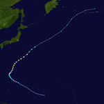
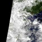
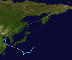
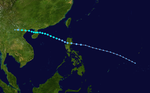
 Season summary map | |
| Seasonal boundaries | |
| First system formed | January 4, 1994 |
| Last system dissipated | December 27, 1994 |
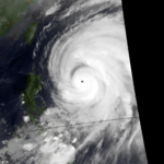
| Strongest storm | |
| Name | Melissa & Seth |
| • Maximum winds | 205 km/h (125 mph) (10-minute sustained) |
| • Lowest pressure | 910 hPa (mbar) |
| Seasonal statistics | |
| Total depressions | 52 |
| Total storms | 36 |
| Typhoons | 20 |
| Super typhoons | 6 (unofficial) |
| Total fatalities | 4,724 total |
| Total damage | $8.14 billion (1994 USD) |
| Related articles | |
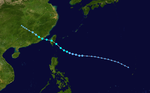
The 1994 Pacific typhoon season was an extremely active season in the annual cycle of tropical cyclone formation in the Western North Pacific, being the second most active season in the basin, only behind 1964. With a total of 36 tropical storms, where 20 of them reached typhoon strength and 6 further strengthening into super typhoons, during the course of the season, much like the Pacific hurricane season. The season had no official bounds and it ran year-round in 1994, but most tropical cyclones tend to form in the northwestern Pacific Ocean between May and November. Tropical storms that formed west of the date line were assigned a name by the Joint Typhoon Warning Center. The World Meteorological Organization-designated Regional Specialized Meteorological Centre for tropical cyclones for the region is the Japan Meteorological Agency. Tropical depressions that entered or formed in the Philippine area of responsibility were assigned a name by the Philippine Atmospheric, Geophysical and Astronomical Services Administration or PAGASA. This can result in some storms having two names.
The season started on January 4 with the formation of Tropical Depression 01W to the west of Yap, with the first tropical storm developing a few months later on April 1, and ended near the end of the year when Tropical Storm Bobbie dissipated in the open Pacific on December 25. During the season, 25 systems either threatened land or made landfall, killing over 2,400 people. The strongest storm of the season was Super Typhoon Doug, which affected Taiwan, South Korea and mainland China, while the deadliest storm was Super Typhoon Fred, which killed over 1,000 people in China. Earlier in the season, the combined effects of two tropical storms —Russ and Sharon —caused flooding in China that killed over 1,400. The season also saw two storms, Li and John, cross into the Western North Pacific from the east, while one storm, Tropical Storm Yuri, formed from a precursor low that had similarly crossed the International Date Line. This season, PAGASA named 25 systems and had to use an auxiliary list to name some of them after running out of names from their standard list. Of the 25, three systems were not tracked by the Joint Typhoon Warning Center.
YouTube Encyclopedic
-
1/5Views:2 816129 5486 6087001 149 107
-
What is the Longest Lived Storm in History?
-
The Track of Typhoon Tip (1979)
-
2010 What-might-have-been Pacific Hurricane Season
-
Typhoon Ulysses: Himawari Satellite Animation 2020 Nov 7 to Nov 13 3840x3840 20FPS Enhanced
-
Formation Of A Tropical Cyclone
Transcription
Season summary

| Most storms in a singular Pacific typhoon season (1955-present) | |||
|---|---|---|---|
| Year | Tropical storms | Typhoons | |
| Typhoons | Super typhoons | ||
| 1964 | 39 | 26 (record high) | 7 |
| 1994 | 36 | 20 | 6 |
| 1971 | 35 | 24 | 6 |
| 1965 | 35 | 21 | 11 (record high; tied with 1997) |
| 1961 | 35 | 20 | 8 |
| 1967 | 35 | 20 | 5 |
| 1989 | 32 | 20 | 5 |
| 1974 | 32 | 16 | 0 (record low) |
| 1992 | 31 | 16 | 5 |
| 1955 | 31 | 20 | 4 |
| 2013 | 31 | 13 | 5 |
| Note: Data begins at the year 1955 due to earlier data being increasingly unreliable. Totals for tropical storms and typhoons are from the Japan Meteorological Agency, and totals for the unofficial super typhoon category are from the Joint Typhoon Warning Center. | |||
There were 41 tropical cyclones during 1994 in the Western North Pacific; 39 formed within the area while two, Tropical Storm Li and Typhoon John, formed in the Eastern North Pacific (east of longitude 140°W) and crossed the date line to enter this basin. Of the 39, 34 became tropical storms and were named, of which 17 became typhoons. The season started on January 4 with the formation of Tropical Depression One-W to the west of Yap, with the first tropical storm developing a few months later on April 1. The season ended late in the year after Tropical Storm Bobbie dissipated in the open Pacific on December 25.
During the season, 25 systems either threatened land or made landfall, with eight striking the Philippines, eight moving into China, six moving into Vietnam, and three striking Taiwan and China. A total of over 2,400 people perished during the season. The strongest storm of the season was Super Typhoon Doug, which affected Taiwan, South Korea and mainland China, while the deadliest storm was Super Typhoon Fred, which killed over 1,000 people in China. Earlier in the season, the combined effects of two tropical storms — Russ and Sharon — caused flooding in China that killed over 1,400. The season also saw two storms, Li and John, cross into the Western North Pacific from the east, while one storm, Tropical Storm Yuri, formed from a precursor low that had similarly crossed the International Date Line. Hong Kong received 28 percent of its annual rainfall from tropical cyclones this season, which was slightly above normal.[1]
Systems
Tropical Depression 01W (Akang)


The first tropical depression of the year was first observed as a poorly organized area of clouds, within a trough of low pressure near the Caroline Islands during January 1.[2] The system subsequently moved towards the north-northwest, while atmospheric convection surrounding the system organized further. As a result of this organization and a weather station on Chuuk island reporting wind speeds of 55 km/h (35 mph), the JTWC issued a Tropical Cyclone Formation Alert on the system during January 2.[2] However the system did not become a significant tropical cyclone during January 3, as it was not able to sustain its convective organization.[2] The system was subsequently classified as a tropical depression on January 4 while the system was about 600 km (370 mi), west of Yap.[1][2]
Tropical Depression 01W made landfall on Samar Island in the Philippines on the evening of January 5, following which the depression started to weaken. The final warning was issued early on January 6 after the system lost all its deep convection. A total of 35 to 45 deaths were reported, with over 69 million Philippine pesos (1994 pesos) or $2.4 million (1994 USD) in damage reported.[3][4] It caused a major flood event in the Philippines.[5] A total of at least 16,000 people had to take refuge in government-run shelters during and after the storm.[1]
Severe Tropical Storm Owen (Bising)


Typhoon Owen formed from a tropical disturbance which was originally identified within a near-equatorial trough over Micronesia. The disturbance was first mentioned by the Joint Typhoon Warning Center on March 29. By March 31, a distinct area within the trough showing signs of cyclonic spin appeared, and the JTWC initiated advisories on Tropical Depression 02W soon afterwards.[6] Meanwhile, the Japan Meteorological Agency classified the system as a tropical storm, Tropical Storm 9401.[7] It was located about 420 kilometres (260 mi) west-northwest of Yap.[1]
Owen continued to strengthen, with the JMA classifying it a severe tropical storm on April 3.[7] According to the JTWC, Owen reached typhoon intensity at the same time the JMA classified it a severe tropical storm. The storm tracked southwest to west-southwestward, and reached its peak intensity of 75 knots (139 km/h) from the JTWC (60 knots (110 km/h) from the JMA) on April 4, shortly before landfall between Leyte and Mindanao.[6] A reading taken late on April 3 at Guiuan on Samar reported sustained winds of 45 knots (83 km/h).[4] It weakened to a tropical storm overland, before it restrengthened slightly after emerging into the South China Sea. A drilling rig reported 50 knots (93 km/h) sustained winds. Soon afterwards, the cyclone dissipated over water northwest of Luzon on April 9.[6]
Owen's west-southwestward track shortly before landfall was rare. Owen was one of just two April typhoons in the previous 36 years — the other being Typhoon Wanda of the 1971 season – to make landfall while moving west-southwestward.[6] Owen's later recurvature in the South China Sea was also unusual; it recurved at a latitude of only about 13°N, about 3° south of the average latitude for recurvature in the South China Sea in April.[6]
Owen's impact on the Philippines was widespread, with nine provinces being declared under a "state of calamity" by President of the Philippines Fidel Ramos.[8] At least 10 people were killed with 5 others missing, and a further 14 fishermen feared drowned. A total of 33 were reported wounded. Over 9000 families were affected by Owen.[8] No damage was reported to the drilling rig in the South China Sea.[6]
In Okinawa, heavy rains were reported on Yonaguni, with a total reported precipitation amount of 313 millimetres (12.3 in).[9] The peak winds measured at Yonaguni in association with Typhoon Owen were 32.4 kilometres per hour (17.5 kn).[10]
Typhoon Page (Klaring)

On May 8, a large increase in deep convection associated with near-equatorial troughs was noted in the eastern Caroline Islands. By the next morning, visible satellite imagery showed an increase in organization of the deep convection associated with the system, and synoptic reports from buoys confirmed that a low-level circulation centre was present near 5°N 153°E / 5°N 153°E.[11] Slow development ensued, and the system was upgraded to a tropical depression on May 12.[11] At the same time, the Japan Meteorological Agency began tracking the system,[7] about 510 kilometres (320 mi) west-southwest of Guam.[1]
Page moved on a northwestward track for the next couple days while slowly strengthening.[11] Page was upgraded to a tropical storm by the JTWC late on May 12,[12] when it was located 500 kilometres (310 mi) north of Yap,[4] while the JMA first considered the system a tropical storm on May 13.[7] Late on May 13, Page suddenly slowed in forward speed and began turning to the northeast. On May 14, Page became a typhoon.[11][12] However, the JMA did not follow suit until 30 hours later.[7] Page reached its maximum intensity of 90 knots (170 km/h) and minimum pressure of 965 hectopascals (28.5 inHg) thirty hours after passing the point of recurvature.[11] Final warnings were issued by both the JTWC[11] and the JMA[7] early on May 18, as it began extratropical transition around 960 kilometres (600 mi) east-southeast of Tokyo.[11]
Page had the largest average track forecast errors of all the typhoons in 1994, mainly due to failures in expecting its recurvature.[11] Furthermore, Page's late attainment of maximum intensity, at 30 hours after point of recurvature, is not common. Between 1978 and 1993, only seven of 77 typhoons attained peak intensity more than 24 hours after recurving.[11]
Large waves and high tides generated by Page affected the western Mariana Islands. A few tourists had to be rescued from high surf and strong currents on Guam.[11] Minimal rainfall was recorded in Japan, the highest recorded total was 29 millimetres (1.1 in) in Kumagaya, Saitama.[13] At Mount Tsukuba, a maximum sustained wind speed of 58 kilometres per hour (31 kn) was recorded.[14]
Tropical Depression 04W (Deling)


On May 14, an area of deep convection associated with a weak cyclonic circulation near Kosrae was mentioned in the JTWC's 0600 UTC Significant Tropical Weather Advisory. For the next five days, this weak circulation tracked west-northwestward in the direction of Guam, before turning to the west-southwest, but convection failed to consolidate near the centre during this time.[15] After passing close to Palau on May 21, it turned northwest and entered the Philippine Sea, and was named Deling by PAGASA early on May 23 local time. Shortly after, SSM/I imagery indicated the presence of a well-defined low-level circulation centre, and visible and infrared satellite images indicated an increase in organisation of the system and a consolidation of deep convection near the centre. Based on this, a Tropical Cyclone Formation Alert was issued by the JTWC at 0600 UTC.[15]
The first warning was issued a day later when the amount of deep convection near the centre increased as the depression neared the Philippines. While over the Philippine islands, a large mesoscale convective system (MCS) developed near the centre of the tropical depression, something that would occur again later while the system was west of Luzon.[15] Soon after the second MCS weakened, the system made landfall in central Vietnam on May 26, and quickly dissipated when inland.[4] The Hong Kong Observatory tracked this system as a weak tropical depression from May 25 UTC when it was about 520 km (320 mi) southeast of Xisha for about 24 hours before it dissipated.[1]
According to press reports, over 2,000 people were forced to evacuate from Davao City, despite no reports of significantly high winds or low pressures, as the system caused heavy rainfall that produced heavy flooding that killed five people and left at least one person missing.[1][4]
Severe Tropical Storm Russ (Emang)


Tropical Storm Russ was one of just three storms to cause the Hong Kong Observatory to raise Tropical Cyclone Signal #3 in the 1994 season.[1] Russ was first spotted on June 2, about 140 kilometres (87 mi) east of Hainan Island as a tropical disturbance.[16] Deep convection over the circulation center soon improved, and the Hong Kong Observatory had declared it a tropical depression on June 3 when it was located about 290 kilometres (180 mi) south of Hong Kong.[1]
The system initially moved east to northeast while slowly strengthening. Russ became a tropical storm on the evening of June 4,[17] passing just south of Dongsha that night.[1] PAGASA then named the system Emang, shortly before it made a clockwise loop and started to move back towards the west-southwest, intensifying.[16] Russ made landfall on June 8 on the northeastern Luichow Peninsula, and weakened inland. The extratropical remnants continued east-northeast toward Japan before dissipating.[16]
The maximum wind gust in Hong Kong was reported at Tai Mo Shan, where a gust to 56 knots (104 km/h) was recorded on June 7. Maximum daily rainfall in the territory was recorded at Yuen Long on June 8, when 41.0 millimetres (1.61 in) was reported.[1] Russ killed at least 74 people in Hainan, Guangdong and Guangxi Provinces and injured another 726 people. 16 others were reported missing. 702,430 hectares (7,024.3 square kilometres; 2,712.1 square miles) of farmland in the three provinces were destroyed by floods from Russ. Around 725,000 houses were destroyed. Total damage was estimated at 6.3 billion RMB (1994 RMB),[1] or $727.5 million (1994 USD).[18]
Tropical Storm Sharon (Gading)


In mid-June, not long after Tropical Storm Russ had made landfall, an area of convection south of Chuuk within the near-equatorial trough began to consolidate. The system moved west-northwest as it began to organize on June 20. Acquiring tropical depression strength on June 21, intensification halted due to vertical wind shear. Subsequent weakened led to its dissipation as a tropical depression by June 22.[19]
PAGASA named the system Gading as it neared the Philippines, and twelve hours after the final warning was issued, convection once again built up, and a new warning was issued.[19] The Japan Meteorological Agency issued their first warning on Tropical Storm 9404 a day later.[7] As it crossed Luzon, Sharon caused flooding and released mudflows from Mount Pinatubo, killing two people. Traffic on two main highways near Manila was disrupted by the mud.[1]
After crossing Luzon, Sharon reached its peak, with vertical shear inhibiting further intensification.[19] It made landfall on June 25 around 140 metres (0.087 mi) east-northeast of Zhanjiang,[1] or 110 kilometres (68 mi) east of where Tropical Storm Russ had made landfall just weeks before.[19] Winds gusted to 52 knots (96 km/h) at Tai Mo Shan in Hong Kong. Sharon claimed 11 lives in the seas off Hong Kong,[1] and the combined flooding effects of Russ and Sharon reportedly left more than 1,400 people dead, and caused over $6 billion (1994 USD) in damage.[19]
Tropical Depression 07W


Tropical Depression 07W developed in the monsoon trough on June 29, well east of the Philippines.[20] Warnings were initiated at 0000 UTC June 3[20] when the system was approximately 250 km (160 mi) southeast of Dongsha.[4] It reached its maximum intensity shortly before landfall[20] on July 4.[4] Flooding associated with Tropical Depression 07W in western Guangdong Province killed four people and left two others missing, and destroyed over 6,700 houses while leaving another 50,000 damaged. 120,000 hectares (1,200 square kilometres; 460 square miles) of farmland were ruined, and irrigation facilities were damaged.[1] Total losses from the storm in Guangdong were estimated to be $114 million (1994 USD).[20] In Guangxi Province, the storm killed six others, and left over 30,000 people homeless.[1]
Typhoon Tim (Iliang)
A tropical disturbance formed in the Caroline Islands on July 5 south of a tropical upper tropospheric trough. The system organized into a tropical depression on the morning on July 6.[21] Moving northwest, the depression strengthened into a tropical storm as it approached 130°E on the morning of July 8.[7] Rapid intensification ensued, with Tim reaching typhoon intensity late on July 8, peaking at 125 knots (232 km/h) on July 10.[21]
From July 9 to July 11, Tim and Tropical Storm Vanessa engaged in a Fujiwara interaction,[21] and Tim absorbed the smaller Vanessa into its southeastern quadrant.[22] Late on July 10, Tim struck Taiwan, bringing gusts of 98 knots (181 km/h) to Chenggong[21] as it made landfall about 200 kilometres (120 mi) south of Taipei.[1] Continuing northwest, Tim moved into mainland China as a weaker typhoon, crossing the coast about 150 kilometres (93 mi) south-southwest of Fuzhou. It dissipated well inland on July 11.[21]
Damage was widespread in Taiwan, where Tim killed at least 19 people and left another 11 missing, and where 67 people reported injuries. A freighter with 97 mainland Chinese on board ran aground near Suao.[1] About 50,000 hectares (500 square kilometres; 190 square miles) of farmland was flooded, and more than 300 buildings collapsed during the storm. The bad weather also disrupted international flights, and knocked out electricity to over 2 million households. NT$2 billion (1994 TWD), or US$75 million (1994 dollars),[18] was the reported cost of damage.[1]
In Fujian Province, Typhoon Tim killed three people and flooded 140,000 hectares (1,400 square kilometres; 540 square miles) of farmland, with damages estimated at 1.5 billion renminbi (1994 RMB),[1] or $173.5 million (1994 USD).[18] Tim was also responsible for 14 deaths and 6 injuries in the Philippines (Pangasinan, Ilocos Sur and Ilocos Norte provinces) as it passed near the area.[23]
Tropical Storm Vanessa (Loleng)


As Tim developed in the Philippine Sea, a tropical disturbance in the South China Sea began to show development. Becoming a tropical depression late on July 8, it strengthened into a tropical storm early on July 9, with both the Joint Typhoon Warning Center and the Japan Meteorological Agency classifying it a tropical storm.[7][24]
Vanessa made an anti-clockwise loop and then started to move northeastward under the steering influence of a monsoon flow and Typhoon Tim's circulation, reaching a peak intensity of 45 knots (83 km/h) west of Luzon before it was absorbed by the larger typhoon. The final warning was issued on July 11 after it was determined that Vanessa's circulation had been absorbed.[22] Vanessa was responsible for three deaths in the Philippines, where it was known as Loleng.[23]
Typhoon Walt (Miding)


Walt was part of a three tropical cyclone outbreak along a reverse-oriented monsoon trough (aligned northeast–southwest rather than the usual northwest–southeast orientation.) By July 11, a thunderstorm cluster developed near Palau. The disturbance moved slowly northwest, becoming a tropical depression late on July 14. As it neared the 15th parallel, Walt turned to the northeast and intensified. By the afternoon of July 19 the cyclone had become a super typhoon, the first of the season, an intensity it maintained for a day. While slowly weakening, Walt turned to the west. By the morning of July 23 the cyclone had dropped down to tropical storm strength as it turned to the north for a couple days. The storm turned back to the west, making landfall on the southwest end of Shikoku as a moderate tropical storm, bringing wind gusts to tropical storm force. The cyclone dissipated south of Korea by early on July 27. Rainfall across South Korea helped improve severe drought conditions.[25]
Tropical Storm Yunya (Norming)


The disturbance that was to become Tropical Storm Yunya was first mentioned on July 16 by the Joint Typhoon Warning Center when it was located in the South China Sea as cloudiness in a reverse-oriented monsoon trough.[26] A weak low-level circulation was identified through animated satellite imagery and synoptic data early that morning. Moving east-northeast, the system strengthened into Tropical Depression 11W by July 18.[26] At 0600 UTC that day, the Japan Meteorological Agency declared the formation of Tropical Storm Yunya.[7] Yunya continued to undergo gradual strengthening, reaching its peak strength near landfall in northwest Luzon on the morning of July 19.[26]
As it tracked over land, it became disorganized and weakened to a minimal tropical storm. In the Philippine Sea, Yunya briefly restrengthened and reached a secondary peak of 40 knots (74 km/h).[26] The JMA discontinued warnings after it deemed Yunya to have dropped below tropical storm intensity at 1800 UTC that day,[7] while the JTWC continued monitoring the tropical depression until convection decreased and the storm dissipated on July 21.[26] During its life, Yunya had an unusual eastward motion, which was due to the reverse-oriented monsoon trough. Yunya was also a small system, and appeared to have been undergoing a period of rapid organisation of convection shortly before it made landfall.[26]
Heavy rain from Yunya caused landslides of volcanic debris from Mount Pinatubo. Coincidentally, a previous Typhoon Yunya in 1991 hit the Philippines the day of Mount Pinatubo's major eruption. Gusts were in excess of 60 knots (110 km/h) across Luzon.[26] Yunya killed at least 11 people and injured at least 7 others, and affected over 420,000 people. A total of $37.6 million (1994 USD) in damage was reported in the Philippines from Yunya.[23]
Severe Tropical Storm Zeke

Forming at the opposite end of the monsoon trough from Walt on July 14, the initial tropical disturbance moved north to northeast. Slowly developing, the system became a tropical depression during the early afternoon of July 18. Westerly upper-level shear from Walt was slowing development, and Zeke finally achieved tropical storm status early on July 20. The cyclone continued to waver around a northeast track. After turning more northward early on the afternoon of July 22, Zeke became a typhoon for half of a day. Wavering around a more northerly track, Zeke weakened and evolved into an extratropical cyclone on by early on July 25.[27]
Tropical Storm Amy

An area of persistent convection associated with a low-level circulation centre moved off Hainan Island into water on July 29.[28] The Japan Meteorological Agency then reported that Tropical Storm 9410 had formed early that day, in the Gulf of Tonkin west of Hainan.[7] This was later designated by the Joint Typhoon Warning Center as Tropical Depression 15W, and it was quickly upgraded to a tropical storm.[28] It moved westward and started to weaken over water, making landfall south of Hanoi before dissipating inland.[28]
Tropical Storm Amy killed 15 and left over 32,000 people displaced in Thailand and Cambodia, and caused damage worth $8 million (1994 USD).[5]
Tropical Depression 13W


Tropical Depression 13W was considered to be the shortest-lived tropical cyclone of the season, with the JTWC only four warnings issued on it.[29] It formed on July 25 in association with a surge in the southwest monsoon,[29] about 250 km (160 mi) east of Guam.[4] It dissipated the next day, east of the northernmost Mariana Islands,[29] about 250 km (160 mi) north of Guam.[4] No deaths or damage were reported from the depression. On July 28, a subtropical cyclone was noted southeast of Tokyo, and it is possible that this was a continuation of Tropical Depression 13W.[30]
Tropical Storm Brendan (Oyang)

On July 26 a tropical disturbance developed in the Philippine Sea. The system moved northwest at a slow pace for a couple days. A southwest surge in the monsoon turned the disturbance northward, and the system became a tropical depression on the morning of July 29. Accelerating to the north, Brendan became a tropical storm just before reaching Okinawa. The cyclone reached peak intensity to the south of Cheju Island, Korea as a moderate tropical storm. After recurving in the Yellow Sea, the storm recurved across Korea during extratropical transition with subtropical cyclone characteristics. The cyclone evolved into an extratropical cyclone while crossing the Sea of Japan, and reintensified. Up to 200 millimetres (7.9 in) of rain in the Korean peninsula helped relieve drought conditions. Two died in Korea during the passage of Brendan.[30]
Tropical Storm Caitlin (Pasing)
A tropical disturbance formed within the monsoon trough northwest of Guam on July 29. Slow development ensued, and four days later, it had become a tropical depression. By late on August 2 the cyclone had achieved tropical storm status. The system turned northwest and accelerated towards Taiwan/Taipei. During the morning of August 3, Caitlin became a storm tropical storm as it made landfall in Hualien county. Green Island experienced gusts of typhoon force for 21 hours as the cyclone's center moved to its north. Taking six hours to cross the mountainous island, Caitlin entered the Taiwan Straits on August 4. Ten perished across Taiwan and damage there totaled NT$620 million (1994 dollars),[1] or $23.4 million (1994 USD).[18] By late morning, its center passed inland into mainland China. Rainfall rates as high as 84 millimetres (3.3 in) per hour were witnessed in the Ningxia Hui autonomous region. Mountain floods left eight dead.[31]
Typhoon Doug (Ritang)


The eastern end of a monsoon trough developed a tropical depression on July 30. It headed westward, slowly strengthening to a tropical storm on the 2nd and a typhoon on the 3rd. Doug turned more to the northwest, and rapidly intensified from the 4th to the 5th to a 140 kn (260 km/h) super typhoon. It weakened slightly to a 125 kn (232 km/h) typhoon before brushing the eastern coast of Taiwan on the 7th. Its circulation became ragged, and it weakened to a tropical storm on the 10th. A ridge to the north pushed Doug west-southwestward where it dissipated over China on the 13th. A total of 26 people died,[1] and damage was estimated on Taiwan at $110 million (1994 USD).[32]
Typhoon Ellie

A tropical disturbance formed 900 kilometres (560 mi) southeast of Japan on August 2. The system drifted southward and slowly developed, becoming Tropical Depression 18W, and then a tropical storm, on August 8. The system turned to the west-southwest, forming a large eye as it became a typhoon on August 9 before stalling. On August 10, the system moved west-northwest at a moderate pace, passing 130 kilometres (81 mi) offshore southern Kyūshū on August 13. Ellie turned northward on August 14, clipping eastern China before making a final landfall within northeast China as a tropical storm on August 16.[32]
Tropical Storm Li
| Tropical storm (JMA) | |
| Tropical storm (SSHWS) | |
 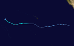 | |
| Duration | August 12 (Entered basin) – August 17 |
|---|---|
| Peak intensity | 85 km/h (50 mph) (10-min); 992 hPa (mbar) |
Late on August 12, Hurricane Li moved into the basin from the Central Pacific, with the JTWC and CPHC reporting that the system had weakened into a tropical storm as it crossed the International Date Line.[33][34] Over the next few days as Li moved northwestwards towards Wake Island, it weakened steadily under the influence of strong upper-level westerly winds.[34] During August 14, the JMA reported that the system had weakened into a tropical depression, before the JTWC followed suit during the next day as it affected Wake Island.[7][33][35] The system was last noted as it dissipated over open water during August 18.[34]
Typhoon Fred (Susang)

On August 15, Tropical Depression 19W became a tropical storm over the open West Pacific. Fred tracked westward, slowly intensifying to a typhoon on August 16 and a peak of 130 kn (240 km/h) winds on August 19. Unlike most super typhoons, Fred did not rapidly intensify; its strengthening rate was steady. As it passed by Taiwan, heavy rainfall caused landslides across the mountainous island. Three perished and a total of NT$22 million (1994 dollars), or $835,500 (1994 USD),[18] of damage occurred within Taiwan.[1]
The storm weakened to an 85 kn (157 km/h) typhoon before hitting eastern China on August 21. Significant infrastructure damage occurred near the location of landfall. Unfortunately, the landfall coincided with an unusually high astronomical tide, resulting in extreme storm surge combined with heavy flooding, amounting to over 1,000 fatalities and significant damage totaling 7.5 billion RMB,[1][32] or $874.4 million (1994 USD).[18]
Typhoon Gladys (Uding)


On August 19, a small area of thunderstorm activity formed in the open tropical western Pacific Ocean on the eastern end of the monsoon trough. By August 22, the system organized into a small tropical cyclone, which was heading off towards the north. On August 23, the system turned westward due to increased ridging to its north. It soon became a tropical storm on August 24, and developed into a typhoon on August 25. Westerly vertical wind shear led to weakening, and Gladys became a weak tropical storm on August 28. The wind shear relented, and Gladys redeveloped into a typhoon as it moved towards Taiwan, increasing in size as well as intensity. The system weakened as it tracked across northern Taiwan, prior to making landfall over mainland China, dissipating on September 2. Winds at Suao gusted to 133 knots (246 km/h) as it moved by northern Taiwan. Six people perished.[32] A total of NT$400 million (1994 dollars), or $15.4 million (1994 USD),[18] in agricultural damage was incurred across Taiwan.[1]
Tropical Storm Harry

Thunderstorm activity developed within the monsoon trough 465 kilometres (289 mi) southwest of Guam. The system tracked west-northwest, a course it would continue through its life cycle. After crossing the northern portion of Luzon, the system became a tropical depression late on August 25 and a tropical storm on August 26. On the morning of August 27, the cyclone passed south of Hong Kong, bringing wind gusts to 56 knots (104 km/h) at Waglan Island and 76 knots (141 km/h) at Tai Mo Shen in Hong Kong.[1] Harry became a strong tropical storm before moving close to the Chinese coast. Total damage across China from Harry's heavy rainfall totaled 484 million RMB (1994 RMB),[1] or $56.5 million (1994 USD).[18] Weakening thereafter, the storm moved across the Gulf of Tonkin into northern Vietnam, dissipating on August 29.[32]
Tropical Depression Tering

This system was recognized as a tropical depression by PAGASA. It formed several hundred miles east of the Philippines on August 29, tracking north of due west, and dissipating on August 30 before reaching the island archipelago.[36]
Typhoon Ivy


On August 25, a low-pressure area developed in the subtropical western Pacific. The low traveled west-southwest, slowly gaining thunderstorms. On August 28, the system became a tropical depression, then tropical storm, as it turned to the north. Ivy continued to develop, becoming a typhoon on August 31. During early September, the system turned north-northeast and slowly weakened. On September 3, Ivy transitioned into an extratropical cyclone as it linked up with a cold front.[32]
Typhoon John
| Very strong typhoon (JMA) | |
| Category 3 typhoon (SSHWS) | |
  | |
| Duration | August 28 (Entered basin) – September 8 (Exited basin) |
|---|---|
| Peak intensity | 155 km/h (100 mph) (10-min); 945 hPa (mbar) |
On August 28, Hurricane John, which had formed in the Eastern North Pacific, crossed the International Date Line at 0900 UTC and became a typhoon. Shortly after crossing into the Western North Pacific, John reached its secondary peak of 105 knots (195 km/h). While west-southwest of Midway John started to weaken. This marked the beginning of another intensification period, during which John recrossed the dateline, this time heading east, and out of the Western North Pacific. Two ship reports, at 1500 UTC and 1800 UTC on September 4, indicated that John had sustained winds of 55 knots (102 km/h).[37] No damage from John was reported in the Western North Pacific, although damage was reported from John on Johnston Atoll in the Central Pacific.[37]
Tropical Storm Joel


An area of persistent convection within the monsoon trough in the South China Sea on August 30. At first, the disturbance moved east-northeastward, but turned toward the west-northwest on September 2. The disturbance organized into Tropical Depression 23W on September 3.[38]
On the morning of September 5, upper-level winds which had affected the deep convection to the north of the depression's circulation centre began to weaken, allowing the convection to wrap around the north side of the system. Based on this, the depression was upgraded to Tropical Storm Joel.[38] The Japan Meteorological Agency upgraded the storm to Tropical Storm 9422 early the next morning local time.[7]
Joel then made a sharp turn towards the north, and made landfall on the southwestern corner of Hainan Island. During passage over land, Joel reached its peak of 45 knots (83 km/h) before turning to the northwest and exiting land into the Gulf of Tonkin.[38] A cloud-filled banding eye then became apparent on visible satellite imagery. Joel made landfall on September 7 near Haiphong, Vietnam before dissipating inland west of Hanoi.[38] No significant deaths or damage was reported, aside from a few large trees that were knocked down in Hanoi.[38]
Typhoon Kinna


On September 1, an area of thunderstorm activity formed within the monsoon trough. Over the next few days, a monsoon depression formed to its southwest, steering the system northwest to north. After separating from the monsoon depression, it became well enough to organized to be considered a tropical depression on September 5. Strengthening while moving northward, Kinna became a tropical storm on September 6. The system slowed its northward motion until it moved north of the axis of the subtropical ridge on September 10. As it did so, Kinna became a typhoon on September 9. While recurving east of Japan, Kinna brought wind gusts to 60 knots (110 km/h) at Hachijōjima. By late on September 12, Kinna had transitioned into an extratropical cyclone.[32]
Tropical Storm Luke (Weling)


Luke formed out of the monsoon depression which formed southwest of Kinna. Originally becoming a broad monsoon depression on September 3, thunderstorm was slow to form any curvature on its western side. By September 9, the monsoon depression transitioned into Tropical Depression 25W. The depression moved northwest, just to the north of the Philippines. On the afternoon of September 11, the system strengthened into a tropical storm as it turned more to the west. On September 12, the system passed south of Hong Kong. Winds gusted to 50 knots (93 km/h) at Waglan Island as the system passed by. As Luke approached Hainan Island, it weakened due to the island's rough topography. Damage across China totaled over 100 million RMB (1994 RMB),[1] or $11.7 million (1994 USD).[18] The cyclone moved ashore northern Vietnam on September 14 before dissipating.[32]
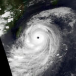
Typhoon Melissa

On September 10, a monsoon depression formed in the central Pacific, which had previously absorbed the remains of Hurricane Kristy. By September 11, the system had become well enough organized to be considered a tropical storm. Strong cross equatorial winds steered Melissa to the northeast and led to rapid intensification. Melissa gained typhoon intensity on September 13, and became a super typhoon on September 14. The cyclone then turned northwest and Melissa considerably weakened, becoming a weak tropical storm by September 18. On September 19, Melissa rounded the subtropical ridge axis and recurved, becoming a large extratropical cyclone on September 21 and dissipated, affecting Canada and Alaska on September 23.[32] In Japan, three were killed during Melissa's passage near the country.[1]
Tropical Depression Yaning

A few days after Luke impacted northern Philippines, an area of thunderstorms formed from the ITCZ, which has been enhanced by Typhoon Melissa. A new, weak low-level circulation started to develop within that area, several kilometers east of Visayas, Philippines on September 12. PAGASA issued warnings on the system, upgrading it to a tropical depression and naming it Yaning on September 13. Yaning moved in a south-southwestward direction. The next day, it started to weaken due to land reaction. Later that day, Yaning dissipated.
Tropical Storm Nat


Nat formed from an area of thunderstorms which formed along a trough trailing from Melissa. First noted on September 14, the system developed into a tropical depression and tropical storm on September 15. At this point in its life cycle it approached Guam from the west, when a squall line moved across the island, bringing wind gusts to 48 knots (89 km/h). One person drowned when knocked into the ocean, while 24 were injured, most of which due to a lightning strike which occurred in the wake of Nat along its trailing surface trough. Nat continued moving east to northeast initially before turning to the northwest by September 19, then turned back to the northeast by September 21, eventually dissipating in the subtropical western Pacific Ocean.[32]
Typhoon Orchid (Aning)


A tropical disturbance formed east of the Philippines along a surface trough trailing from Nat. In the prevailing westerly flow, the disturbance moved eastward. The system organized into a tropical depression on September 18. The system turned northward, developing into a tropical storm. As it bypassed Guam to the northwest, winds gusted to 46 knots (85 km/h) on the island. Slowly turning towards the northwest, and ultimately southwest around a monsoon gyre, Orchid slowly intensified into a typhoon. On September 22, Orchid turned northwest and continued to strengthen, peaking as a super typhoon on September 25. Slowly weakening thereafter, Orchid began to slow during recurvature as it rounded the western side of the subtropical ridge. Acceleration to the north-northeast began on September 28, and by late on September 29, Orchid made landfall in Japan as a typhoon, crossing Honshu and western Hokkaido. Winds gusted to 92 knots (170 km/h) at Tanabe. Rainfall from Orchid across central Japan was beneficial, as it helped relieve drought conditions.[32] Nine perished during Orchid's passage across Japan.[1]
Typhoon Pat

Pat formed on the east end of the monsoon trough as a tropical disturbance on September 20 near Wake Island, moving west-southwest. The system organized into a tropical depression on September 21. Turning to the northwest, Pat quickly strengthened into a typhoon by September 23. Soon afterward, Typhoon Pat turned westward and weakened, beginning its interaction with Tropical Storm Ruth located to Pat's southwest. On September 24, Pat and Ruth began to orbit around each other, entrapped within a Fujiwhara interaction. By the morning of September 26, the two cyclones merged and both systems' thunderstorm activity fell apart, a condition which continued after the merger. Over the next couple days, the merged cyclone regained central convection and recurved east of Japan.[32]
Tropical Storm Ruth

An area of thunderstorm activity formed between Orchid and Pat on September 23. The system developed, becoming Tropical Depression 30W on September 24. A day later, the cyclone achieved tropical storm strength. Ruth moved northeast within a general southwest flow regime, as the smaller tropical cyclone named Pat approached from the northeast. By September 26, the two cyclones merged, and the resultant cyclone recurved east of Japan.[32]
Tropical Depression 31W


On September 26, an upper-tropospheric circulation separated from an upper-level trough that was situated northwest of Hawaii, and began moving westward towards the International Date Line. This tropical upper tropospheric trough also had deep convection associated with low-level cloud lines, which suggested that a low-level circulation possibly existed.[39] It crossed the Dateline on September 27, with the convection persisting. The system continued to organise and became a tropical depression the next day, despite lacking in deep convection.[39] The depression never strengthened into a tropical storm, and lacked deep convection for most of its existence. It recurved eastward and weakened on October 3, and the final warning was issued. No damage or casualties were reported.[39]
Typhoon Seth (Bidang)

An area of thunderstorm activity formed near the Marshall Islands, moving westward in a regime which showed an atypically weak monsoon trough. On October 1, a low level circulation developed in association with the convection. Slow development occurred, and the system strengthened into a tropical depression on October 3. Winds gusted to 41 knots (76 km/h) as Seth passed south of Guam on October 5. Developing at a modest pace as it moved west-northwest, the cyclone strengthened into a typhoon on October 6. Seth strengthened into a strong typhoon on October 7, recurving around the periphery of the subtropical ridge, missing Taiwan to the east. Heavy rainfall and high winds across the island led to eight deaths, and NT$60 million (1994 dollars), or $2.3 million (1994 USD),[18] in damage.[1]
As it moved through the Ryukyu Islands, winds gusted to 110 knots (200 km/h) Yonaguni Jima. The cyclone accelerated as it approached Korea as a typhoon which had begun to transition into a nontropical low. At Cheju Do, winds peaked at 78 knots (144 km/h) as Seth passed by. Rainfall amounts measured across South Korea were in excess of 300 millimetres (12 in). Although the rainfall generally relieved drought conditions, one person perished due to flooding in Samchok. Seth become an extratropical cyclone soon after crossing the peninsula on October 12.[32]
Typhoon Teresa (Katring)


Typhoon Teresa (named Katring by PAGASA)[23] was at one point one of four tropical cyclones that existed simultaneously in the Western North Pacific, and it was the westernmost of the four.[40] This system was first noted as a tropical disturbance on October 15 while about 550 kilometres (340 mi) east of the southern Mariana Islands. The system moved west and passed north of Guam near Saipan on October 16 at around 0600 UTC.[40]
Slowly organizing, the system evolved into Tropical Depression 34W early on October 16,[40] and a tropical storm later in the day.[7] Teresa continued moving westward at a constant pace and intensified into a typhoon on October 19, reaching its peak intensity of 80 knots (150 km/h) that same day.[40] Teresa crossed the central Philippines on a west-southwestward track, passing just south of Manila. It had weakened to a severe tropical storm by the time it exited the Philippine islands. The storm continued on a southwestward motion, slowly re-intensifying, and it had regained typhoon strength by October 23.[7][40] The storm then slowed and turned toward the west, and slowly weakened as it moved towards the coast of Vietnam. The final warning was issued by the JTWC when Teresa was still a tropical storm, but weakening over water east of Vietnam. The remnants of Teresa made landfall in southern Vietnam late on October 26.[40]
Teresa left at least 14 dead and 11 injured in the Philippines,[23] and caused heavy damage to rice and coconut plantations. Electricity was cut off in Manila and surrounding areas.[1] Trees were also reported uprooted, and utility poles brought down.[40] A Maltese oil tanker[40] located in the South China Sea about 600 kilometres (370 mi) southeast of Hong Kong split into two and capsized, killing two and leaving 14 missing.[1] The other crew members were rescued.[40] Typhoon Teresa caused a total of $67.4 million (1994 USD) in damage in Laguna, Batangas, Rizal and Cavite Provinces in the Philippines.[23]
Typhoon Verne (Delang)


An area of organized thunderstorm activity formed on October 14 in the Marshall Islands. Late on October 15, the system formed into a tropical depression. The system slowly developed as it moved west-northwest, becoming a tropical storm on October 18. The system passed north of Guam, bringing over 75 millimetres (3.0 in) of rainfall to much of the island, and winds gusted up to 60 knots (110 km/h). By October 20, Verne had developed into a typhoon. Late on October 21, steering currents collapsed, and Verne stalled for nearly a week. Verne became a strong typhoon on October 24. Turning northward on October 26, the system slowly weakened east of mainland Asia, and on October 28 Verne weakened back into a tropical storm. On November 1, Verne became an extratropical cyclone as it moved east of Japan.[32]
Typhoon Wilda

Forming along the trough axis in which Teresa and Verne, a tropical disturbance formed on October 18 in the central tropical Pacific. The system slowly developed, becoming a tropical depression on October 19. The depression moved west-northwestward, becoming a tropical storm on October 20. After becoming a typhoon, Wilda turned west-southwest towards Saipan. From late on October 24 through late on October 25, Wilda stalled 170 kilometres (110 mi) east-northeast of Saipan, slowly weakening. Up to 4.95 inches (126 mm) fell across the central portion of Guam while winds gusted to 74 knots (137 km/h) as Wilda stalled to the northeast. The system then turned northeast along the now reverse-oriented monsoon trough due to a weakness in the subtropical ridge to its north until October 28, before bending back to the north-northwest. Late on October 29, Wilda turned back to the northeast and began to accelerate, with the system evolving into an extratropical cyclone on November 1.[32]
Tropical Storm Yuri


On October 22, an area of convection formed northwest of Hawaii in association with a tropical upper tropospheric trough. Moving rapidly westward, the low-level circulation center associated with the convective clouds crossed the International Date Line later that day. The first mention of this system by the Joint Typhoon Warning Center in their Significant Tropical Weather Advisory six hours later noted that the low-level circulation had been developing under the TUTT cell. Slowly developing, on October 23, the system organized into Tropical Depression 36W.[41] The Japan Meteorological Agency upgraded the system to Tropical Storm 9433 at 1200 UTC that day,[7] shortly before the JTWC decided to upgrade the depression to Tropical Storm Yuri. The JTWC upgrade was based on a small area of deep convection which had formed to the southeast of the low-level centre, as well as a rapid low-level cloud motion of 40 knots (74 km/h) that was observed to the north of the circulation.[41]
Yuri remained a minimal tropical storm for the next two days or so before it was downgraded to a tropical depression because of a lack of deep convection and a weakening in its appearance on satellite imagery. The final warning was issued a few hours later on October 25.[41] There were no reports of damage or injuries. A weak wind of 11 knots (20 km/h) associated with the dissipating system was recorded at Chichi-jima on October 25.[42]
Typhoon Zelda (Esang)


The northeastern end of the monsoon trough developed into Tropical Depression 37W on October 25 over subtropical latitudes. It headed southeastward, then turned to the southwest, becoming a tropical storm on the 29th. Zelda continued its slow intensification rate, and as it turned more westward, it became a typhoon on the 1st. Continuing its clockwise movement, Zelda turned to the northwest, where it passed over the Northern Mariana Islands. On the 3rd the storm rapidly intensified to a 135 kn (250 km/h) super typhoon, and as it turned to the northeast it slowly weakened to a tropical storm on the 8th. On the 10th, Zelda dissipated, only 1,700 kilometres (1,100 mi) from its start after following a several thousand mile track.[32]
Typhoon Axel (Garding)

Forming along a near-equatorial trough, a surface circulation formed on December 13 and began to move west-northwestward. The system organized into a tropical depression on December 14, but only for 12 hours as the system became much less organized and had more than one circulation center. On December 15, the system began to regenerate due to increasing thunderstorm activity near its main circulation center, and by late in the day, was once again considered a tropical depression. Modestly developing thereafter, the tropical cyclone intensified into a typhoon on December 19 as it turned due west.[32]
Axel moved south of Samar in the Philippines, weakening as it moved through the archipelago. Nineteen perished as the typhoon moved through the country,[1][43] with five deaths occurring in Bacolod City as heavy rains caused a dam break. High waves destroyed 163 homes on Mindanao. Entering the South China Sea as a tropical storm, the system briefly reintensified into a typhoon before vertical wind shear substantially increased, which led to significant weakening of Axel. The tropical cyclone dissipated 370 kilometres (230 mi) southeast of Hong Kong on December 26.[32]
The remnants of Axel interacted with the remnants of Severe Tropical Storm Bobbie and created a large, long-lived extratropical system that affected Canada and dissipated on January 2, 1995.[citation needed]
Severe Tropical Storm Bobbie

Moving west-northwest, a tropical disturbance formed in the Marshall Islands on December 15. Due to vertical wind shear, the system was slow to organize. The system organized into a tropical depression on December 18, and intensified into a tropical storm on December 19. The system recurved weakened to a remnant low early on December 26.[32]
Storm names
During the season 34 named tropical cyclones developed in the Western Pacific and were named by the Joint Typhoon Warning Center, when it was determined that they had become tropical storms. These names were contributed to a revised list which started on mid-1989.
| Owen | Page | Russ | Sharon | Tim | Vanessa | Walt | Yunya | Zeke | Amy | Brendan | Caitlin | Doug | Ellie | Fred | Gladys | Harry |
| Ivy | Joel | Kinna | Luke | Melissa | Nat | Orchid | Pat | Ruth | Seth | Teresa | Verne | Wilda | Yuri | Zelda | Axel | Bobbie |
Philippines
| Akang | Bising | Klaring | Deling | Emang |
| Gading | Heling | Iliang | Loleng | Miding |
| Norming | Oyang | Pasing | Ritang | Susang |
| Tering | Uding | Weling | Yaning | |
| Auxiliary list | ||||
|---|---|---|---|---|
| Aning | ||||
| Bidang | Katring | Delang | Esang | Garding |
The Philippine Atmospheric, Geophysical and Astronomical Services Administration uses its own naming scheme for tropical cyclones in their area of responsibility. PAGASA assigns names to tropical depressions that form within their area of responsibility and any tropical cyclone that might move into their area of responsibility. Should the list of names for a given year prove to be insufficient, names are taken from an auxiliary list, the first 6 of which are published each year before the season starts. Names not retired from this list will be used again in the 1998 season. This is the same list used for the 1990 season, with the exception of Ritang, which replaced Ruping. PAGASA uses its own naming scheme that starts in the Filipino alphabet, with names of Filipino female names ending with "ng" (A, B, K, D, etc.). Names that were not assigned/going to use are marked in gray.
Season effects
This table summarizes all the systems that developed within or moved into the North Pacific Ocean, to the west of the International Date Line during 1994. The tables also provide an overview of a systems intensity, duration, land areas affected and any deaths or damages associated with the system.
| Name | Dates | Peak intensity | Areas affected | Damage (USD) |
Deaths | Refs | ||
|---|---|---|---|---|---|---|---|---|
| Category | Wind speed | Pressure | ||||||
| 01W (Akang) | January 4–5 | Tropical depression | 55 km/h (34 mph) | 1,004 hPa (29.65 inHg) | Philippines | $2.4 million | 45 | |
| Owen (Bising) | March 31 – April 9 | Severe tropical storm | 110 km/h (68 mph) | 980 hPa (28.94 inHg) | Caroline Islands, Philippines | Unknown | 10 | |
| Page (Klaring) | May 12–17 | Typhoon | 130 km/h (81 mph) | 965 hPa (28.50 inHg) | Caroline Islands | None | None | |
| 04W (Deling) | May 25–26 | Tropical depression | 55 km/h (34 mph) | 1,004 hPa (29.65 inHg) | Philippines | None | 5 | |
| TD | May 27 | Tropical depression | Not specified | 1,004 hPa (29.65 inHg) | None | None | None | |
| Russ (Emang) | June 3–9 | Severe tropical storm | 95 km/h (59 mph) | 985 hPa (29.09 inHg) | China | $728 million | 74 | |
| Sharon (Gading) | June 21–25 | Tropical storm | 75 km/h (47 mph) | 996 hPa (29.41 inHg) | Philippines, South China | $5.27 billion | 13 | |
| Heling | June 25–29 | Tropical depression | Not specified | 1,002 hPa (29.59 inHg) | Philippines, Vietnam | None | None | |
| 07W | July 3–6 | Tropical depression | 55 km/h (34 mph) | 998 hPa (29.47 inHg) | South China | $114 million | 10 | |
| Tim (Iliang) | July 7–12 | Typhoon | 175 km/h (109 mph) | 930 hPa (27.46 inHg) | Philippines, Taiwan, China | $249 million | 36 | |
| Vanessa (Loleng) | July 9–11 | Tropical storm | 75 km/h (47 mph) | 990 hPa (29.23 inHg) | Philippines | None | None | |
| Walt (Miding) | July 14–28 | Typhoon | 185 km/h (115 mph) | 915 hPa (27.02 inHg) | Philippines, Japan, South Korea | None | None | |
| Yunya (Norming) | July 17–21 | Tropical storm | 85 km/h (53 mph) | 990 hPa (29.23 inHg) | Philippines | $37.6 million | 11 | |
| Zeke | July 17–24 | Severe tropical storm | 95 km/h (59 mph) | 985 hPa (29.09 inHg) | None | None | None | |
| TD | July 18–23 | Tropical depression | Not specified | 1,000 hPa (29.53 inHg) | Vietnam, China | None | None | |
| TD | July 23–24 | Tropical depression | Not specified | 1,000 hPa (29.53 inHg) | None | None | None | |
| Amy | July 25–31 | Tropical storm | 85 km/h (53 mph) | 985 hPa (29.09 inHg) | South China, Vietnam | $8 million | 15 | |
| 13W | July 25–29 | Tropical depression | 55 km/h (34 mph) | 996 hPa (29.41 inHg) | Mariana Islands | None | None | |
| TD | July 25–26 | Tropical depression | Not specified | 998 hPa (29.47 inHg) | None | None | None | |
| Brendan (Oyang) | July 25 – August 3 | Tropical storm | 85 km/h (53 mph) | 992 hPa (29.29 inHg) | Philippines, Ryukyu Islands, Korean Peninsula | Unknown | 2 | |
| Caitlin (Pasing) | July 28 – August 6 | Tropical storm | 85 km/h (53 mph) | 990 hPa (29.23 inHg) | Mariana Islands, Philippines, Taiwan, China | $643 million | 18 | |
| TD | July 29 | Tropical depression | Not specified | 1,004 hPa (29.65 inHg) | None | None | None | |
| Doug (Ritang) | August 1–13 | Typhoon | 185 km/h (115 mph) | 925 hPa (27.32 inHg) | Mariana Islands, Philippines, Taiwan, Ryukyu Islands, South Korea, East China | $110 million | 26 | |
| Ellie | August 6–16 | Typhoon | 150 km/h (93 mph) | 965 hPa (28.50 inHg) | Japan, East China, Russia | None | None | |
| Li | August 12–17 | Tropical storm | 85 km/h (53 mph) | 992 hPa (29.29 inHg) | None | None | None | |
| Fred (Susang) | August 14–23 | Typhoon | 185 km/h (115 mph) | 925 hPa (27.32 inHg) | Japan, Taiwan, East China, Russia | $875 million | 1,000 | |
| Gladys (Uding) | August 20 – September 4 | Typhoon | 150 km/h (93 mph) | 955 hPa (28.20 inHg) | Taiwan, Ryukyu Islands, East China | $15.4 million | 6 | |
| Harry | August 23–29 | Tropical storm | 85 km/h (53 mph) | 990 hPa (29.23 inHg) | Philippines, South China, Vietnam | $56.5 million | None | |
| Ivy | August 27 – September 4 | Typhoon | 140 km/h (87 mph) | 960 hPa (28.35 inHg) | None | None | None | |
| John | August 28 – September 8 | Typhoon | 155 km/h (96 mph) | 945 hPa (27.91 inHg) | Wake Island | None | None | |
| Tering | August 29–30 | Tropical depression | 35 km/h (22 mph) | 1,006 hPa (29.71 inHg) | None | None | None | |
| TD | September 3 | Tropical depression | Not specified | 1,008 hPa (29.77 inHg) | None | None | None | |
| Joel | September 3–6 | Tropical storm | 85 km/h (53 mph) | 990 hPa (29.23 inHg) | South China, Vietnam | None | None | |
| Kinna | September 3–12 | Typhoon | 140 km/h (87 mph) | 960 hPa (28.35 inHg) | None | None | None | |
| Luke (Weling) | September 7–14 | Tropical storm | 85 km/h (53 mph) | 990 hPa (29.23 inHg) | Philippines, South China, Vietnam | $11.7 million | None | |
| Melissa | September 11–19 | Typhoon | 205 km/h (127 mph) | 910 hPa (26.87 inHg) | Marshall Islands, Japan | None | 3 | |
| Yaning | September 13–14 | Tropical depression | 55 km/h (34 mph) | 1,004 hPa (29.65 inHg) | None | None | None | |
| TD | September 13–14 | Tropical depression | Not specified | 1,008 hPa (29.77 inHg) | None | None | None | |
| Nat | September 15–22 | Tropical storm | 75 km/h (47 mph) | 992 hPa (29.29 inHg) | Mariana Islands | None | None | |
| Orchid (Aning) | September 17–30 | Typhoon | 185 km/h (115 mph) | 925 hPa (27.32 inHg) | Mariana Islands, Japan, Russia Far East | None | 9 | |
| Pat | September 21–28 | Typhoon | 130 km/h (81 mph) | 965 hPa (28.50 inHg) | None | None | None | |
| TD | September 23 | Tropical depression | Not specified | 1,008 hPa (29.77 inHg) | None | None | None | |
| Ruth | September 24–26 | Tropical storm | 75 km/h (47 mph) | 996 hPa (29.41 inHg) | None | None | None | |
| 31W | September 29 – October 6 | Tropical depression | 55 km/h (34 mph) | 1,000 hPa (29.53 inHg) | None | None | None | |
| Seth (Bidang) | October 3–12 | Typhoon | 205 km/h (127 mph) | 910 hPa (26.87 inHg) | Marshall Islands, Caroline Islands, Mariana Islands, Taiwan, Japan, Korean Peninsula | $2.3 million | 9 | |
| Teresa (Katring) | October 16–26 | Typhoon | 150 km/h (93 mph) | 955 hPa (28.20 inHg) | Mariana Islands, Philippines, Vietnam, Cambodia | $16.4 million | 16 | |
| Verne (Delang) | October 16 – November 1 | Typhoon | 150 km/h (93 mph) | 950 hPa (28.05 inHg) | None | None | None | |
| Wilda | October 19 – November 1 | Typhoon | 165 km/h (103 mph) | 935 hPa (27.61 inHg) | None | None | None | |
| Yuri | October 22–26 | Tropical storm | 75 km/h (47 mph) | 996 hPa (29.41 inHg) | Wake Island | None | None | |
| Zelda (Esang) | October 26 – November 7 | Typhoon | 195 km/h (121 mph) | 910 hPa (26.87 inHg) | Caroline Islands, Mariana Islands, Japan | None | None | |
| Axel (Garding) | December 16–27 | Typhoon | 155 km/h (96 mph) | 950 hPa (28.05 inHg) | Caroline Islands, Philippines | None | 19 | [43] |
| Bobbie | December 18–26 | Severe tropical storm | 95 km/h (59 mph) | 985 hPa (29.09 inHg) | Marshall Islands, Caroline Islands, Mariana Islands | None | None | |
| Season aggregates | ||||||||
| 52 systems | January 4 – December 27, 1994 | 205 km/h (127 mph) | 910 hPa (26.87 inHg) | $8.14 billion | 1301 | |||
See also
- List of Pacific typhoon seasons
- 1994 Pacific hurricane season
- 1994 Atlantic hurricane season
- 1994 North Indian Ocean cyclone season
- South-West Indian Ocean cyclone season: 1993–94, 1994–95
- Australian region cyclone season: 1993–94, 1994–95
- South Pacific cyclone season: 1993–94, 1994–95
References
- General
- 1994 Annual Tropical Cyclone Report (PDF). Joint Typhoon Warning Center (Report). United States Navy, United States Airforce. 1995. Retrieved June 25, 2014.
- Specific
- ^ a b c d e f g h i j k l m n o p q r s t u v w x y z aa ab ac ad ae af ag ah ai Royal Observatory Hong Kong (2000-05-17). "Tropical Cyclones in 1994" (PDF). Government of Hong Kong. Archived from the original (PDF) on 2006-12-30. Retrieved 2007-02-22.
- ^ a b c d Lander, Mark A; Joint Typhoon Warning Center. Tropical Depression 01W (1994 Annual Tropical Cyclone Report).
- ^ United Nations Department of Humanitarian Affairs (1994-01-13). "Philippines Tropical Storm Akang Jan 1994 UN DHA Information Report 1". ReliefWeb.
- ^ a b c d e f g h i Bill Kyle (1995). "1994 Tropical Cyclone Summary for the Western North Pacific Ocean (west of 180 degrees)" (PDF). University of Hong Kong.
- ^ a b Dartmouth Flood Observatory (2006-04-14). "1994 Global Register of Major Flood Events". Dartmouth College. Archived from the original on 2017-02-23. Retrieved 2006-09-22.
- ^ a b c d e f Mark A. Lander (1995). "Typhoon Owen (02W)" (PDF). 1994 Annual Tropical Cyclone Report. Joint Typhoon Warning Center. Archived from the original (PDF) on June 7, 2011.
- ^ a b c d e f g h i j k l m n o p q RSMC Tokyo-Typhoon Center Japan Meteorological Agency. "RSMC Best Track Data (Text) 1990–1999". Government of Japan. Archived from the original (TXT) on 2013-01-22. Retrieved 2014-06-20.
- ^ a b United Nations Department of Humanitarian Affairs (1994-04-09). "Philippines Tropical Storm Owen Apr 1994 UN DHA Information Report 1". ReliefWeb.
- ^ Asanobu Kitamoto. "Precipitation Summary View (Typhoon 199401)". National Institute of Informatics.
- ^ Asanobu Kitamoto. "Wind Summary View (Typhoon 199401)". National Institute of Informatics.
- ^ a b c d e f g h i j Mark A. Lander (1994). "Typhoon Page (03W)" (PDF). 1994 Annual Tropical Cyclone Report. Joint Typhoon Warning Center. Archived from the original (PDF) on June 7, 2011.
- ^ a b "1994 Best Track Data". Joint Typhoon Warning Center. Archived from the original (txt) on 2010-03-11. Retrieved 2010-01-01.
- ^ Asanobu Kitamoto. "Precipitation Summary View (Typhoon 199402)". National Institute of Informatics.
- ^ Asanobu Kitamoto. "Wind Summary View (Typhoon 199402)". National Institute of Informatics.
- ^ a b c Mark A. Lander (1995). "Tropical Depression 04W" (PDF). 1994 Annual Tropical Cyclone Report. Joint Typhoon Warning Center. Archived from the original (PDF) on June 7, 2011.
- ^ a b c Charles P. Guard (1995). "Tropical Storm Russ (05W)" (PDF). 1994 Annual Tropical Cyclone Report. Joint Typhoon Warning Center. Archived from the original (PDF) on June 7, 2011.
- ^ "1994 Best Track Data". Joint Typhoon Warning Center. Archived from the original on 2010-03-11. Retrieved 2010-01-01.
- ^ a b c d e f g h i j Canada.com: the Currency Sie. FXConverter Results – Currency Converter for 164 Currencies. Retrieved on 2008-11-27. Archived 2 May 2009 at the Wayback Machine
- ^ a b c d e Charles P. Guard (1995). "Tropical Storm Sharon (06W)" (PDF). 1994 Annual Tropical Cyclone Report. Joint Typhoon Warning Center. Archived from the original (PDF) on June 7, 2011.
- ^ a b c d Charles P. Guard (1995). "Tropical Depression 07W" (PDF). 1994 Annual Tropical Cyclone Report. Joint Typhoon Warning Center. Archived from the original (PDF) on June 7, 2011.
- ^ a b c d e Charles P. Guard (1995). "Typhoon Tim (08W)" (PDF). 1994 Annual Tropical Cyclone Report. Joint Typhoon Warning Center. Archived from the original (PDF) on June 7, 2011.
- ^ a b Mark A. Lander (1995). "Tropical Storm Vanessa (09W)" (PDF). 1994 Annual Tropical Cyclone Report. Joint Typhoon Warning Center. Archived from the original (PDF) on June 7, 2011.
- ^ a b c d e f "Natural Disasters in Philippines (Raw Data, 1901–2000)" (PDF). Asian Disaster Reduction Center. p. 13. Archived from the original (PDF) on September 28, 2007.
- ^ "1994 Best Track Data". Joint Typhoon Warning Center. Archived from the original on 2010-03-11. Retrieved 2010-01-01.
- ^ Joint Typhoon Warning Center. Super Typhoon Walt. Retrieved on 2007-05-19.
- ^ a b c d e f g Mark A. Lander (1995). "Tropical Storm Yunya (11W)" (PDF). 1994 Annual Tropical Cyclone Report. Joint Typhoon Warning Center. Archived from the original (PDF) on June 7, 2011. Retrieved 2006-03-18.
- ^ Joint Typhoon Warning Center. Typhoon Zeke. Retrieved on 2007-05-19.
- ^ a b c Mark A. Lander (1995). "Tropical Storm Amy (15W)" (PDF). 1994 Annual Tropical Cyclone Report. Joint Typhoon Warning Center. Archived from the original (PDF) on June 7, 2011. Retrieved 2007-03-08.
- ^ a b c Charles P. Guard (1995). "Tropical Depression 13W" (PDF). 1994 Annual Tropical Cyclone Report. Joint Typhoon Warning Center. Archived from the original (PDF) on June 7, 2011.
- ^ a b Charles P. Guard (1995). "Tropical Storm Brendan (14W)" (PDF). 1994 Annual Tropical Cyclone Report. Joint Typhoon Warning Center. Archived from the original (PDF) on June 7, 2011. Retrieved 2007-03-08.
- ^ Joint Typhoon Warning Center. Tropical Storm Caitlin. Retrieved on 2007-05-19.
- ^ a b c d e f g h i j k l m n o p q r s t Joint Typhoon Warning Center. Chapter 3: Summary of Western North Pacific and North Indian Ocean Tropical Cyclones. Archived 2011-06-07 at the Wayback Machine Retrieved on 2008-11-15.
- ^ a b National Hurricane Center; Hurricane Research Division; Central Pacific Hurricane Center (April 4, 2023). "The Northeast and North Central Pacific hurricane database 1949–2022". United States National Oceanic and Atmospheric Administration's National Weather Service. A guide on how to read the database is available here.
 This article incorporates text from this source, which is in the public domain.
- ^ a b c Guard, Charles P; Joint Typhoon Warning Center (1995). Typhoon Li (08E) (1994 Annual Tropical Cyclone Report). p. 106.
- ^ Central Pacific Hurricane Center. The 1994 Central Pacific Tropical Cyclone Season (NWSTM PR-41). United States National Oceanic and Atmospheric Administration. Retrieved June 25, 2014.
- ^ "Tropical Cyclone Weekly Summary #161 (August 28 – September 4, 1994)". Sci.geo.meteorology listserv. 1994-09-07. Retrieved 2014-08-29.
- ^ a b Mark A. Lander (1995). "Typhoon John (10E)" (PDF). 1994 Annual Tropical Cyclone Report. Joint Typhoon Warning Center. Archived from the original (PDF) on 2011-06-07.
- ^ a b c d e Charles P. Guard (1995). "Tropical Storm Joel (23W)" (PDF). 1994 Annual Tropical Cyclone Report. Joint Typhoon Warning Center. Archived from the original (PDF) on 2011-06-07. Retrieved 2007-03-08.
- ^ a b c Mark A. Lander (1995). "Tropical Depression 31W" (PDF). 1994 Annual Tropical Cyclone Report. Joint Typhoon Warning Center. Archived from the original (PDF) on 2011-06-07.
- ^ a b c d e f g h i Mark A. Lander (1995). "Typhoon Teresa (34W)" (PDF). 1994 Annual Tropical Cyclone Report. Joint Typhoon Warning Center. Archived from the original (PDF) on 2011-06-07. Retrieved 2007-03-08.[dead link]
- ^ a b c Mark A. Lander (1995). "Tropical Storm Yuri (36W)" (PDF). 1994 Annual Tropical Cyclone Report. Joint Typhoon Warning Center. Archived from the original (PDF) on 2011-06-07.[dead link]
- ^ Asanobu Kitamoto. "Wind Summary View (Typhoon 199433)". National Institute of Informatics.
- ^ a b "Manila Standard - Google News Archive Search".
External links
- Satellite movie of 1994 Pacific typhoon season
- Japan Meteorological Agency
- Joint Typhoon Warning Center Archived 2010-03-01 at the Wayback Machine
- Hong Kong Observatory
- Macau Meteorological Geophysical Services
- Philippine Atmospheric, Geophysical and Astronomical Services Administration
- Taiwan Central Weather Bureau
Tropical cyclones of the 1994 Pacific typhoon season | ||
|---|---|---|
 | ||