
 February 5 February 6 February 7 March 1 March 28 | |
| Local date | 1783 |
|---|---|
| Tsunami | Yes |
| Casualties | 32,000–50,000 |
The 1783 Calabrian earthquakes were a sequence of five strong earthquakes that hit the region of Calabria in southern Italy (then part of the Kingdom of Naples), the first two of which produced significant tsunamis. The epicenters form a clear alignment extending nearly 100 km from the Straits of Messina to about 18 km SSW of Catanzaro. The epicenter of the first earthquake occurred in the plain of Palmi. The earthquakes occurred over a period of nearly two months, all with estimated magnitudes of 5.9 or greater. Estimates of the total number of deaths lie in the range 32,000 to 50,000.[1]
YouTube Encyclopedic
-
1/5Views:24 7991 7533 78918 9481 205
-
I 5 Terremoti più potenti d'Italia
-
Calabria Earthquake زلزال كالابريا
-
Messina earthquake, the most deadly natural disaster in Europe. 28 December 1908
-
MESSINA 1908 il terremoto ( SuperQuark raiuno )
-
Earthquake hits beautiful village Preci in Italy . Preci before and after the earthquake
Transcription
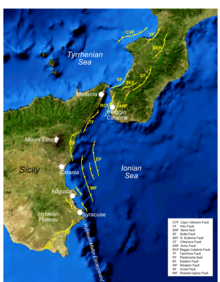
Tectonic setting
The southwestern part of Calabria and the eastern part of Sicily are areas of active crustal extension within the Siculo-Calabrian rift Zone. This 350 km long zone developed within the Apennine chain during the Pleistocene and takes up WNW–ESE directed extension.[2]
Events
February 5
This earthquake, with an estimated magnitude of 7.0, affected a large area including most of the southern Italian peninsula and shook the whole island of Sicily.[3] Many villages were damaged and as many as 180 almost completely destroyed, with more than 25,000 casualties. A tsunami affected the coastline on both sides of the Straits of Messina, destroying the harbour walls at Messina. The earthquake had already caused widespread death and destruction in Messina. Homes were razed to the ground, the medieval Duomo was badly damaged and most of the historic buildings were reduced to rubble.
Near the epicenter the ground shaking was so intense that people were knocked off their feet and heavy stones were found to be dislodged and upturned.[1] Large landslides caused major destruction at Terranova and Molochio but even well-constructed buildings not thus affected were almost completely destroyed, such as in Oppido Mamertina and Casalnuovo.[1]
The earthquake is thought to have involved rupturing of the Galatro, Cittanova and Sant'Eufemia faults, which form the southeastern boundary to the Gioia Basin.[1]
February 6
This magnitude 6.2 event occurred during the night following the first event and struck the area just to the southwest. Most of the damage and casualties appear to have been caused by a tsunami that was set off by a major collapse of Monte Pací into the sea near Scilla shortly after the earthquake.[3] Many of Scilla's residents, frightened by the tremors of the previous day had moved onto the open beach for the night, where they were overwhelmed by the waves. The tsunami caused severe flooding in the town, reaching as far as 200 m inland, and there were more than 1500 deaths.[3]
The earthquake is thought to have involved rupturing of the Scilla fault, which defines the coast around Scilla.[1]
February 7

This event occurred at about midday 40 km NE of the first mainshock on the 5th. Severe damage extended 15 km along the front of the Serre Mountains, levelling all the villages between Acquaro and Soriano Calabro.[1]
The earthquake is thought to have involved rupturing of the southern segment of the Serre fault that bounds the Mesima Basin.[1]
March 1
This earthquake was the weakest of the sequence and caused relatively little damage.[1]
The earthquake is thought to have involved rupturing of the northern segment of the Serre fault.[1]
March 28
The final event of the sequence was of similar magnitude to the first and had an epicenter about 20 km east of the fourth, near Girifalco and Borgia in the Catanzaro Basin.[1] The earthquake lasted for about ten seconds, and many villages were destroyed with many hundreds dead in Borgia, Girifalco, Maida and Cortale. Landslides were common and sand volcanoes were seen, particularly on the banks of the Amato river.[4]
This earthquake has not been tied to a particular fault, but a recent re-evaluation of the intensity data indicates that the isoseismal areas are elongated NE–SW, suggesting faulting of similar trend to that observed for the other earthquakes in the sequence.[5]
Summary of earthquakes
The earthquake parameters shown below are taken from the CFTI4 online catalogue.[6] The epicentral locations are here related to the nearest large village or town.
| Location | Date | Time | Coordinates | Magnitude | Intensity |
|---|---|---|---|---|---|
| near Oppido Mamertina | February 5 | 12:00 | 38°18′N 15°58′E / 38.30°N 15.97°E | 7.0 | XI |
| 7 km NE of Messina | February 6 | 00:20 | 38°13′N 15°38′E / 38.22°N 15.63°E | 6.2 | VIII–IX |
| 3 km SW of Soriano Calabro | February 7 | 13:10 | 38°35′N 16°12′E / 38.58°N 16.20°E | 6.6 | X |
| 2 km SE of Filadelfia | March 1 | 01:40 | 38°46′N 16°18′E / 38.77°N 16.30°E | 5.9 | IX |
| near Girifalco | March 28 | 18:55 | 38°47′N 16°28′E / 38.78°N 16.47°E | 7.0 | X |
Relationship between earthquakes
All the earthquakes in this sequence are thought to be linked by a process of triggering caused by stress redistribution following each individual event.[1]
See also
References
- ^ a b c d e f g h i j k Jacques, E.; Monaco C.; Tapponnier P.; Tortorici L. & Winter T. (2002). "Faulting and earthquake triggering during the 1783 Calabria seismic sequence". Geophysical Journal International. 147 (3): 499–516. Bibcode:2001GeoJI.147..499J. doi:10.1046/j.0956-540x.2001.01518.x.
- ^ Catalano, S.; De Guidi, G.; Monaco, C.; Tortorici, G. & Tortorici, L. (2008). "Active faulting and seismicity along the Siculo–Calabrian Rift Zone (Southern Italy)". Tectonophysics. 453 (1–4): 177–192. Bibcode:2008Tectp.453..177C. doi:10.1016/j.tecto.2007.05.008.
- ^ a b c Maramai, A.; Graziani, L.; Tinti, S. (2006). "A revision of the 1783–1784 Calabrian (southern Italy) tsunamis" (PDF). Nat. Hazards Earth Syst. Sci. 6 (6): 1053–1060. Bibcode:2006NHESS...6.1053G. doi:10.5194/nhess-6-1053-2006.
- ^ Translation of the Count Francesco Ippolito's letter to Sir William Hamilton, Knight of the Bath, F.R.S., giving an account of the earthquake which happened in Calabria, March 28, 1783. From the Appendix to the 73rd Vol. of Philosophical Transactions. The Annual Register, or a view of the History, Politics and Literature, for the year 1783
- ^ Somma, R. (2004). The 28 March 1783 earthquake (Catanzaro Graben, Southern Italy): the seismogenic structure within the seismic hazard evaluation, 1st International Conference of Applied Geophysics for Engineering
- ^ "Online catalogue of strong earthquakes in Italy 461 BC to 1997 and Mediterranean area 760 BC to 1500". Archived from the original on 2017-02-17. Retrieved 2015-02-07.
Further reading
- Graziani, L.; Maramai, A.; Tinti, S. (2006), "A revision of the 1783–1784 Calabrian (southern Italy) tsunamis" (PDF), Natural Hazards and Earth System Sciences, 6 (6): 1053–1060, Bibcode:2006NHESS...6.1053G, doi:10.5194/nhess-6-1053-2006