
Środa County
Powiat średzki | |
|---|---|
 Flag  Coat of arms | |
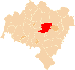 Location within the voivodeship | |
| Country | |
| Voivodeship | Lower Silesian |
| Seat | Środa Śląska |
| Gminas | |
| Area | |
| • Total | 703.68 km2 (271.69 sq mi) |
| Population (2019-06-30[1]) | |
| • Total | 54,646 |
| • Density | 78/km2 (200/sq mi) |
| • Urban | 9,516 |
| • Rural | 45,130 |
| Car plates | DSR |
| Website | http://www.powiat-sredzki.pl |
Środa County (/ˈʃroʊdə ˈʃlɒ̃skə/; Polish: powiat średzki [ˈpɔvjat ˈɕrɛt͡skʲi]) is a unit of territorial administration and local government (powiat) in Lower Silesian Voivodeship, south-western Poland. It came into being on January 1, 1999, as a result of the Polish local government reforms passed in 1998. The county covers an area of 703.7 square kilometres (271.7 sq mi). Its administrative seat and only town is Środa Śląska.
As at 2019 the total population of the county is 54,646, out of which the population of Środa Śląska accounts for 9,516, while the rural population is 45,130.
Neighbouring counties
Środa County is bordered by Wołów County to the north, Trzebnica County to the north-east, the city of Wrocław and Wrocław County to the east, Świdnica County to the south, and Jawor County and Legnica County to the west.
Administrative division
The county is subdivided into five gminas (one urban-rural and four rural). These are listed in the following table, in descending order of population.
| Gmina | Type | Area (km²) |
Population (2019) |
Seat |
| Gmina Środa Śląska | urban-rural | 214.9 | 19,862 | Środa Śląska |
| Gmina Miękinia | rural | 179.5 | 16,603 | Miękinia |
| Gmina Kostomłoty | rural | 146.3 | 7,142 | Kostomłoty |
| Gmina Malczyce | rural | 52.6 | 5,957 | Malczyce |
| Gmina Udanin | rural | 110.7 | 5,082 | Udanin |
References
- ^ "Population. Size and structure and vital statistics in Poland by territorial division in 2019. As of 30th June". stat.gov.pl. Statistics Poland. 2019-10-15. Retrieved 2020-02-14.
Seat: Środa Śląska | ||
| Urban-rural gmina |  | |
| Rural gminas | ||
| City counties |
|  |
|---|---|---|
| Land counties | ||
External links
51°09′N 16°35′E / 51.150°N 16.583°E