
Điện Biên province
Tỉnh Điện Biên | |
|---|---|
          Relic Battle of Điện Biên Phủ • View of the mountains on way from Điện Biên Phủ to Sơn La • Mường Lay skyline • Field in Điện Biên Phủ City • A Water stream in Mường Chà • Phadin Hotel • The local community center in Mường Chà | |
|
Seal | |
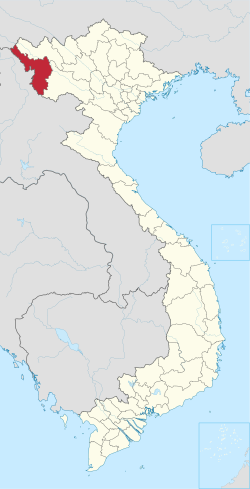 Location of Điên Biên within Vietnam | |
 | |
| Coordinates: 21°23′N 103°1′E / 21.383°N 103.017°E | |
| Country | |
| Region | Northwest |
| Capital | Điên Biên Phủ |
| Subdivision | 1 city, 8 rural districts and one town |
| Government | |
| • Type | Province |
| • Body | Điện Biên Provincial People's Council |
| • Chairman of People's Council | Mùa A Sơn |
| • Chairman of People's Committee | Lê Thành Đô |
| Area | |
| • Province | 9,541.25 km2 (3,683.90 sq mi) |
| Population (2021)[3] | |
| • Province | 615,500 |
| • Density | 65/km2 (170/sq mi) |
| • Urban | 90,300 |
| Ethnic groups | |
| • Mông | 38.12% |
| • Thái | 35.69% |
| • Vietnamese[4] | 17.38% |
| • Khơ Mú | 3.30% |
| • Dao | 1.11% |
| • Others | 4.4% |
| GDP[5] | |
| • Province | VND 15.750 trillion US$ 0.684 billion |
| Time zone | UTC+7 (ICT) |
| Area codes | 215 |
| ISO 3166 code | VN-71 |
| Website | www |
Điện Biên (Vietnamese: [ʔɗiən˧˨ʔ ʔɓiən˧˧] ⓘ) is a province in the Northwest region of Vietnam. It is bordered by Lai Châu to the northeast, Sơn La to the southeast, Pu'er City, Yunnan, China, to the northwest, and Phongsaly province in Laos to the west. The province covers an area of 9,541 square kilometres and as of 2019 it had a population of 598,856 people.[3]
YouTube Encyclopedic
-
1/5Views:49 2111 9043 671760437 128
-
Hành trình từ TP.Điện Biên đi Mường Nhé trên cung đường 200km đến Cực Tây ngã ba biên giới A Pa Chải
-
Tuan Giao district township Điện Biên Province Vietnam
-
Ben Xe Tuan Giao district Điện Biên Province
-
Muong Lay Dien Bien province Vietnam
-
Dien Bien Phu: Hell Rains Down in the Land of Heaven
Transcription
History
The name "Điện Biên" means "stable frontier" (referring to Điện Biên's location on the border between Lan Xang and Vietnam).[6] Điện Biên has various ancient monuments including the caves Thẩm Khương, as well as Thẩn Búa in Tuần Giáo. The original settlers were the Ai Lao or Tai people who are a direct ancestor of Lao people in Laos today. The names of some villages and towns still use words of Tai origin, such as Mường (city) and Tham (cave).
In the 9th and 10th centuries, the Lự in Mường Thanh were the most developed in the area and controlled Sìn Hồ, Mường Lay, and Tuần Giáo.
In the 11th and 12th centuries, Tai people (not to be confused with the Thai people of Thailand) from Mường Ôm and Mường Ai occupied Mường Lò in Nghĩa Lộ and Mường Thanh in Điện Biên. They eventually gained control of the whole area between Mường Lò and Mường Thanh (Điện Biên).
Places
Chua ta cave: Located at an altitude of nearly 1,000m above sea level, in a limestone mountain range with a geological tectonic process of millions of years, Tham Khen cave in Muong Dun commune, Tua Chua district has also been recognized by the Ministry of Culture. Sports and Tourism ranked national relics and scenic spots according to decision No. 3086/QD-BVHTTDL dated October 27, 2020. In addition to being unique like other caves, Chua Ta cave also has two typical types of ecosystems: Limestone mountain ecosystem and cave ecosystem. This place converges the diverse properties of nature.[7]
Climate
Điện Biên province has a humid subtropical climate (Köppen Cwa).
| Climate data for Điện Biên Phủ | |||||||||||||
|---|---|---|---|---|---|---|---|---|---|---|---|---|---|
| Month | Jan | Feb | Mar | Apr | May | Jun | Jul | Aug | Sep | Oct | Nov | Dec | Year |
| Record high °C (°F) | 32.4 (90.3) |
35.0 (95.0) |
36.1 (97.0) |
38.5 (101.3) |
38.6 (101.5) |
37.9 (100.2) |
36.0 (96.8) |
36.0 (96.8) |
35.0 (95.0) |
35.5 (95.9) |
34.0 (93.2) |
31.1 (88.0) |
38.6 (101.5) |
| Mean daily maximum °C (°F) | 23.8 (74.8) |
26.2 (79.2) |
29.0 (84.2) |
31.0 (87.8) |
31.7 (89.1) |
31.1 (88.0) |
30.4 (86.7) |
30.4 (86.7) |
30.5 (86.9) |
29.2 (84.6) |
26.7 (80.1) |
23.9 (75.0) |
28.6 (83.5) |
| Daily mean °C (°F) | 16.5 (61.7) |
18.3 (64.9) |
21.0 (69.8) |
23.8 (74.8) |
25.5 (77.9) |
26.3 (79.3) |
25.9 (78.6) |
25.6 (78.1) |
24.9 (76.8) |
22.9 (73.2) |
19.7 (67.5) |
16.5 (61.7) |
22.2 (72.0) |
| Mean daily minimum °C (°F) | 12.5 (54.5) |
13.5 (56.3) |
15.8 (60.4) |
19.3 (66.7) |
21.7 (71.1) |
23.4 (74.1) |
23.3 (73.9) |
23.0 (73.4) |
21.7 (71.1) |
19.4 (66.9) |
15.7 (60.3) |
12.4 (54.3) |
18.5 (65.3) |
| Record low °C (°F) | −1.3 (29.7) |
4.8 (40.6) |
5.3 (41.5) |
11.6 (52.9) |
14.8 (58.6) |
17.4 (63.3) |
18.7 (65.7) |
10.7 (51.3) |
14.2 (57.6) |
7.7 (45.9) |
4.0 (39.2) |
0.4 (32.7) |
−1.3 (29.7) |
| Average precipitation mm (inches) | 26.0 (1.02) |
30.3 (1.19) |
64.1 (2.52) |
133.8 (5.27) |
222.9 (8.78) |
305.3 (12.02) |
359.6 (14.16) |
324.8 (12.79) |
168.6 (6.64) |
71.7 (2.82) |
44.1 (1.74) |
26.0 (1.02) |
1,784.3 (70.25) |
| Average rainy days | 5.7 | 5.4 | 7.5 | 13.7 | 17.9 | 22.0 | 24.4 | 22.3 | 15.6 | 10.1 | 6.8 | 4.6 | 155.9 |
| Average relative humidity (%) | 82.4 | 80.2 | 80.2 | 81.7 | 82.2 | 83.9 | 86.4 | 87.5 | 86.3 | 84.2 | 83.1 | 83.1 | 83.4 |
| Mean monthly sunshine hours | 159.8 | 177.3 | 198.4 | 202.0 | 202.3 | 141.3 | 132.7 | 148.6 | 168.4 | 170.5 | 160.5 | 160.0 | 2,025.4 |
| Source: Vietnam Institute for Building Science and Technology[8] | |||||||||||||
| Climate data for Pha Din | |||||||||||||
|---|---|---|---|---|---|---|---|---|---|---|---|---|---|
| Month | Jan | Feb | Mar | Apr | May | Jun | Jul | Aug | Sep | Oct | Nov | Dec | Year |
| Record high °C (°F) | 29.3 (84.7) |
31.8 (89.2) |
36.0 (96.8) |
36.5 (97.7) |
36.6 (97.9) |
35.5 (95.9) |
36.0 (96.8) |
29.9 (85.8) |
32.6 (90.7) |
31.4 (88.5) |
31.2 (88.2) |
29.1 (84.4) |
36.6 (97.9) |
| Mean daily maximum °C (°F) | 17.2 (63.0) |
19.6 (67.3) |
22.7 (72.9) |
25.0 (77.0) |
25.2 (77.4) |
24.6 (76.3) |
24.2 (75.6) |
24.5 (76.1) |
24.2 (75.6) |
22.4 (72.3) |
19.7 (67.5) |
17.1 (62.8) |
22.1 (71.8) |
| Daily mean °C (°F) | 12.5 (54.5) |
14.5 (58.1) |
17.7 (63.9) |
20.0 (68.0) |
20.7 (69.3) |
20.8 (69.4) |
20.6 (69.1) |
20.6 (69.1) |
20.0 (68.0) |
18.1 (64.6) |
15.2 (59.4) |
12.4 (54.3) |
17.7 (63.9) |
| Mean daily minimum °C (°F) | 9.8 (49.6) |
11.3 (52.3) |
14.3 (57.7) |
16.6 (61.9) |
17.9 (64.2) |
18.7 (65.7) |
18.7 (65.7) |
18.6 (65.5) |
17.7 (63.9) |
15.8 (60.4) |
12.7 (54.9) |
10.0 (50.0) |
15.2 (59.4) |
| Record low °C (°F) | −4.3 (24.3) |
0.1 (32.2) |
−0.1 (31.8) |
5.9 (42.6) |
11.0 (51.8) |
13.1 (55.6) |
14.0 (57.2) |
15.0 (59.0) |
10.9 (51.6) |
8.3 (46.9) |
4.2 (39.6) |
−1.2 (29.8) |
−4.3 (24.3) |
| Average precipitation mm (inches) | 70.2 (2.76) |
73.5 (2.89) |
104.5 (4.11) |
213.4 (8.40) |
340.6 (13.41) |
381.4 (15.02) |
461.0 (18.15) |
451.9 (17.79) |
303.1 (11.93) |
201.3 (7.93) |
106.3 (4.19) |
65.7 (2.59) |
2,779.6 (109.43) |
| Average rainy days | 16.3 | 16.3 | 15.7 | 17.9 | 22.2 | 24.4 | 25.6 | 23.4 | 19.8 | 18.6 | 13.8 | 13.5 | 228.1 |
| Average relative humidity (%) | 81.4 | 75.8 | 71.1 | 75.5 | 83.0 | 89.7 | 91.4 | 90.5 | 86.9 | 86.0 | 83.9 | 81.9 | 83.2 |
| Mean monthly sunshine hours | 179.7 | 172.6 | 205.9 | 213.4 | 192.5 | 119.7 | 125.6 | 140.5 | 162.4 | 164.9 | 162.7 | 180.9 | 2,019.9 |
| Source: Vietnam Institute for Building Science and Technology[8] | |||||||||||||
Administrative divisions
Điện Biên is subdivided into 10 district-level sub-divisions:
| Second Tier subdivisions |
Area (km²) |
Third Tier subdivisions | ||
|---|---|---|---|---|
| Ward | Township | Commune | ||
| Điện Biên Phủ city | 64.27 | 7 | 2 | |
| Mường Lay town | 114.03 | 2 | 1 | |
| Điện Biên District | 1639.85 | 25 | ||
| Điện Biên Đông District | 1206.39 | 1 | 13 | |
| Mường Ảng District | 443.52 | 1 | 9 | |
| Mường Chà District | 1199.42 | 1 | 11 | |
| Mường Nhé District | 1573.73 | 11 | ||
| Nậm Pồ District | 1498.00 | 15 | ||
| Tủa Chùa District | 679.41 | 1 | 11 | |
| Tuần Giáo District | 1136.29 | 1 | 18 | |
They are further subdivided into five commune-level towns (or townlets), 116 rural communes, and nine wards.
Places in Điện Biên
References
- ^ "Phê duyệt và công bố kết quả thống kê diện tích đất đai của cả nước năm 2018" [Announcements of area statistics for the whole country in 2018]. Act No. 2908/QĐ-BTNMT of November 13, 2019 (in Vietnamese). Ministry of Natural Resources and Environment (Vietnam). - the data in the report are in hectares, rounded to integers
- ^ "STATISTICAL YEARBOOK 2019". General Statistics Office of Vietnam. 2020-06-30.
- ^ a b c General Statistics Office of Vietnam (2019). "Completed Results of the 2019 Viet Nam Population and Housing Census" (PDF). Statistical Publishing House (Vietnam). ISBN 978-604-75-1532-5.
- ^ Also called Kinh people
- ^ "Tình hình kinh tế, xã hội Điện Biên năm 2018". UBND tỉnh Điện Biên. Retrieved 10 May 2020.
- ^ "Điện Biên, hành trình trở về cội nguồn" (in Vietnamese).
- ^ "CHU HRENG MOUNTAIN – AN ATTRACTIVE DESTINATION FOR KON TUM YOUTH". Kontumtourism. 2021.
- ^ a b "Vietnam Institute for Building Science and Technology" (PDF).
External links
Places adjacent to Điện Biên province | ||||||||||||||||
|---|---|---|---|---|---|---|---|---|---|---|---|---|---|---|---|---|
| ||||||||||||||||
| International | |
|---|---|
| National | |