
Última Esperanza
Provincia de Última Esperanza | |
|---|---|
 Torres del Paine National Park | |
 Seal | |
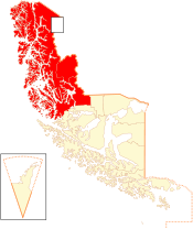 Location in the Magallanes and Antartica Chilena Region | |
 Última Esperanza Location in Chile | |
| Coordinates: 50°47′S 74°06′W / 50.783°S 74.100°W | |
| Country | |
| Region | |
| Capital | Puerto Natales |
| Communes | Puerto Natales Torres del Paine |
| Government | |
| • Type | Provincial |
| • Provincial Presidential Delegate | Ericka Farías Guerra |
| Area | |
| • Total | 55,443.9 km2 (21,407.0 sq mi) |
| Population (2012 Census)[2] | |
| • Total | 18,685 |
| • Rank | 2 |
| • Density | 0.34/km2 (0.87/sq mi) |
| • Urban | 16,978 |
| • Rural | 2,877 |
| Sex | |
| • Men | 10611 |
| • Women | 9244 |
| Time zone | UTC-3 (CLST[3]) |
| • Summer (DST) | UTC-3 (CLST[4]) |
| Area code | 61 |
| Website | Government of Última Esperanza |
Última Esperanza (Spanish: Provincia de Última Esperanza, meaning "Province of the Last Hope") is one of four provinces in the southern Chilean region of Magallanes and Antártica Chilena. The capital is Puerto Natales and it is named after Última Esperanza Sound. A section of its border with Argentina in the Southern Patagonian Ice Field is under dispute.[5]
YouTube Encyclopedic
-
1/3Views:1 0911 136299 125
-
Chile Fjord Última Esperanza
-
L'expédition Ultima Esperanza 1997
-
Chile/Chile Song/Chile Geography/Chile Country
Transcription
Administration
As a province, Última Esperanza is a second-level administrative division of Chile, which is further divided into two communes (comunas): Puerto Natales and Torres del Paine. The province is administered by a presidentially appointed governor. Ana Ester Mayorga Bahamonde was appointed governor by president Sebastián Piñera.[1]
Noted features
Within this province, the noted Torres del Paine National Park, Cerro Torre and Cerro Chaltén is located, comprising some of the most spectacular mountain peaks of South America. Also part of the biggest non-polar glacier, the Southern Patagonian Ice Field is within Última Esperanza. Cueva del Milodón Natural Monument, where prehistoric human occupation has been documented,[6] is also within this province.
References
- ^ a b "Gobierno de Chile: Gobernadores". Government of Chile (in Spanish). Retrieved 18 March 2011.
- ^ a b (in Spanish) Instituto Nacional de Estadísticas
- ^ "Chile Time". WorldTimeZones.org. Retrieved 2010-07-28.
- ^ "Chile Summer Time". WorldTimeZones.org. Retrieved 2010-07-28.
- ^ "Border agreement between Chile and Argentina". Archived from the original on 2007-01-17. Retrieved 2006-10-27.
- ^ C. Michael Hogan, Cueva del Milodon, Megalithic Portal, 13 April 2008 [1]
Communes and municipalities in Magallanes y la Antártica Chilena Region | ||
|---|---|---|
| Última Esperanza |  | |
| Magallanes | ||
| Tierra del Fuego | ||
| Antártica Chilena | ||
| International | |
|---|---|
| National | |