Watkins, Colorado | |
|---|---|
 Watkins, looking west along Colfax Avenue. | |
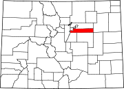
 Location of the Watkins CDP in Adams County and Arapahoe County, Colorado. | |
Location of the Watkins CDP in the United States. | |
| Coordinates: 39°41′54″N 104°34′38″W / 39.6984001°N 104.5772327°W[1] | |
| Country | |
| State | |
| Counties | Adams & Arapahoe |
| Government | |
| • Type | unincorporated town |
| Area | |
| • Total | 24.753 sq mi (64.109 km2) |
| • Land | 24.753 sq mi (64.109 km2) |
| • Water | 0 sq mi (0.0002 km2) |
| Population | |
| • Total | 682 |
| • Density | 28/sq mi (11/km2) |
| Time zone | UTC-7 (MST) |
| • Summer (DST) | UTC-6 (MDT) |
| ZIP Code[4] | 80137 |
| Area codes | 303 & 720 |
| GNIS feature[2] | Watkins CDP |
Watkins (also called Box Elder) is an unincorporated town and a census-designated place (CDP) located in and governed by Arapahoe and Adams counties, Colorado, United States. The CDP is a part of the Denver–Aurora–Lakewood, CO Metropolitan Statistical Area. The town is surrounded by Aurora and its post office, which lies within the Aurora city limits, has the ZIP Code 80137.[4] At the United States Census 2020, the population of the Watkins CDP was 682.[3]
History
The Watkins post office has been in operation since 1878.[5] The community was named after L. A. Watkins, a cattleman.[6] Long an unincorporated community, Watkins incorporated as a town on June 15, 2004.[7] However, on November 7, 2006, the town voted to revert to being an unincorporated community by a margin of 308-184.
Watkins is involved in trying to build the First Park in Adams County, and the Watkins Historical Preservation Society is co-operating with the town on some historical buildings for installation in the park as well. Colorado Air and Space Port is located near Watkins.
Geography
The Watkins CDP has an area of 15,842 acres (64.109 km2), including 0.049 acres (0.0002 km2) of water.[1]
Demographics
The United States Census Bureau initially defined the Watkins CDP for the United States Census 2010.
| Year | Pop. | ±% |
|---|---|---|
| 2010 | 653 | — |
| 2020 | 682 | +4.4% |
| Source: United States Census Bureau | ||
See also
- Outline of Colorado
- State of Colorado
References
- ^ a b c "State of Colorado Census Designated Places - BAS20 - Data as of January 1, 2020". United States Census Bureau. Retrieved December 7, 2020.
- ^ a b c "U.S. Board on Geographic Names: Domestic Names". United States Geological Survey. Retrieved December 7, 2020.
- ^ a b United States Census Bureau. "Watkins CDP, Colorado". Retrieved April 10, 2023.
- ^ a b "Look Up a ZIP Code". United States Postal Service. Retrieved December 7, 2020.
- ^ "Post offices". Jim Forte Postal History. Retrieved July 11, 2016.
- ^ Dawson, John Frank. Place names in Colorado: why 700 communities were so named, 150 of Spanish or Indian origin. Denver, CO: The J. Frank Dawson Publishing Co. p. 51.
- ^ "ALEA Fact Sheet: Arapahoe Law Enforcement Authority; What is it?" Arapahoe County, Colorado
External links
- Watkins @ Colorado.com
- Watkins @ UncoverColorado.com
- Watkins on Adams County website
- Watkins on Arapahoe County website


