
Paragon Estates, Colorado | |
|---|---|
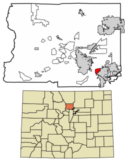 Location of the Paragon Estates CDP in Boulder County, Colorado. | |
 Paragon Estates Location of the Paragon Estates CDP in the United States. | |
| Coordinates: 39°58′49″N 105°10′53″W / 39.9801643°N 105.1812536°W[1] | |
| Country | |
| State | |
| County | Boulder County |
| Government | |
| • Type | unincorporated community |
| Area | |
| • Total | 1.684 sq mi (4.361 km2) |
| • Land | 1.676 sq mi (4.341 km2) |
| • Water | 0.008 sq mi (0.020 km2) |
| Elevation | 5,440 ft (1,658 m) |
| Population | |
| • Total | 975 |
| • Density | 580/sq mi (220/km2) |
| Time zone | UTC-7 (MST) |
| • Summer (DST) | UTC-6 (MDT) |
| ZIP Code[4] | Boulder 80303 |
| Area codes | 303 & 720 |
| GNIS feature[2] | Paragon Estates CDP |
Paragon Estates is an unincorporated community and a census-designated place (CDP) located in and governed by Boulder County, Colorado, United States. The CDP is a part of the Boulder, CO Metropolitan Statistical Area. The population of the Paragon Estates CDP was 975 at the United States Census 2020.[3] The Boulder post office (Zip Code 80303) serves the area.[4]
Geography
Paragon Estates is located in southeastern Boulder County on the northwest edge of Louisville and 6 miles (10 km) southeast of Boulder. U.S. Highway 36, the Denver–Boulder Turnpike, forms the southwest edge of the CDP.
The Paragon Estates CDP has an area of 1,078 acres (4.361 km2), including 4.9 acres (0.020 km2) of water.[1]
Demographics
The United States Census Bureau initially defined the Paragon Estates CDP for the United States Census 2010.
| Year | Pop. | ±% |
|---|---|---|
| 2010 | 928 | — |
| 2020 | 975 | +5.1% |
| Source: United States Census Bureau | ||
See also
References
- ^ a b c "State of Colorado Census Designated Places - BAS20 - Data as of January 1, 2020". United States Census Bureau. Retrieved December 12, 2020.
- ^ a b c "U.S. Board on Geographic Names: Domestic Names". United States Geological Survey. Retrieved December 12, 2020.
- ^ a b United States Census Bureau. "Paragon Estates CDP, Colorado". Retrieved April 18, 2023.
- ^ a b "Zip Code 80303 Map and Profile". zipdatamaps.com. 2020. Retrieved December 20, 2020.
External links
 Definitions from Wiktionary
 Media from Commons
 News from Wikinews
 Quotations from Wikiquote
 Texts from Wikisource
 Textbooks from Wikibooks
 Resources from Wikiversity
Municipalities and communities of Boulder County, Colorado, United States | ||
|---|---|---|
| Cities |  | |
| Towns | ||
| CDPs | ||
| Unincorporated communities | ||
| Ghost town | ||
| Footnotes | ‡This populated place also has portions in an adjacent county or counties | |