Original file (2,048 × 2,048 pixels, file size: 1.52 MB, MIME type: image/jpeg)
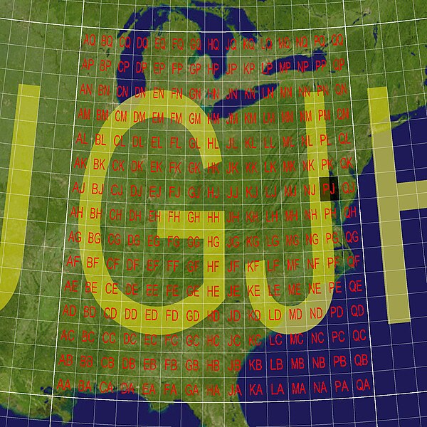
The degree grid for GEOREF for the GJ 15 degree grid square, corresponding to, roughly, the eastern United States.
| This image is ineligible for copyright and therefore is in the public domain, because it consists entirely of information that is common property and contains no original authorship. |
This graphic was created by software written specifically for the World Geographic Reference System (GEOREF) article in the Wikipedia. The background image is a Blue Marble product of NASA's Earth Observatory. It was subject to a Lambert conformal conic projection, and given appropriate markup. The observed pattern of one degree squares is present in all 15 degree squares of this grid system. The example in the GEOREF article refers to GJPJ, which has been darkened in this graphic.
 | This file is a candidate to be copied to Wikimedia Commons.
Any user may perform this transfer; refer to Wikipedia:Moving files to Commons for details. If this file has problems with attribution, copyright, or is otherwise ineligible for Commons, then remove this tag and DO NOT transfer it; repeat violators may be blocked from editing. Other Instructions
| ||
| |||
File history
Click on a date/time to view the file as it appeared at that time.
| Date/Time | Thumbnail | Dimensions | User | Comment | |
|---|---|---|---|---|---|
| current | 18:13, 20 December 2005 |  | 2,048 × 2,048 (1.52 MB) | Mdf (talk | contribs) | The GJ quad in the GEOREF grid system, which covers (roughly) the eastern United States. {{PD}} This image was constructed by software written specifically for the GEOREF article in the Wikipedia. The background image is a Blue Marble product o |
| 18:26, 19 December 2005 |  | 2,048 × 2,048 (1.5 MB) | Mdf (talk | contribs) | The degree grid for GEOREF for the GJ 15 degree grid square, corresponding to (roughly) the South-East United States. {{PD}} This graphic was created by software written specifically for the GEOREF article in the Wikipedia. The background image |
You cannot overwrite this file.
