
| Strongili | ||
|---|---|---|
| Στρογγυλή Μεγίστης | ||
 | ||
| Ubicación geográfica | ||
| Región | mar Egeo | |
| Archipiélago | Dodecaneso | |
| Mar | Mediterráneo | |
| Coordenadas | 36°06′50″N 29°38′12″E / 36.113888888889, 29.636666666667 | |
| Ubicación administrativa | ||
| País |
| |
| División | Megisti | |
| Periferia |
| |
| Características generales | ||
| Geología | isla marítima | |
| Superficie | 0.9 km² | |
| Longitud | 1,5 km | |
| Anchura máxima | 700 m | |
| Punto más alto | () | |
| Población | ||
| Población | 0 hab. (2011) | |
| Otros datos | ||
| Isla más cercana | Kastelorizo | |
| Zona continental más cercana | Turquía | |
| Mapa de localización | ||
 | ||
 | ||
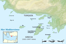
Strongili Megistis[1][2] (en griego: Στρογγυλή Μεγίστης) Strongyli o Ypsili es un islote perteneciente a Grecia,[3][4] se encuentra localizado en el Mediterráneo oriental,[5] a unos cuatro kilómetros al sureste de la isla de Kastelórizo. La isla tiene unos 1.5 kilómetros de largo y hasta 700 metros de ancho. Cubre un área de unos 0.9 kilómetros cuadrados. Es bastante plana y está cubierta de macchia. El islote no tiene residentes permanentes.
Strongyli es el territorio griego extremo oriental. Administrativamente es parte del municipio de Megisti. Según el censo de 2011 la isla está desierta. Dispone de un faro, cuya característica es la de ser el edificio más oriental de Grecia. También hay un teleférico de carga que es usado por el ejército griego para transportar carga desde el área de desembarco hasta el puesto de vigilancia de Stroghyli.
El islote es conocido en turco: Çam Adası («isla de los pinos»).
Véase también
Referencias
- ↑ Wittke, A. A.; Mechanics, International Society for Rock (1982). Rock mechanics: caverns and pressure shafts (en inglés). A.A. Balkema. ISBN 978-90-6191-232-3. Consultado el 11 de septiembre de 2020.
- ↑ Department, Great Britain Hydrographic (1987). Mediterranean Pilot: Aegean Sea and approaches with adjacent coasts of Greece and Turkey (en inglés). Hydrographer of the Navy. Consultado el 11 de septiembre de 2020.
- ↑ Wire, Elinor De; Reyes-Pergioudakis, Dolores (2010). The Lighthouses of Greece (en inglés). Pineapple Press Inc. ISBN 978-1-56164-452-0. Consultado el 11 de septiembre de 2020.
- ↑ Baumgarten, Monika I. (1987). Baedeker's Greek Islands (en inglés). Prentice Hall Press. ISBN 978-0-13-058132-7. Consultado el 11 de septiembre de 2020.
- ↑ The Mediterranean Pilot (en inglés). Hydrographic Office, Admiralty. 1918. Consultado el 11 de septiembre de 2020.
Enlaces externos
 Datos: Q1501628
 Multimedia: Strongyli Megistis / Q1501628