
No se dispone de una resolución más alta.
SafsafOasis_SAR_comparison.jpg (540 × 588 píxeles; tamaño de archivo: 154 kB; tipo MIME: image/jpeg)
Resumen
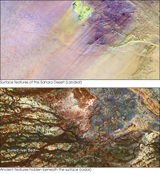
| Descripción | Two images of the Safsaf Oasis in The Sahara. The top image (taken by the Landat Thematic Mapper) is the surface. The bottom (taken by the Spaceborne Imaging Radar-C/X-band Synthetic Aperture Radar (SIR-C/X-SAR) on board the Space Shuttle Endeavour on April 16, 1994) is the rock layer underneath, revealing black channels cut by the meandering of an ancient river. |
| Fecha | not specified |
| Fuente | http://earthobservatory.nasa.gov/Newsroom/NewImages/images.php3?img_id=16963 |
| Autor | NASA/JPL Imaging Radar team. |
| Permiso (Reutilización de este archivo) |
Public domain |
| Otras versiones |
|


Licencia
| Este archivo es de dominio público porque fue creado por la NASA. Las políticas sobre copyright de la NASA estipulan que «el material de la NASA no está protegido con copyright a menos que se indique lo contrario». (Políticas sobre copyright de la NASA o Políticas sobre la utilización de imágenes del Jet Propulsion Laboratory). | ||
 |
Advertencias:
|
Historial del archivo
Haz clic sobre una fecha y hora para ver el archivo tal como apareció en ese momento.
| Fecha y hora | Miniatura | Dimensiones | Usuario | Comentario | |
|---|---|---|---|---|---|
| actual | 15:55 9 may 2006 | | 540 × 588 (154 kB) | Holly Cheng | {{Information | Description=Two images of the Safsaf Oasis in the Sahara. The top image (taken by the Landat Thematic Mapper) is the surface. The bottom (taken by the Spaceborne Imaging Radar-C/X-band Synthetic Aperture Radar (SIR-C/X-SAR) on board the Sp |
Usos del archivo
Las siguientes páginas usan este archivo:
Uso global del archivo
Las wikis siguientes utilizan este archivo:
- Uso en eu.wikipedia.org
- Uso en la.wikipedia.org
- Uso en nds-nl.wikipedia.org
- Uso en rw.wikipedia.org
- Uso en sw.wikipedia.org
- Uso en vi.wikipedia.org
- Uso en zh-yue.wikipedia.org