
Tamaño de esta previsualización: 548 × 600 píxeles. Otras resoluciones: 219 × 240 píxeles · 438 × 480 píxeles · 701 × 768 píxeles · 935 × 1024 píxeles · 1845 × 2020 píxeles.
Ver la imagen en su resolución original (1845 × 2020 píxeles; tamaño de archivo: 335 kB; tipo MIME: image/jpeg)
Resumen
| Descripción |
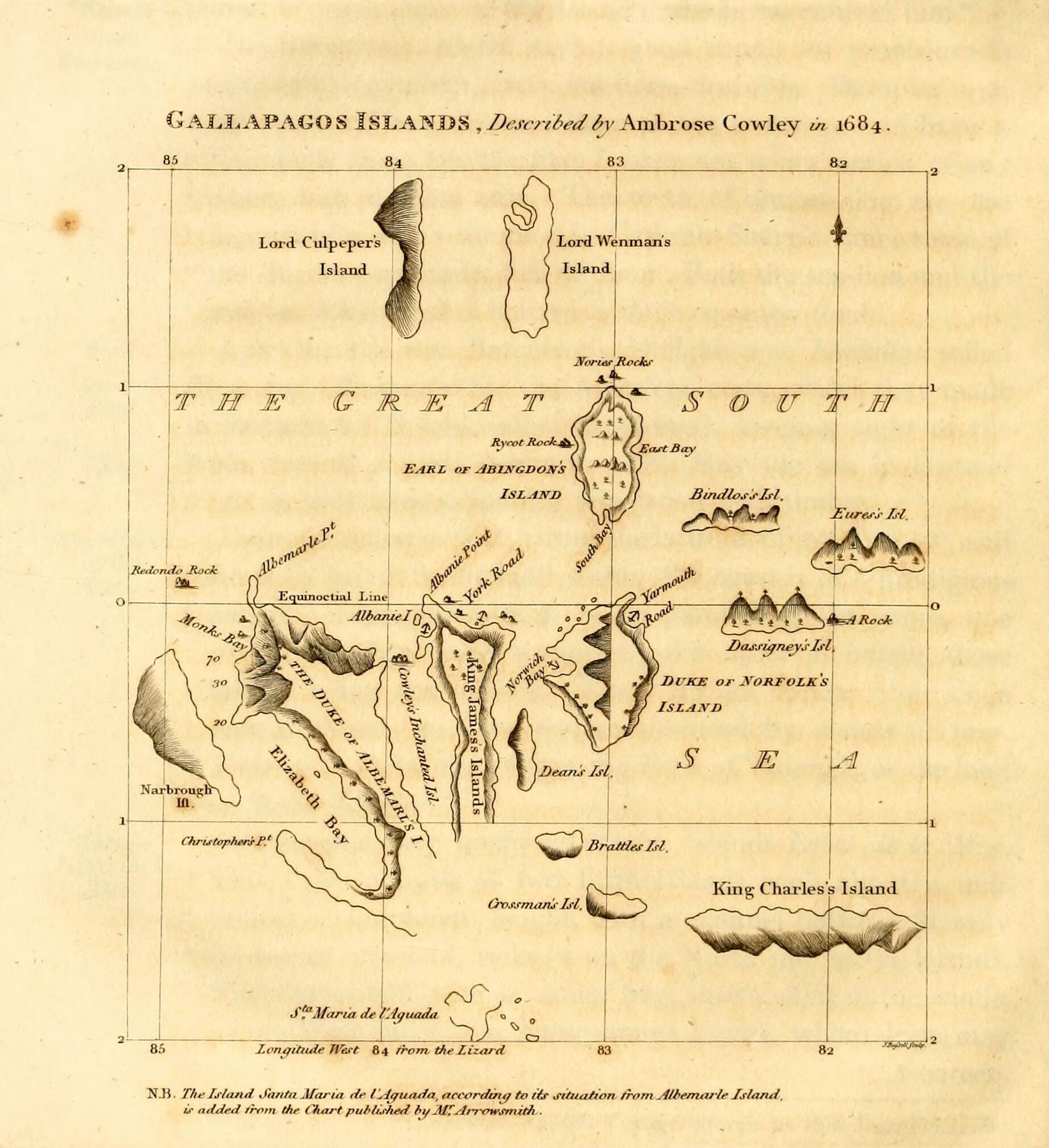
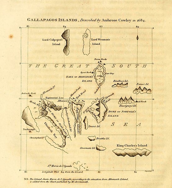
English: Galapagos Islands, described by Ambrose Cowley in 1684.
|
| Fecha | 1816, revision of a 1684 map |
| Fuente | James Burney's A Chronological History of the Discoveries in the South Sea or Pacific Ocean, Vol. IV, p. 145. |
| Autor | John Russell, based on an map by William Ambrosia Cowley with influence from Emanuel Bowen and William Arrowsmith's separate revisions |
Licencia
Este archivo está en el dominio público en los Estados Unidos. Esto se aplica a los trabajos de Estados Unidos donde los derechos de autor han expirado, a menudo porque su primera publicación ocurrió antes del 1 de enero de 1929. Véase esta página para explicación adicional.
|
 | |
 |
Esta imagen puede estar protegida fuera de los Estados Unidos —especialmente en Canadá, China (excepto Hong-Kong, Macao, o el área de Taiwán), Alemania o Suiza—. El creador y el año de publicación son información esencial y deben ser proporcionados. Véase Wikipedia:Derechos de autor para más detalles.
|
| Annotations | This image is annotated: View the annotations at Commons |
Historial del archivo
Haz clic sobre una fecha y hora para ver el archivo tal como apareció en ese momento.
| Fecha y hora | Miniatura | Dimensiones | Usuario | Comentario | |
|---|---|---|---|---|---|
| actual | 21:17 11 may 2023 | | 1845 × 2020 (335 kB) | <bdi>LlywelynII</bdi> | Cropped using CropTool to the size of the actual map pasted onto the book page. |
| 21:13 11 may 2023 |  | 2148 × 2892 (437 kB) | <bdi>LlywelynII</bdi> | Much higher quality version from archive.org copy of the work | |
| 20:10 11 may 2023 |  | 672 × 845 (413 kB) | <bdi>LlywelynII</bdi> | Reverted to version as of 18:11, 11 November 2010 (UTC) These are completely different maps from different sources and the original shouldn't've been replaced. | |
| 19:12 25 sep 2012 |  | 2357 × 3831 (10,46 MB) | <bdi>Jojagal</bdi> | Mapa de las Islas Galápagos según el Capitán Cowley (1684) - AHG | |
| 18:11 11 nov 2010 |  | 672 × 845 (413 kB) | <bdi>Alcmaeonid</bdi> | {{Information |Description={{en|1=Map of the Galapagos Islands as described by Ambrose Cowlev in 1684.}} |Source=A chronological history of the discoveries in the South Sea or Pacific Ocean ; illustrated with charts volume 4 |Author=James Burney |Date=180 |
Usos del archivo
Las siguientes páginas usan este archivo:
Uso global del archivo
Las wikis siguientes utilizan este archivo:
- Uso en ast.wikipedia.org
- Uso en de.wikipedia.org
- Uso en en.wikipedia.org
- Uso en fi.wikipedia.org
- Uso en fr.wikipedia.org
- Uso en ko.wikipedia.org
- Uso en mk.wikipedia.org
- Uso en pl.wikipedia.org
- Uso en stq.wikipedia.org
- Uso en zh.wikipedia.org