

Tamaño de esta previsualización PNG del archivo SVG: 783 × 600 píxeles. Otras resoluciones: 313 × 240 píxeles · 627 × 480 píxeles · 1003 × 768 píxeles · 1280 × 980 píxeles · 2560 × 1961 píxeles · 2538 × 1944 píxeles.
Ver la imagen en su resolución original ((Imagen SVG, nominalmente 2538 × 1944 pixels, tamaño de archivo: 1,33 MB))
| Descripción |
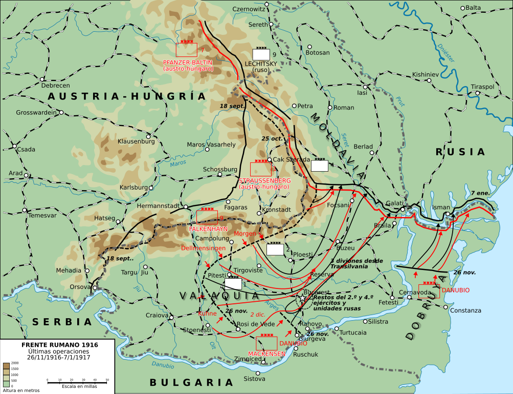
Últimas operaciones de la campaña rumana de 1916: la retirada a Moldavia y la toma por los Imperios Centrales de Dobruja y Valaquia. |
||
| Fecha | (UTC) | ||
| Fuente | |||
| Autor |
|

| Esta es una imagen retocada, lo que significa que ha sido alterada digitalmente de su versión original. Modificaciones: turned into svg and Spanish. La original se puede ver aquí: Romania-WW1-3.jpg. Las modificaciones las hizo Rowanwindwhistler.
|
Este archivo se encuentra bajo la licencia Creative Commons Genérica de Atribución/Compartir-Igual 3.0.
- Eres libre:
- de compartir – de copiar, distribuir y transmitir el trabajo
- de remezclar – de adaptar el trabajo
- Bajo las siguientes condiciones:
- atribución – Debes otorgar el crédito correspondiente, proporcionar un enlace a la licencia e indicar si realizaste algún cambio. Puedes hacerlo de cualquier manera razonable pero no de manera que sugiera que el licenciante te respalda a ti o al uso que hagas del trabajo.
- compartir igual – En caso de mezclar, transformar o modificar este trabajo, deberás distribuir el trabajo resultante bajo la misma licencia o una compatible como el original.
Registro original de carga
This image is a derivative work of the following images:
- File:Romania-WW1-3.jpg licensed with PD-USGov
- 2006-12-28T16:42:16Z Electionworld 1018x868 (162492 Bytes) {{ew|en|Cglassey}} == Summary == This map shows the conquest of Romania: November 1916 through till January of 1917 This map was created by the Department of Military Art and Engineering, at the U.S. Military Academy (West P
Uploaded with derivativeFX
Historial del archivo
Haz clic sobre una fecha y hora para ver el archivo tal como apareció en ese momento.
| Fecha y hora | Miniatura | Dimensiones | Usuario | Comentario | |
|---|---|---|---|---|---|
| actual | 22:01 7 oct 2017 | | 2538 × 1944 (1,33 MB) | Rowanwindwhistler | Size |
| 21:51 7 oct 2017 |  | 2553 × 2000 (1,29 MB) | Rowanwindwhistler | Region names, river names, Jiu river, legend... | |
| 09:03 22 ene 2017 |  | 1284 × 983 (1,05 MB) | Rowanwindwhistler | Some minor errors corrected. Fake text added. | |
| 06:12 4 feb 2016 |  | 1204 × 922 (474 kB) | Rowanwindwhistler | Some text moved for better readability | |
| 06:05 4 feb 2016 |  | 1204 × 922 (474 kB) | Rowanwindwhistler | Minor corrections, some colours & symbols from https://en.wikipedia.org/wiki/Wikipedia:WikiProject_Maps/Conventions | |
| 15:36 8 sep 2010 |  | 1242 × 961 (464 kB) | Rowanwindwhistler | Wrong unit deleted | |
| 15:33 8 sep 2010 |  | 1242 × 961 (472 kB) | Rowanwindwhistler | {{Information |Description={{en|1=This map shows the conquest of Romania: November 1916 through till January of 1917 This map was created by the Department of Military Art and Engineering, at the U.S. Military Academy (West Point). The initial version was |
Usos del archivo
Las siguientes páginas usan este archivo:
Uso global del archivo
Las wikis siguientes utilizan este archivo:
- Uso en ca.wikipedia.org
- Uso en fr.wikipedia.org
- Uso en sh.wikipedia.org
- Uso en uk.wikipedia.org