
| Zhob | |
|---|---|
 | |
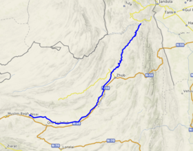 Course of the Zhob | |
| Location | |
| Country | Pakistan |
| province | Balochistan, Khyber Pakhtunkhwa |
| District | Zhob District |
| Physical characteristics | |
| Source | Near Tsari Mehtarazai |
| Mouth | Gomal River |
• location | Khajuri Kach |
| Length | 410 km (250 mi) |
Zhob River (Pashto: ږوب سيند; Urdu: دریائے ژوب) is located in Balochistan and Khyber Pakhtunkhwa, Pakistan. The total length of the Zhob River is 410 km, and it flows on a generally northeasterly course.
YouTube Encyclopedic
-
1/3Views:5178619 649
-
FORT SANDEMAN (Zhob 2016)
-
New Town School Zhob
-
ZHOB.2
Transcription
Etymology
In the Pashto language, Zhob means "oozing water".[1] Linguistically, the name is Irano-Aryan in origin and compares etymologically to those of the Little Zab and Great Zab rivers in the Tigris Basin.
Course
The Zhob River originates in the Kan Mehtarzai range (Tsari Mehtarzai Pass) near Muslim Bagh. It passes about 4 km west of the city of Zhob. As a tributary of the Gomal River, which it joins near Khajuri Kach,[1] the Zhob forms a part of the Indus River Basin.
Agriculture
The Zhob River is used to irrigate the land in northern Balochistan along with the Gomal River, making the fertile soil available for agriculture. Although in the 1960s and 1970s degradation of the channel of the Zhob decreased the irrigable acreage.[2]
Archaeology
Along the Zhob River there are located the ancient sites of Rana Ghundai, Periano Ghundai, Rehman Dheri, along with the nearby site of Gumla, which go before 3000 BC.
References
- ^ a b "Zhob District". Khyber Gateway. 1 April 2005. Archived from the original on 20 March 2012.
{{cite web}}: CS1 maint: unfit URL (link) - ^ Verheijen, Olaf (1998). Community Irrigation Systems in the Province of Balochistan (PDF). Lahore, Pakistan: International Irrigation Management Institute. p. 43. OCLC 152564336.
32°04′N 69°51′E / 32.067°N 69.850°E
This Balochistan location article is a stub. You can help Wikipedia by expanding it. |