
| Zeya | |
|---|---|
 Island on the Zeya. | |
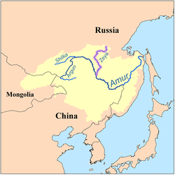 Map of the Amur drainage basin with the Zeya highlighted | |
| Native name | Зея (Russian) |
| Location | |
| Country | Russia |
| Federal subject | Amur Oblast |
| Physical characteristics | |
| Source | Toko-Stanovik |
| Mouth | Amur |
• coordinates | 50°14′31″N 127°35′53″E / 50.2419°N 127.598°E |
| Length | 1,242 km (772 mi)[1] |
| Basin size | 233,000 km2 (90,000 sq mi)[1] |
| Discharge | |
| • location | Blagoveshchensk[2][1] |
| • average | 1,810 m3/s (64,000 cu ft/s) |
| • minimum | 1.5 m3/s (53 cu ft/s) |
| • maximum | 14,200 m3/s (500,000 cu ft/s) |
| Basin features | |
| Progression | Amur→ Sea of Okhotsk |
The Zeya (Russian: Зе́я; from indigenous Evenki word "djee" (blade); Chinese: 结雅; Manchu: ᠵᡳᠩᡴᡳᡵᡳ
ᠪᡳᡵᠠ, Mölendroff: jingkiri bira) is a northern, left tributary of the Amur in Amur Oblast, Russia. It is 1,242 km (772 mi) long, and has a drainage basin of 233,000 km2 (90,000 sq mi).[3] The average flow of the river is 1,810 m3/s (64,000 cu ft/s).[1]
YouTube Encyclopedic
-
1/3Views:5331 4831 069
-
Вдоль рек Зея и Селемджа / Along the Zeya and Selemdzha Rivers -1912
-
Svobodny, Amur Oblast
-
Amur & Zeya 10 08 2013
Transcription
History
The first Russian documented to enter the area was Vassili Poyarkov.
Course
It rises in the Toko-Stanovik mountain ridge, a part of the Stanovoy Range.
The Zeya flows through the Zeya Reservoir, at the junction of the Tukuringra Range and Dzhagdy Range, and joins the Amur near Blagoveshchensk, at the border with China. Regulation of river discharge by Zeya Dam mitigates extremities of river flow down to 5000 m³/s. The Zeya contributes around 16% of both the average and maximum flow of de Amur because of the flow regulations. In the past, the Zeya could have contributed up to almost 50% of the Amur's maximum flow of approximately 30,000 m³/s.
The main tributaries of the Zeya are Tok, Mulmuga, Bryanta, Gilyuy, and Urkan on the right, and Kupuri, Argi, Dep, Selemdzha, and Tom on the left.[4]
The river freezes from November to May. When it is unfrozen, the river is navigable with the most important river ports being Zeya, Svobodny, and Blagoveshchensk.
See also
References
- ^ a b c d "Amur-Heilong River Basin Reader" (PDF). ISBN 9789881722713.
- ^ Sokolov, Far East // Hydrography of USSR. (in Russian)
- ^ "Река ЗЕЯ in the State Water Register of Russia". textual.ru (in Russian).
- ^ Зея (река в Амурской обл.), Great Soviet Encyclopedia
External links
 Media related to Zeya River at Wikimedia Commons
This article related to a river in Russia is a stub. You can help Wikipedia by expanding it. |