
 Yapen with Serui seen in the background. | |
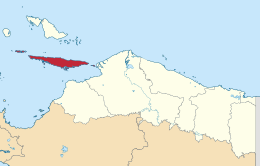 Location of Yapen Islands | |
| Geography | |
|---|---|
| Location | Melanesia; Oceania |
| Coordinates | 1°45′S 136°08′E / 1.750°S 136.133°E |
| Area | 2,278 km2 (880 sq mi) |
| Highest elevation | 1,496 m (4908 ft) |
| Administration | |
Indonesia | |
| Province | Papua |
| Regency | Yapen Islands |
| Additional information | |
| Time zone | |


Yapen (also Japan, Jobi)[1] is an island of Papua, Indonesia. The Yapen Strait separates Yapen and the Biak Islands to the north. It is in Cenderawasih Bay off the north-western coast of the island of New Guinea. To the west is Mios Num Island across the Mios Num Strait, and to the east Kurudu Island. Off the southeast coast of Yapen are the Amboi Islands and to the southwest are the Kuran Islands.[2] Together these islands form the Yapen Islands Regency within the province of Papua. It is populated with communities of Yobi, Randowaya, Serui, and Ansus. Its highest point is 1,496 metres (4,908 feet).
First recorded sighting by Europeans is by Spanish navigator Álvaro de Saavedra who landed on 24 June 1528 when trying to return from Tidore to New Spain. It was then charted as Paine within the Islas de Oro (Golden Islands in Spanish), as they called Yapen and the present day Schoutens. In 1545 it was visited by Íñigo Órtiz de Retes on board of galleon San Juan.[3]
The earthquake of 1979 caused serious damage and killed at least 115 people on the island.[4]
YouTube Encyclopedic
-
1/2Views:6 289663
-
KELILING KOTA SERUI 2021 | Kepulauan Yapen | Papua
-
Kampung Ansus Distrik Yapen Barat Kab. Kepulauan Yapen
Transcription
Ecology
The island has been designated the Yapen rain forests ecoregion by the World Wildlife Federation for its unique bird life and flora. Two protected areas cover a third of the island, whose population is growing with subsequent clearance of forest for planting and firewood.[5]
See also
References
- ^ "History of expeditions in Papua Indonesia". The Papua Insects Foundation. Retrieved 2008-04-26.
- ^ Trimahanani, Emy (2020-12-07). "Pantai Tindaret, Pantai Indah di Balik Tebing dan Gunung". Berita Daerah. Retrieved 2021-03-17.
- ^ Coello, Francisco "Conflicto hispano-alemán" Boletín de Sociedad Geográfica de Madrid, t.XIX. 2º semestre 1886 , Madrid, p.234,239,309,310,315,319
- ^ National Geophysical Data Center / World Data Service (NGDC/WDS): NCEI/WDS Global Significant Earthquake Database. NOAA National Centers for Environmental Information (1972). "Significant Earthquake Information" (Data Set). NOAA National Centers for Environmental Information. doi:10.7289/V5TD9V7K. Retrieved 10 June 2022.
- ^ "Southeastern Asia: Island of Yapen in Indonesia | Ecoregions | WWF".
This Papua location article is a stub. You can help Wikipedia by expanding it. |