
Woodhull | |
|---|---|
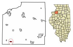 Location of Woodhull in Henry County, Illinois. | |
 Location of Illinois in the United States | |
| Coordinates: 41°10′43″N 90°19′19″W / 41.17861°N 90.32194°W | |
| Country | United States |
| State | Illinois |
| County | Henry |
| Incorporated | 1870[1] |
| Area | |
| • Total | 0.88 sq mi (2.29 km2) |
| • Land | 0.88 sq mi (2.29 km2) |
| • Water | 0.00 sq mi (0.00 km2) |
| Elevation | 810 ft (250 m) |
| Population (2020) | |
| • Total | 754 |
| • Density | 854.88/sq mi (329.95/km2) |
| Time zone | UTC-6 (CST) |
| • Summer (DST) | UTC-5 (CDT) |
| ZIP Code(s) | 61490 |
| Area code | 309 |
| FIPS code | 17-83063 |
| Website | www |
| [3] | |
Woodhull is a village in Henry County, Illinois. As of the 2010 census, the village had a population of 811, up from 809 in 2000.
YouTube Encyclopedic
-
1/2Views:5 4726 035
-
BigRigTravels LIVE! Woodhull, Illinois to Dayton, Ohio Interstate 74 & 70 East-Dec. 2, 2017
-
BigRigTravels LIVE! Brooklyn, Iowa to Woodhull, Illinois Interstates 80 & 74-Dec. 1, 2017
Transcription
History
The town was laid out by Maxwell Woodhull on September 30, 1857. An addition was laid out in 1867, and another in 1870. That same year, the town was incorporated. In 1994, the High School girls' basketball team almost made history in the I.H.S.A. Basketball state championship but came up short.[1]
Geography
Woodhull is located at 41°10′43″N 90°19′19″W / 41.17861°N 90.32194°W (41.1785893, -90.3219500).[3]
According to the 2010 census, Woodhull has a total area of 0.82 square miles (2.12 km2), all land.[4]
Demographics
| Census | Pop. | Note | %± |
|---|---|---|---|
| 1880 | 650 | — | |
| 1890 | 608 | −6.5% | |
| 1900 | 774 | 27.3% | |
| 1910 | 692 | −10.6% | |
| 1920 | 700 | 1.2% | |
| 1930 | 567 | −19.0% | |
| 1940 | 638 | 12.5% | |
| 1950 | 718 | 12.5% | |
| 1960 | 779 | 8.5% | |
| 1970 | 905 | 16.2% | |
| 1980 | 901 | −0.4% | |
| 1990 | 808 | −10.3% | |
| 2000 | 809 | 0.1% | |
| 2010 | 811 | 0.2% | |
| 2020 | 754 | −7.0% | |
| U.S. Decennial Census[5] | |||
As of the census[6] of 2000, there were 809 people, 348 households, and 238 families living in the village. The population density was 980.6 inhabitants per square mile (378.6/km2). There were 361 housing units at an average density of 437.6 sq mi (1,133 km2). The racial makeup of the village was 99% White, 0.4% African American, 0.1% Native American, 0.1% Asian, and 0.4% from two or more races. Hispanic or Latino of any race were 1.2% of the population.
There were 348 households, out of which 28.2% had children under the age of 18 living with them, 57.5% were married couples living together, 7.8% had a female householder with no husband present, and 31.6% were non-families. 29.6% of all households were made up of individuals, and 15.8% had someone living alone who was 65 years of age or older. The average household size was 2.32 and the average family size was 2.86.
In the village, the population was spread out, with 23.9% under the age of 18, 6.4% from 18 to 24, 28.1% from 25 to 44, 23.5% from 45 to 64, and 18.2% who were 65 years of age or older. The median age was 40 years. For every 100 females, there were 94.5 males. For every 100 females age 18 and over, there were 92.5 males.
The median income for a household in the village was $35,288, and the median income for a family was $42,500. Males had a median income of $30,000 versus $26,136 for females. The per capita income for the village was $18,738. About 5.4% of families and 9.1% of the population were below the poverty line, including 10.7% of those under age 18 and 12.3% of those age 65 or over.
Education
AlWood Middle-High School[7] is located in Woodhull, with students coming from nearby Alpha after the merger in the early 1950s. Students also attend from the country surrounding Ophiem, Lynn Center, Andover, Cambridge, New Windsor, Rio, and Oneida. The school's mascot is the Aces, although it has been referred to as the "Flying Aces" numerous times.
Notable people
- Don Samuelson, 25th Governor of Idaho from 1967 to 1971; born in Woodhull.[8]
- Daniel Swanson, Illinois state representative; born in Woodhull.[9]
References
- ^ a b The History of Henry County, Illinois, Its Tax-Payers and Voters. Chicago: H. F. Kett and Company. 1877. pp. 537–539.
- ^ "2020 U.S. Gazetteer Files". United States Census Bureau. Retrieved March 15, 2022.
- ^ a b U.S. Geological Survey Geographic Names Information System: Village of Woodhull
- ^ "G001 - Geographic Identifiers - 2010 Census Summary File 1". United States Census Bureau. Archived from the original on February 13, 2020. Retrieved December 25, 2015.
- ^ "Census of Population and Housing". Census.gov. Retrieved June 4, 2015.
- ^ "U.S. Census website". United States Census Bureau. Retrieved January 31, 2008.
- ^ AlWood Community District #225
- ^ "Idaho Governor Don William Samuelson". National Governors Association. Retrieved September 25, 2012.
- ^ Illinois General Assembly-Daniel Swanson
External links
- City-Data.com Comprehensive Statistical Data and more about Woodhull
- ePodunk: Profile for Woodhull, Illinois, IL
Municipalities and communities of Henry County, Illinois, United States | ||
|---|---|---|
| Cities |  | |
| Towns | ||
| Villages | ||
| Townships | ||
| CDPs | ||
| Other communities | ||
| Footnotes | ‡This populated place also has portions in an adjacent county or counties | |
| International | |
|---|---|
| National | |