
Woltersdorf | |
|---|---|
 Coat of arms | |
Location of Woltersdorf within Lüchow-Dannenberg district 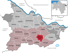 | |
 Woltersdorf  Woltersdorf | |
| Coordinates: 52°57′N 11°13′E / 52.950°N 11.217°E | |
| Country | Germany |
| State | Lower Saxony |
| District | Lüchow-Dannenberg |
| Municipal assoc. | Lüchow (Wendland) |
| Subdivisions | 4 Ortsteile |
| Government | |
| • Mayor | Claudia Hennings (CDU) |
| Area | |
| • Total | 27.97 km2 (10.80 sq mi) |
| Elevation | 31 m (102 ft) |
| Population (2021-12-31)[1] | |
| • Total | 884 |
| • Density | 32/km2 (82/sq mi) |
| Time zone | UTC+01:00 (CET) |
| • Summer (DST) | UTC+02:00 (CEST) |
| Postal codes | 29497 |
| Dialling codes | 05841 |
| Vehicle registration | DAN |
Woltersdorf is a municipality in the district Lüchow-Dannenberg, in Lower Saxony, Germany.
The municipality Woltersdorf includes the villages Woltersdorf, Klein Breese, Lichtenberg and Thurau.
Famous sites around Woltersdorf are the Brautstein ("stone of the bride") and the Feldkirche ("church on the field"). Both of these can be seen in the coat of arms of Woltersdorf.
The Brautstein is a formation of ancient boulders left behind by glaciers in the ice age. The Feldkirchr has a little stone in its walls which was taken from the Slavic population and was built into the church.
References
Towns and municipalities in Lüchow-Dannenberg (district) | ||
|---|---|---|
 | ||
| Unincorporated areas |
| |
| International | |
|---|---|
| National | |
This Lüchow-Dannenberg location article is a stub. You can help Wikipedia by expanding it. |