

Vukovar Plateau (Croatian: Vukovarski ravnjak, Serbian: Вуковарски равњак / Vukovarski ravnjak) is a low loess plateau in eastern Croatia in the region of Syrmia named after the town of Vukovar. The eponymous town of Vukovar originally developed on the tall Danubian riverbank slopes of the plateau.[1] The plateau represent western Syrmian drainage divide between the Danube and Sava rivers leading up to Fruška Gora hills further east.[2][3] Drainage divide formed by the plateau nevertheless does not form impenetrable hydraulic barrier but rather area of differentiated levels of water transmissivity.[4]
Together with Spačva basin and Sava basin it is one of the primary microregions of the Vukovar-Srijem County.[5] Numerous prehistoric areological sites were discovered on the plateau which represented optimal condition for human settlement and important communication route.[6] Southwest edge of the plateau reaches the village of Mirkovci, suburb of Vinkovci, while eastern edges of the plateau reach Šarengrad, Bapska and the town of Šid in neighbouring Serbia.[2][7] The region is home to one of the last remaining steppe grasslands in Croatia near the village of Opatovac.[8]
Gallery
-
 loess plateau Vukovar
 -

-

-
 Opatovac
See also
References
- ^ n.a. (n.d.). "Vukovar" (in Serbian). Serb National Council. Retrieved 8 June 2023.
- ^ a b n.a. (n.d.). "ŽUPANIJA VUKOVARSKO-SRIJEMSKA PROSTORNI PLAN UREĐENJA GRADA ILOKA" (PDF) (in Croatian). Faculty of Architecture, University of Zagreb. Retrieved 8 June 2023.
- ^ Nenad Pokos (n.d.). "Pregled bibliografske jedinice broj: 590710 Geografska obilježja Vukovarsko-srijemske županije" (in Croatian). CROSBI. Retrieved 8 June 2023.
- ^ A. Bačani; M. Šparica; J. Velić (1999). "Quaternary Deposits as the Hydrogeological System of Eastern Slavonia". Geologia Croatica. 52 (2): 141–152.
- ^ n.a. (n.d.). "Vukovarsko-srijemska županija" (in Croatian). Miroslav Krleža Institute of Lexicography. Retrieved 8 June 2023.
- ^ Marko Dizdar; Daria Ložnjak Dizdar (2009). "Terenski pregledi područja općina Ilok, Lovas i Tovarnik u 2008. g." Annales Instituti Archaeologici. V (1): 117–121.
- ^ Stefan Babić; Miloš Macura; Stefan Maćešić; Marko Rogan; Luka Šimić; Nemanja Trifunović (n.d.). "Рељеф" (in Serbian). Elementary School Mirkovci. Retrieved 8 June 2023.
- ^ n.a. (n.d.). "Stepska staništa kod Opatovca". Natura 2000. Retrieved 8 June 2023.
| Principal historical regions |  | ||||||||
|---|---|---|---|---|---|---|---|---|---|
| Smaller regions |
| ||||||||
| History |
|  |
|---|---|---|
| Districts |
| |
| Buildings and landmarks | ||
| Places of worship |
| |
| Culture |
| |
| Education | ||
| Transport | ||
| Manifestations |
| |
| Neighboring municipalities | ||
Bogdanovci Municipality | ||
|---|---|---|
| Settlements |
|  |
| Attractions | ||
| Traffic routes | ||
| History | ||
| Neighboring towns and municipalities | ||
Negoslavci Municipality | ||
|---|---|---|
| Settlements |
|  |
| Attractions | ||
| Traffic routes | ||
| History | ||
| Neighboring towns and municipalities | ||
Nijemci municipality | ||
|---|---|---|
| Settlements | 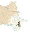 | |
| Attractions | ||
| History | ||
| Traffic routes | ||
| Notable natives and residents |
| |
| Neighboring towns and municipalities | ||
Stari Jankovci Municipality | ||
|---|---|---|
| Settlements |  | |
| Attractions | ||
| Traffic routes | ||
| Neighboring towns and municipalities | ||
Šid Municipality | ||
|---|---|---|
| Settlements |   | |
| History | ||
| Buildings and landmarks | ||
| Places of worship |
| |
| Transport | ||
| Sport | ||
Tompojevci Municipality | ||
|---|---|---|
| Settlements |
|  |
| Attractions | ||
| History | ||
| Neighboring towns and municipalities | ||
| Settlements |  | |
|---|---|---|
| Historical settlements | ||
| Attractions | ||
| Traffic routes | ||
| History | ||
| Notable natives and residents |
| |
| Neighboring towns and municipalities | ||
45°16′N 19°02′E / 45.26°N 19.03°E