
| Vindhya Pradesh | |||||||||
|---|---|---|---|---|---|---|---|---|---|
| State of India | |||||||||
| 1948–1956 | |||||||||
Coat of arms
| |||||||||
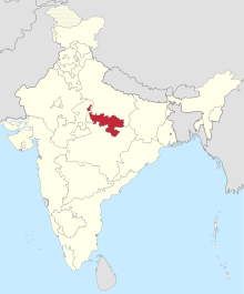 1951 map of India. Vindhya Pradesh is shown in the centre. | |||||||||
| Capital | Rewa | ||||||||
| Area | |||||||||
• | 61,131.5 km2 (23,603.0 sq mi) | ||||||||
| Population | |||||||||
• | 3,600,000 | ||||||||
| History | |||||||||
• Creation of Vindhya Pradesh State | 1948 | ||||||||
| 1956 | |||||||||
| |||||||||
| Pranab Kumar Bhattacharyya (1977). Historical Geography of Madhya Pradesh from Early Records. Delhi: Motilal Banarsidass. pp. 54–5. | |||||||||
Vindhya Pradesh was a former state of India. It occupied an area of 61,131.5 km2 (23,603 sq. miles).[1] It was created in 1948 as Union of Baghelkhand and Bundelkhand States, shortly after Indian independence, from the territories of the princely states in the eastern portion of the former Central India Agency. It was named as Vindhya Pradesh on 25 January 1950 after the Vindhya Range, which runs through the centre of the province. The capital of the state was the former princely state of Rewa. It lays between Uttar Pradesh to the north and Madhya Pradesh to the south, and the enclave of Datia, which lay a short distance to the west, was surrounded by the state of Madhya Bharat.
Vindhya Pradesh was merged into Madhya Pradesh in 1956, following the States Reorganisation Act.[2]
YouTube Encyclopedic
-
1/4Views:49 39757 75816 38318 169
-
Vindhya Range। UPSC PYQ | Map In Shorts | StudyIQ IAS Hindi। Amrit Upadhyay I UPSC 2023
-
Vindhya Range। UPSC PYQ | Map In Shorts | StudyIQ IAS Hindi #upsc #ias #cse #ips
-
Madhya Pradesh Public Service Commission |VINDHYAN RANGE | MPPSC
-
विंध्य प्रदेश के उदय से विलय तक की पूरी कहानी । #vindhya pradesh history in hindi
Transcription
History
Vindhya Pradesh state was formed on 12 March 1948 and the newly formed state was inaugurated on 4 April 1948. Following its formation 36 princely states were merged to form Vindhya Pradesh state:
- Singrauli
- Rewa
- Panna
- Datia
- Orchha
- Ajaigarh
- Baoni
- Baraundha
- Bijawar
- Chhatarpur
- Charkhari
- Maihar
- Nagod
- Samthar
- Alipura
- Tiroha
- Banka-Pahari
- Beri
- Bhaisunda (Chaube Jagir)
- Bihat
- Bijna
- Dhurwai
- Garrauli
- Gaurihar
- Jaso
- Jigni
- Khaniadhana
- Kamta Rajaula (Chaube Jagir)
- Kothi
- Kirur (Kubje Jagir)
- Lugasi
- Naigawan Rebai
- Pahra (Chaube Jagir)
- Paldeo (Chaube Jagir)
- Sarila
- Sohawal
- Tori-Fatehpur (Hasht-Bhaiya Jagir)
On 25 January 1950, 11 erstwhile princely states, namely, Bihat, Banka Paharee, Baoni, Beri, Bijna, Charkhari, Jigni, Samthar, Sarila, Tori-Fatehpur and parts of Kirur Kubje were transferred to Uttar Pradesh and Madhya Bharat. Vindhya Pradesh, together with the states of Madhya Bharat and Bhopal State, was merged into Madhya Pradesh on 1 November 1956.
Divisions

After formation, the state was divided into two divisions, which were further divided into 8 districts.
Bundelkhand Division with its headquarters at Nowgaon comprised the following 4 districts:
Baghelkhand Division with its headquarters at Singrauli and then Rewa comprised the following 4 districts:[1]
Politics
The nominal heads of the state were the Rajpramukh from 1948–49, the Chief Commissioner from March 1949–1952 and the Lieutenant Governor from March 1952–October 1956. The state had a Vidhan Sabha comprising 60 members elected from 48 constituencies (36 single-member and 12 double-member).[3] There were 4 Lok Sabha constituencies in the state (2 single-member and 2 double-member).[4]
Following the formation of the state, Martand Singh, the last ruler of the princely state of Rewa became the Rajpramukh and Yadvendra Singh, the last ruler of the princely state of Panna became the Uparajpramukh. Initially Awadhesh Pratap Singh became the Chief Minister of the Vindhya Pradesh.
After he resigned on 14 April 1949, N.B. Bonerji, took over on 15 April 1949 as Chief Commissioner. He was succeeded by S. N. Mehta.
In the first general election in 1951, the Indian National Congress won 40 seats and the Socialist Party won 11 seats.[3] S.N.Shukla of Indian National Congress became the Chief Minister of the state on 13 March 1952, Shivanand became the Speaker and Ram Kishore Shukla of Socialist Party the leader of the opposition of the house. The house dissolved on 31 October 1956.
Nowadays the voices of separation of Vindhya Pradesh from Madhya Pradesh, are stoked by Maihar MLA Narayan Tripathi and social worker, Kuldeep Agnihotri, who is associated with the Agni Shakti Education Foundation, in Rewa, Madhya Pradesh.[citation needed]
See also
References
- ^ a b Bhattacharyya, P. K. (1977). Historical Geography of Madhya Pradesh from Early Records. Delhi: Motilal Banarsidass. pp. 54–5. ISBN 0-8426-909-13.
- ^ "States Reorganisation Act, 1956". India Code Updated Acts. Ministry of Law and Justice, Government of India. 31 August 1956. pp. section 9. Retrieved 16 May 2013.
- ^ a b "Statistical Report on General Election, 1951 to the Legislative Assembly of Vindhya Pradesh" (PDF). Election Commission of India website.
- ^ "Statistical Report on General Elections, 1951 to the First Lok Sabha" (PDF). Election Commission of India website. Archived from the original (PDF) on 9 April 2009. Retrieved 29 October 2008.
| Part A States | ||
|---|---|---|
| Part B States | ||
| Part C States | ||
| Part D States | ||
| International | |
|---|---|
| National | |
24°32′N 81°18′E / 24.53°N 81.3°E