
Uebigau-Wahrenbrück | |
|---|---|
 Market square in Uebigau | |
 Coat of arms | |
Location of Uebigau-Wahrenbrück within Elbe-Elster district  | |
 Uebigau-Wahrenbrück  Uebigau-Wahrenbrück | |
| Coordinates: 51°33′N 13°21′E / 51.550°N 13.350°E | |
| Country | Germany |
| State | Brandenburg |
| District | Elbe-Elster |
| Municipal assoc. | Liebenwerda |
| Government | |
| • Mayor (2020–25) | Dittgard Hapich[1] |
| Area | |
| • Total | 134.91 km2 (52.09 sq mi) |
| Elevation | 84 m (276 ft) |
| Population (2022-12-31)[2] | |
| • Total | 5,159 |
| • Density | 38/km2 (99/sq mi) |
| Time zone | UTC+01:00 (CET) |
| • Summer (DST) | UTC+02:00 (CEST) |
| Postal codes | 04924, 04938 |
| Dialling codes | 035365 |
| Vehicle registration | EE, FI, LIB |
| Website | www.uebigau-wahrenbrueck.de |
Uebigau-Wahrenbrück is a town in the Elbe-Elster district, in southwestern Brandenburg, Germany. It is situated on the river Schwarze Elster, 11 km northwest of Bad Liebenwerda, and 21 km east of Torgau.
YouTube Encyclopedic
-
1/3Views:1 0901 035551
-
Neue Cross-Strecke in Uebigau
-
Grundschule Uebigau
-
Himmelsschaukel zu Uebigau
Transcription
Geography
The town is composed by the villages of Bahnsdorf, Beiersdorf, Beutersitz, Bomsdorf, Bönitz, Domsdorf, Drasdo, Kauxdorf, Langennaundorf, Marxdorf, München/Elster, Neudeck, Prestewitz, Rothstein, Saxdorf, Uebigau (municipal seat), Wahrenbrück, Wiederau, Wildgrube, Winkel and Zinsdorf.
History
From 1815 to 1944, the constituent localities of Uebigau-Wahrenbrück were part of the Prussian Province of Saxony. From 1944 to 1945, they were part of the Province of Halle-Merseburg. From 1952 to 1990, they were part of the Bezirk Cottbus of East Germany. On 31 December 2001, the town of Uebigau-Wahrenbrück was formed by merging the towns of Uebigau and Wahrenbrück with the municipalities of Bahnsdorf, Drasdo and Wiederau.
Demography
-
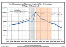 Development of Population since 1875 within the Current Boundaries (Blue Line: Population; Dotted Line: Comparison to Population Development of Brandenburg state; Grey Background: Time of Nazi rule; Red Background: Time of Communist rule)
 -
 Recent Population Development and Projections (Population Development before Census 2011 (blue line); Recent Population Development according to the Census in Germany in 2011 (blue bordered line); Official projections for 2005-2030 (yellow line); for 2017-2030 (scarlet line)


|
|
|
See also
- Marxdorfer Wolfshund

Notable people
- Johann Gottlieb Graun (1702–1771), a German Baroque/Classical era composer and violinist
- Carl Heinrich Graun (1704–1759), a German composer and tenor.[4]
- Gustav Seyffarth (1796–1885), a German-American Egyptologist
References
- ^ Landkreis Elbe-Elster Wahl der Bürgermeisterin / des Bürgermeisters, accessed 1 July 2021.
- ^ "Bevölkerungsentwicklung und Bevölkerungsstandim Land Brandenburg Dezember 2022" (PDF). Amt für Statistik Berlin-Brandenburg (in German). June 2023.
- ^ Detailed data sources are to be found in the Wikimedia Commons.Population Projection Brandenburg at Wikimedia Commons
- ^ . Encyclopædia Britannica. Vol. XI (9th ed.). 1880. p. 64-65.
External links
![]() Media related to Uebigau-Wahrenbrück at Wikimedia Commons
Media related to Uebigau-Wahrenbrück at Wikimedia Commons
Towns and municipalities in Elbe-Elster | ||
|---|---|---|
|  | |
| International | |
|---|---|
| National | |
| Geographic | |
This Brandenburg location article is a stub. You can help Wikipedia by expanding it. |