
Tramin | |
|---|---|
| Gemeinde Tramin an der Weinstraße Comune di Termeno sulla Strada del Vino | |
 Market place | |
 Coat of arms | |
Location of Tramin  | |
 Tramin Location of Tramin in Italy  Tramin Tramin (Trentino-Alto Adige/Südtirol) | |
| Coordinates: 46°21′N 11°15′E / 46.350°N 11.250°E | |
| Country | Italy |
| Region | Trentino-Alto Adige/Südtirol |
| Province | South Tyrol (BZ) |
| Frazioni | Rungg (Ronchi), Söll (Sella) |
| Government | |
| • Mayor | Wolfgang Oberhofer |
| Area | |
| • Total | 19.4 km2 (7.5 sq mi) |
| Elevation | 276 m (906 ft) |
| Population (Nov. 2010)[2] | |
| • Total | 3,296 |
| • Density | 170/km2 (440/sq mi) |
| Demonym(s) | German: Traminer Italian: di Termeno |
| Time zone | UTC+1 (CET) |
| • Summer (DST) | UTC+2 (CEST) |
| Postal code | 39040 |
| Dialing code | 0471 |
| Website | Official website |
Tramin an der Weinstraße (German pronunciation: [traˈmiːn an deːɐ̯ ˈvaɪnˌʃtraːsə]; Italian: Termeno sulla Strada del Vino [terˈmɛːno sulla ˈstraːda del ˈviːno]), often abbreviated to Tramin or Termeno, is a comune (municipality) in South Tyrol, northern Italy, located about 20 kilometres (12 miles) southwest of the city of Bolzano. The name of the grape variety Gewürztraminer has its origins in Tramin.
Geography
As of November 30, 2010, Tramin had a population of 3,296 and an area of 19.4 square kilometres (7.5 sq mi).[3]
The municipality contains the frazioni (subdivisions, mainly villages and hamlets) Rungg (Ronchi) and Söll (Sella).
Tramin borders the following municipalities: Amblar, Kaltern, Coredo, Kurtatsch, Neumarkt, Montan, Auer, Sfruz and Vadena.
History
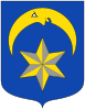
Coat of arms
The emblem represents a six points star of or surmounted by an or overturned crescent on azure background. The origin of the coat is not known but derives from that of Lords of Eppan. The arms were granted in 1929.[4]
Society
Linguistic distribution
According to the 2011 census, 96.37% of the population speak German, 3.44% Italian and 0.20% Ladin as first language.[5]
Demographic evolution

Twin cities
Tramin is twinned with:
![]() Rödermark, since 1978
Rödermark, since 1978
![]() Mindelheim, since 1994
Mindelheim, since 1994
![]() Schwaz, since 1998
Schwaz, since 1998
References
- ^ "Superficie di Comuni Province e Regioni italiane al 9 ottobre 2011". Italian National Institute of Statistics. Retrieved 16 March 2019.
- ^ "Popolazione Residente al 1° Gennaio 2018". Italian National Institute of Statistics. Retrieved 16 March 2019.
- ^ All demographics and other statistics: Italian statistical institute Istat.
- ^ Heraldry of the World: Tramin
- ^ "Volkszählung 2011/Censimento della popolazione 2011". astat info (38). Provincial Statistics Institute of the Autonomous Province of South Tyrol: 6–7. June 2012. Retrieved 2012-06-14.
External links
- (in German and Italian) Homepage of the municipality
- (in English, German, Italian, and Dutch) Tourist Association of Tramin
- Panoramio Photos of Tramin
![]() Media related to Tramin an der Weinstraße at Wikimedia Commons
Media related to Tramin an der Weinstraße at Wikimedia Commons

| International | |
|---|---|
| National | |