
| Szabolcs County | |
|---|---|
| County of the Kingdom of Hungary (11th century-1526) County of the Eastern Hungarian Kingdom (1526-1570) County of the Kingdom of Hungary (1570-1621) County of the Principality of Transylvania (1621-1629) County of the Kingdom of Hungary (1629-1645) County of the Principality of Transylvania (1645-1648) County of the Kingdom of Hungary (1648-1923, 1938-1946) County of the Second Hungarian Republic (1946-1949) County of the Hungarian People's Republic (1949-1950) | |
 Coat of arms
| |
 | |
| Capital | Nyíregyháza |
| Area | |
| • Coordinates | 47°57′N 21°43′E / 47.950°N 21.717°E |
• 1910 | 4,637 km2 (1,790 sq mi) |
| Population | |
• 1910 | 319,818 |
| History | |
• Established | 11th century |
| 4 June 1920 | |
• Merged into Szabolcs-Ung County | 1923 |
• County recreated (First Vienna Award) | 2 November 1938 |
• Disestablished | 16 March 1950 |
| Today part of | Hungary (4,570 km2) Ukraine (69 km2) |
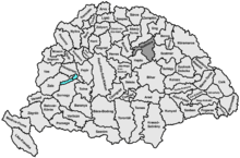
Szabolcs was an administrative county (comitatus) of the Kingdom of Hungary. Its territory is now part of Hungary, except for three villages which are in the Zakarpattia Oblast of Ukraine. The capital of the county was Nyíregyháza.
YouTube Encyclopedic
-
1/3Views:8 80581 7081 368
-
Nyíregyháza - 1perc Magyarország / Nyiregyhaza - 1 minute Hungary
-
502 Hortobágy "Lóra csikós lóra" archive photographs and singing from the Hungarian plain
-
Budapest Keleti: Szabolcs InterCity indul Szolnokon át Nyíregyházára
Transcription
Geography

Szabolcs county shared borders with the counties of Borsod, Zemplén, Ung, Bereg, Szatmár, Bihar and Hajdú. It was situated mostly south of the river Tisza. Its area was 4,637 km2 around 1910.
History
Szabolcs is one of the oldest counties of the Kingdom of Hungary. In the 17th century, the towns of Hajdú separated from the county, creating the Hajdú district. The capital of Szabolcs County was initially Szabolcs (now a village), later Nagykálló took over this role (1747-1867), and since 1867 the capital was moved to Nyíregyháza.
After World War I, it was merged with a very small part of the former Ung County to form Szabolcs-Ung county, with Nyíregyháza as the capital. However, the villages of Eszeny (present-day Esen), Szalóka (present-day Solovka) and Tiszaágtelek (present-day Tisaahtelek) in the Tisza district were passed to Czechoslovakia. These villages were returned to Hungary between 1938 and 1945, but were passed to the Soviet Union afterwards (they are part of Ukraine since 1991). In 1950, the county was disestablished and Szabolcs-Szatmár County was created, which included most of its territory, while some parts of it were passed to the newly created Borsod-Abaúj-Zemplén and Hajdú-Bihar counties (area around Polgár and north-east of Debrecen). In 1990, Szabolcs-Szatmár County was renamed to Szabolcs-Szatmár-Bereg County.
Demographics
Nyíregyháza, the capital of Szabolcs County, was founded around 1750 as a Slovak Lutheran settlement, and had an ethnic Slovak majority until the latter part of the 19th century, when the population became Magyarized.[1] Also, Szabolcs County had a sizeable population of Greek Catholics, who were of Ruthenian and Romanian origin and who became almost entirely Magyarized by the end of the 19th century.

| Census | Total | Hungarian | Slovak | Other or unknown |
|---|---|---|---|---|
| 1880[2] | 214,008 | 186,529 (90.83%) | 13,087 (6.37%) | 5,740 (2.80%) |
| 1890[3] | 244,945 | 234,920 (95.91%) | 6,897 (2.82%) | 3,128 (1.28%) |
| 1900[4] | 288,672 | 285,023 (98.74%) | 2,066 (0.72%) | 1,583 (0.55%) |
| 1910[5] | 319,818 | 316,765 (99.05%) | 1,117 (0.35%) | 1,936 (0.61%) |
| Census | Total | Calvinist | Roman Catholic | Greek Catholic | Jewish | Lutheran | Other or unknown |
|---|---|---|---|---|---|---|---|
| 1880 | 214,008 | 84,674 (39.57%) | 54,920 (25.66%) | 39,829 (18.61%) | 20,119 (9.40%) | 14,055 (6.57%) | 411 (0.19%) |
| 1890 | 244,945 | 96,435 (39.37%) | 65,119 (26.59%) | 46,597 (19,02%) | 21,178 (8.65%) | 15,490 (6.32%) | 126 (0.05%) |
| 1900 | 288,672 | 110,942 (38.43%) | 80,509 (27.89%) | 56,515 (19.58%) | 23,277 (8.06%) | 17,239 (5.97%) | 190 (0.07%) |
| 1910 | 319,818 | 121,396 (37.96%) | 90,560 (28.32%) | 63,353 (19.81%) | 25,316 (7.92%) | 18,924 (5.92%) | 269 (0.08%) |
Subdivisions

In the early 20th century, the subdivisions of Szabolcs county were:
| Districts (járás) | |
|---|---|
| District | Capital |
| Dada alsó | Tiszalök |
| Dada felső | Gáva |
| Kisvárda | Kisvárda |
| Ligetalja | Nyíracsád |
| Nagykálló | Nagykálló |
| Nyírbakta | Nyírbakta |
| Nyírbátor | Nyírbátor |
| Nyírbogdány | Kemecse |
| Tisza | Mándok |
| Urban districts (rendezett tanácsú város) | |
| Nyíregyháza | |
Notes
References
- ^ "RELIGIOUS CONFLICT IN NYÍREGYHÁZA – THE DIFFICULTIES OF AN EIGHTEENTH CENTURY SLOVAK SETTLEMENT" (PDF). Pregledni znanstveni članek. Retrieved 2021-10-21.
- ^ "Az 1881. év elején végrehajtott népszámlálás főbb eredményei megyék és községek szerint rendezve, II. kötet (1882)". library.hungaricana.hu. Retrieved 2021-09-28.
- ^ "A Magyar Korona országainak helységnévtára (1892)". library.hungaricana.hu. Retrieved 2021-09-29.
- ^ "A MAGYAR KORONA ORSZÁGAINAK 1900". library.hungaricana.hu. Retrieved 2021-09-29.
- ^ "KlimoTheca :: Könyvtár". Kt.lib.pte.hu. Retrieved 2021-09-29.

| International | |
|---|---|
| National | |