| Shutdown Mountain | |
|---|---|
| Highest point | |
| Elevation | 2,539 ft (774 m) |
| Prominence | 939 ft (286 m)[1] |
| Coordinates | 45°25′03″N 70°11′58″W / 45.417521°N 70.199397°W |
| Geography | |
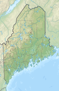
| Location | Somerset County, Maine, U.S. |
| Topo map | USGS Enchanted Pond |
Shutdown Mountain is a mountain located in Somerset County, Maine.[2]
Shutdown Mountain lies within the watershed of the Kennebec River and has two peaks, Shutdown Peak and Bulldog Peak (elevation 2260 ft.), sometimes referred to as Bulldog Mountain. The northern and southern sides of Shutdown Mountain drain into Enchanted Stream, then into the Dead River, a tributary of the Kennebec River. The west side of Shutdown drains into Stony Brook, then into the Dead River. The east side drains into Enchanted Pond, then into Enchanted Stream and into the Dead River.
There is a marked hiking trail (called "Enchanted Lookout") to the top of Bulldog Peak which has a prominence of 817 ft. overlooking Enchanted. The trailhead is located at Bulldog Camps, a traditional Maine sporting camp on the north shore of Enchanted Pond.[3]
YouTube Encyclopedic
-
1/3Views:11 6011 8111 496
-
MULTIPLE STATES GOVERNMENT SHUT DOWN! State Beaches & Parks Are Now CLOSED! Essential Services only
-
Fort Knox State Park Maine
-
A drive on the bridge that separates Maine from New Hampshire on I-95, 11-12-2010
Transcription
References
- ^ Key col elevation 1600 ft. Peakbagger.com. "Shutdown Mountain, Maine". Retrieved 2014-03-24.
- ^ "Shutdown Mountain". Geographic Names Information System. United States Geological Survey, United States Department of the Interior.
- ^ "Bulldog Mountain" Peakbagger, http://www.peakbagger.com/peak.aspx?pid=-31290

