
San Pietro in Cerro | |
|---|---|
| Comune di San Pietro in Cerro | |
 Coat of arms | |
Location of San Pietro in Cerro  | |
 San Pietro in Cerro Location of San Pietro in Cerro in Italy  San Pietro in Cerro San Pietro in Cerro (Emilia-Romagna) | |
| Coordinates: 45°1′N 9°57′E / 45.017°N 9.950°E | |
| Country | Italy |
| Region | Emilia-Romagna |
| Province | Province of Piacenza (PC) |
| Area | |
| • Total | 27.5 km2 (10.6 sq mi) |
| Population (Dec. 2004)[2] | |
| • Total | 962 |
| • Density | 35/km2 (91/sq mi) |
| Time zone | UTC+1 (CET) |
| • Summer (DST) | UTC+2 (CEST) |
| Postal code | 29010 |
| Dialing code | 0523 |
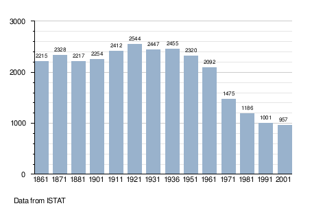
San Pietro in Cerro (Piacentino: San Pédar) is a comune (municipality) in the Province of Piacenza in the Italian region Emilia-Romagna, located about 120 kilometres (75 mi) northwest of Bologna and about 20 kilometres (12 mi) east of Piacenza. As of 31 December 2004, it had a population of 962 and an area of 27.5 square kilometres (10.6 sq mi).[3]
San Pietro in Cerro borders the following municipalities: Caorso, Cortemaggiore, Monticelli d'Ongina, Villanova sull'Arda.
YouTube Encyclopedic
-
1/3Views:651734712
-
II parte Castelli del Ducato: San Pietro in Cerro e i Guerrieri di Terracotta
-
Locanda del Re Guerriero - San Pietro In Cerro - Piacenza - Dimore D'Epoca in Emilia Romagna
-
I Castelli del Piacentino
Transcription
Demographic evolution
References
- ^ "Superficie di Comuni Province e Regioni italiane al 9 ottobre 2011". Italian National Institute of Statistics. Retrieved 16 March 2019.
- ^ "Popolazione Residente al 1° Gennaio 2018". Italian National Institute of Statistics. Retrieved 16 March 2019.
- ^ All demographics and other statistics: Italian statistical institute Istat.

This article on a location in Emilia–Romagna is a stub. You can help Wikipedia by expanding it. |