
Saint-Souplet | |
|---|---|
 A general view of Saint-Souplet | |
 Coat of arms | |
Location of Saint-Souplet  | |
 Saint-Souplet  Saint-Souplet | |
| Coordinates: 50°03′19″N 3°31′53″E / 50.0553°N 3.5314°E | |
| Country | France |
| Region | Hauts-de-France |
| Department | Nord |
| Arrondissement | Cambrai |
| Canton | Le Cateau-Cambrésis |
| Intercommunality | CA Caudrésis–Catésis |
| Government | |
| • Mayor (2020–2026) | Henri Quoniou[1] |
| Area 1 | 12.66 km2 (4.89 sq mi) |
| Population (2021)[2] | 1,203 |
| • Density | 95/km2 (250/sq mi) |
| Time zone | UTC+01:00 (CET) |
| • Summer (DST) | UTC+02:00 (CEST) |
| INSEE/Postal code | 59545 /59360 |
| Elevation | 101–161 m (331–528 ft) |
| 1 French Land Register data, which excludes lakes, ponds, glaciers > 1 km2 (0.386 sq mi or 247 acres) and river estuaries. | |
Saint-Souplet (French pronunciation: [sɛ̃ suplɛ]) is a commune in the Nord department in northern France.[3]
Geography
Saint Souplet-Escaufourt is on the (departmental) route 115. It is part of the Canton of Le Cateau-Cambrésis, 6 km from Cateau, 30 km south east of Cambrai and 86 km from Lille.
Located in the south of Cateau-Cambrésis and on the doorstep of Avesnois, Saint-Souplet is surrounded by the nature landscapes of Hainaut : grasslands bordered by 'bocage' hedges and vast expanses of cultivated fields. It extends along the Selle, a tributary river of the Scheldt, which arises in Aisne and winds some 50 kilomètres through Nord.
History
Saint-Souplet owes its name to its patron saint, Sulpitius the Pious, archbishop of Bourges in the 7th century.
In 1973, it absorbed Escaufourt, located previously in Aisne.[3]
Heraldry
 |
The arms of Saint-Souplet are blazoned : D'or à trois croissants de gueules. These arms are those of D'Anneux, marquis of Wargnies and lords of Saint-Souplet.[4]
|
Demography
| Year | Pop. | ±% p.a. |
|---|---|---|
| 1968 | 1,684 | — |
| 1975 | 1,622 | −0.53% |
| 1982 | 1,482 | −1.28% |
| 1990 | 1,333 | −1.32% |
| 1999 | 1,311 | −0.18% |
| 2007 | 1,284 | −0.26% |
| 2012 | 1,292 | +0.12% |
| 2017 | 1,230 | −0.98% |
| Source: INSEE[5] | ||
Escaufourt

The name Escaufourt comes from fours à chaux (chalk oven). in the 12th century, Escaufourt was in the parish of Honnechy. Before the merger with Saint-Souplet un 1973, Escaufourt was an enclave of Aisne within Nord.
Heraldry
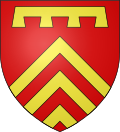 |
The arms of Escaufourt are blazoned :[6] Gules, 3 chevrons, in chief a label of 4 points Or.
|
See also
References
- ^ "Répertoire national des élus: les maires" (in French). data.gouv.fr, Plateforme ouverte des données publiques françaises. 13 September 2022.
- ^ "Populations légales 2021". The National Institute of Statistics and Economic Studies. 28 December 2023.
- ^ a b INSEE commune file
- ^ Source: Cambrésis terre d'histoire
- ^ Population en historique depuis 1968, INSEE
- ^ Dictionnaire historique du département de l'Aisne Par Maximilien Melleville - Publié par M. Melleville, 1865 - p. 362
| International | |
|---|---|
| National | |
This Nord geographical article is a stub. You can help Wikipedia by expanding it. |