
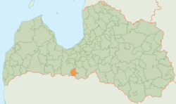
Rundāle Municipality
Rundāles novads | |
|---|---|
 Flag  Coat of arms | |
 | |
| Country | |
| Formed | 2009 |
| Centre | Pilsrundāle |
| Government | |
| • Council Chair | Aivars Okmanis (For People and the Land/NA) |
| Area | |
| • Total | 231.39 km2 (89.34 sq mi) |
| • Land | 227.12 km2 (87.69 sq mi) |
| • Water | 4.27 km2 (1.65 sq mi) |
| Population (2021)[2] | |
| • Total | 3,290 |
| • Density | 14/km2 (37/sq mi) |
| Website | www |
Rundāle Municipality (Latvian: Rundāles novads) is a former municipality in Semigallia, Latvia. The municipality was formed in 2009 by merging Rundāle Parish, Svitene Parish and Viesturi Parish, the administrative centre being Pilsrundāle. The population in 2020 was 3,307.[3]
It was located in the south-east of Latvia and is only 15 km (9.3 mi) from the town Bauska and 80 km (49.7 mi) from Latvian capital Riga.
The centre of the former municipality, Pilsrundāle, is the location of the Rundāle Palace, a famous tourist destination and one of the most notable Latvian chateaus.[citation needed]
On 1 July 2021, Rundāle Municipality ceased to exist and its territory was merged with Bauska Municipality.[4]
YouTube Encyclopedic
-
1/3Views:1 871875663
-
Rundale Palace, Latvia, 4K
-
Rundāle Palace in September 2011 Part I.wmv
-
Visiting Latvia: City-Walk Riga and Palace Rundale
Transcription
See also
References
- ^ Error: Unable to display the reference properly. See the documentation for details.
- ^ Error: Unable to display the reference properly. See the documentation for details.
- ^ "ISG020. Population number and its change by statistical region, city, town, 21 development centres and county". Central Statistical Bureau of Latvia. 2020-01-01. Retrieved 2021-02-12.
- ^ [1] Law on Administrative Territories and Populated Areas
56°25′12″N 24°00′35″E / 56.42000°N 24.00972°E
| Authority control databases: National |
|---|
This Semigallia location article is a stub. You can help Wikipedia by expanding it. |