To install click the Add extension button. That's it.

The source code for the WIKI 2 extension is being checked by specialists of the Mozilla Foundation, Google, and Apple. You could also do it yourself at any point in time.

4,5
Kelly Slayton
Congratulations on this excellent venture… what a great idea!
Alexander Grigorievskiy
I use WIKI 2 every day and almost forgot how the original Wikipedia looks like.
What we do. Every page goes through several hundred of perfecting techniques; in live mode. Quite the same Wikipedia. Just better.
.
Leo
Newton
Brights
Milds

From Wikipedia, the free encyclopedia

Roskow
Location of Roskow within Potsdam-Mittelmark district
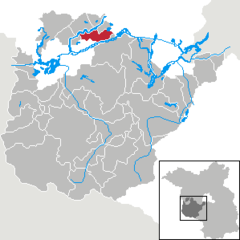
Bad BelzigBeelitzBeetzseeBeetzseeheideBensdorfBorkheideBorkwaldeBrückBuckautalGolzowGörzkeGräbenHavelseeKleinmachnowKloster LehninLintheLintheMichendorfMühlenfließNiemegkNuthetalPäwesinPlanebruchPlanetalRabensteinRosenauRoskowSchwielowseeSeddiner SeeStahnsdorfTeltowTreuenbrietzenWenzlowWerder (Havel)WiesenburgWollinWusterwitzZiesarGroß KreutzBrandenburg
Roskow is located in Germany
Roskow
Roskow
Roskow is located in Brandenburg
Roskow
Roskow
Coordinates: 52°28′00″N 12°43′59″E / 52.46667°N 12.73306°E / 52.46667; 12.73306
CountryGermany
StateBrandenburg
DistrictPotsdam-Mittelmark  
Municipal assoc.Beetzsee
Subdivisions3 Ortsteile
Government
 • Mayor (2019–24) Thomas Schulz[1]
Area
 • Total38.78 km2 (14.97 sq mi)
Elevation
27 m (89 ft)
Population
 (2022-12-31)[2]
 • Total1,186
 • Density31/km2 (79/sq mi)
Time zoneUTC+01:00 (CET)
 • Summer (DST)UTC+02:00 (CEST)
Postal codes
14778
Dialling codes033831
Vehicle registrationPM

Roskow is a municipality in the Potsdam-Mittelmark district, in Brandenburg, Germany.
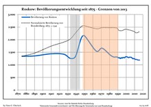
Demography

Development of population since 1875 within the current Boundaries (Blue Line: Population; Dotted Line: Comparison to Population development in Brandenburg state; Grey Background: Time of Nazi Germany; Red Background: Time of communist East Germany)
Roskow: Population development
within the current boundaries (2013)[3]
YearPop.±% p.a.
1875 1,341—    
1890 1,354+0.06%
1910 1,440+0.31%
1925 1,422−0.08%
1933 1,256−1.54%
1939 1,327+0.92%
1946 2,056+6.45%
1950 2,150+1.12%
1964 1,547−2.32%
1971 1,663+1.04%
1981 1,385−1.81%
1985 1,312−1.34%
1989 1,314+0.04%
1990 1,282−2.44%
1991 1,281−0.08%
1992 1,278−0.23%
1993 1,250−2.19%
1994 1,283+2.64%
1995 1,265−1.40%
1996 1,293+2.21%
YearPop.±% p.a.
1997 1,286−0.54%
1998 1,282−0.31%
1999 1,313+2.42%
2000 1,325+0.91%
2001 1,318−0.53%
2002 1,297−1.59%
2003 1,289−0.62%
2004 1,304+1.16%
2005 1,302−0.15%
2006 1,298−0.31%
2007 1,274−1.85%
2008 1,243−2.43%
2009 1,253+0.80%
2010 1,233−1.60%
2011 1,215−1.46%
2012 1,217+0.16%
2013 1,208−0.74%
2014 1,191−1.41%
2015 1,189−0.17%
2016 1,188−0.08%

References

  1. ^ Landkreis Potsdam-Mittelmark Wahl der Bürgermeisterin / des Bürgermeisters, accessed 2 July 2021.
  2. ^ "Bevölkerungsentwicklung und Bevölkerungsstandim Land Brandenburg Dezember 2022" (PDF). Amt für Statistik Berlin-Brandenburg (in German). June 2023.
  3. ^ Detailed data sources are to be found in the Wikimedia Commons.Population Projection Brandenburg at Wikimedia Commons


This page was last edited on 10 June 2022, at 20:33
Basis of this page is in Wikipedia. Text is available under the CC BY-SA 3.0 Unported License. Non-text media are available under their specified licenses. Wikipedia® is a registered trademark of the Wikimedia Foundation, Inc. WIKI 2 is an independent company and has no affiliation with Wikimedia Foundation.