
Pergamos
| |
|---|---|
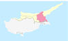
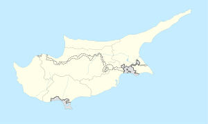 Pergamos Location in Cyprus | |
| Coordinates: 35°2′34″N 33°42′25″E / 35.04278°N 33.70694°E | |
| Country (de jure) | |
| • District | Larnaca District |
| Country (de facto) | |
| • District | Gazimağusa District |
| Government | |
| • Mayor | İlker Edip |
| Population (2011)[2] | |
| • Total | 1,196 |
| • Municipality | 4,125 |
| Time zone | UTC+2 (EET) |
| • Summer (DST) | UTC+3 (EEST) |
| Website | Turkish Cypriot municipality |
Pergamos (Greek: Πέργαμoς; Turkish: Beyarmudu) is a Turkish Cypriot village in Larnaca District, Cyprus, 4 km north of Pyla, almost surrounded by the British Sovereign Base Area (SBA) at Dhekelia.[3] Pergamos is under the de facto control of Northern Cyprus.
Under Ottoman rule it was in the Caza of Famagusta and initially remained so under British rule.[4] Around 1920 it was moved to Larnaca District.[5][6]
YouTube Encyclopedic
-
1/3Views:4 0245 970988
-
Pergamos camp June 2011
-
The Churches of Revelation: Pergamos - The Compromising Church
-
עדותה של רחל ברנהיים על מעצר אוניית המעפילים בה הפליגה
Transcription
Name
The origin of the name is uncertain and may be associated with ancient Pergamon in Asia Minor or Bergamo in the Venice region of Italy. Considering the Venetians settled in Cyprus before the Ottomans, it is highly possible they are the ancestors of the Turkish Cypriots of Pergamos. The Turkish Cypriot name became Beyarmudu in 1958, meaning lord's pear.[3] Pergamos was actually called Pergama and is visible on a map which was published by Jacomo Franco in Venice 1570. Origin of word “Bergamot”: French bergamote, from Italian bergamotta, from Ottoman Turkish bey armudu, lord's pear (equivalent to modern Turkish bey armudu) : bey-lord; see bey + armut, armud-, pear (from Persian amrūd, from Middle Persian ūrmōd) + -u, possessive suff.]
Demographics
Pergamos had a population of 87 in 1881 (first British census).[4] During the British period it was almost solely inhabited by Turkish Cypriots, which it remains.[3] In 1960 there were 826 inhabitants, all Turkish Cypriots.[7] In 2011 the population was 1,196, a slight decrease from 1,270 in 2006.[2] Some Turkish Cypriots who were displaced to Pergamos during the 1960s have remained since in the village.[3]
Current conditions
Apart from the area within the SBA, it lies within the Turkish sector under the De facto control of Northern Cyprus, in the new Famagusta district of the Turkish Cypriots.[3]
Pergamos is the site of a Green Line crossing checkpoint. That and the proximity of the SBA has assisted economic development in the area.[3]
International relations
Twin towns – sister cities
Pergamos is twinned with:
References
- ^ In 1983, the Turkish Republic of Northern Cyprus unilaterally declared independence from the Republic of Cyprus. The de facto state is not recognised by any UN state except Turkey.
- ^ a b KKTC 2011 Nüfus ve Konut Sayımı [TRNC 2011 Population and Housing Census] (PDF), TRNC State Planning Organization, 6 August 2013, p. 19
- ^ a b c d e f PRIO web site http://www.prio-cyprus-displacement.net/default.asp?id=383 retrieved Aug 2018
- ^ a b Census of Cyprus 1881, printed by Eyre & Spottiswoode, London, 1884
- ^ Report and General Abstracts of the Census of Cyprus 1911, publ. Waterlow and Sons Ltd, London, 1912
- ^ Report and General Abstracts of the Census of Cyprus 1921, publ. Waterlow and Sons Ltd, London, 1922
- ^ Census of Population and Agriculture 1960, pub.Printing Office of the Republic of Cyprus, Nicosia, 1960; Vol.1, Table IV
- ^ Sarıyer - Twin Towns, Sarıyer-City.sk, archived from the original on 2013-10-20, retrieved 2013-10-19
- ^ Kepez - Twin Towns, Kepez-City.sk, archived from the original on 2013-10-19, retrieved 2013-10-19
- ^ Karaman - Twin Towns, Karaman-City.sk, retrieved 2013-10-19
| Lefkoşa District | |
|---|---|
| Gazimağusa District | |
| Girne District | |
| Güzelyurt District | |
| İskele District | |
| Lefke District | |

| International | |
|---|---|
| National | |
This Cyprus location article is a stub. You can help Wikipedia by expanding it. |