Perevalne
Перевальне — Перевальное | |
|---|---|
village | |
 Chatyr-Dag near Perevalne. | |
| Coordinates: 44°50′34″N 34°19′21″E / 44.84278°N 34.32250°E | |
| Country | |
| Republic | Crimea |
| District | Simferopol Raion |
| Council | Dobre Village Council |
| Elevation | 438 m (1,437 ft) |
| Population (2001) | |
| • Total | 3,660 |
| Time zone | UTC+4 (MSK) |
| Postal code | 97578 |
| Area code | +380 652 |
| Website | http://rada.gov.ua/ |
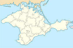
Perevalne (Ukrainian: Перевальне; Russian: Перевальное, romanized: Perevalnoye; Crimean Tatar: Anğara, Ангъара) (until 1945, Angara) is a village in Crimea, a disputed territory recognized by a majority of countries as part of Ukraine but administered by Russia as the Republic of Crimea. The village of Perevalne is administered by the Dobre Village Council, which in turn is subordinate to Crimea's Simferopol Raion (district) authorities.[2]

According to the 2001 Ukrainian census, its population was 3,660.[2] The village is located in the middle of the Crimean Mountains, next to the Chatyr-Dag massif. The Simferopol—Alushta—Yalta highway runs through the village, as well as the Crimean Trolleybus line, which has a stop in the settlement.

There is a garrison (воинская часть A-2320) in Perevalne. There's also a former Soviet training center for special forces. The Ukrainian 36th separate mechanized coastal infantry brigade was located there, and, during the 2014 annexation of Crimea by the Russian Federation, was surrounded by the Russian troops without military rank insignia or cockade.[3][4][5]
YouTube Encyclopedic
-
1/2Views:396162 859
-
Embattled Europe: A Progressive Alternative / Konrad H. Jarausch (Berlin Program July 8, 2020)
-
Poland Buying M1A2 Abrams & K2 Black Panther Tanks? On Top of Their T-72s and PT-91s
Transcription
Russia-Ukraine war
In 2023, several explosions were reported on social media at a military base near Perevalne after one of the war's largest drone attacks allegedly targeting the 126th brigade of the Russian Black Sea Fleet. The attack allegedly caused “...several dozen Russians killed and wounded. Ammunition storage facilities were also damaged. Military equipment was also seriously damaged.” Russian sources denied any casualties or damage.[6]
References
- ^ "Perevalne (Crimea, Simferopol Raion)". weather.in.ua (in Ukrainian). Retrieved 30 January 2012.
- ^ a b "Perevalne, Autonomous Republic of Crimea, Simferopol Raion". Regions of Ukraine and their Structure (in Ukrainian). Verkhovna Rada of Ukraine. Retrieved 30 January 2012.[permanent dead link]
- ^ "- YouTube". YouTube. Archived from the original on 2017-04-10. Retrieved 2016-11-28.
- ^ "36 окрема бригада берегової оборони не здає позиції!!!! (3.03.2014р.)". YouTube.
- ^ "- YouTube". YouTube. Archived from the original on April 12, 2016.
- ^ https://www.kyivpost.com/post/20941
External links
 Media related to Category:Perevalnoe at Wikimedia Commons

