
| Nigali valley | |
|---|---|
| Turkish: Nigali Vadisi Georgian: ნიგალი, ნიგალის ხევი | |
 Nigali valley 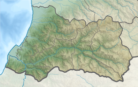 Nigali valley  Nigali valley | |
| Geography | |
| Country | |
| Coordinates | 41°36′11″N 41°34′27″E / 41.60306°N 41.57417°E |
Nigali or the Nigali valley (Georgian: ნიგალი, ნიგალის ხევი, nigalis khevi), also known, through a subsequent metathesis, as Ligani (ლიგანი) or Livana (ლივანა; Turkish: Livâne)[1] is a historical district on the lower course of the Çoruh or Chorokhi river, currently divided between Turkey and Georgia.
History

The land known as Nigal first appears as one of the districts of Colchis in the 7th-century Armenian geography attributed to Ananias of Shirak.[2] In the 8th century, Nigali became part of an appanage of the Georgian Bagratid family. It was bounded by Adjara on the north-east, Shavsheti on the east, and Klarjeti on the south.[1] The medieval Georgian sources also make mention of Niali, which is likely a corruption of Nigali.[3] The early 18th-century Georgian scholar Prince Vakhushti refers to it as Ligani and locates the district on either bank of the Chorokhi as far as Art'vani (now Artvin).[4][5] In c. 1530, the area was conquered from Georgians by the Ottoman Empire, which administered it as the kaza or sanjak of Livâne.[6] It had the sub-district of Maçahel administratively dependent on it.[7]
In 1878, Nigali was part of the territory ceded by the Ottomans to the Russian Empire in the Treaty of Berlin. It was included in the Artvin circuit (uchastok) of the Batum Oblast. Following World War I (1914–1918) and the short-lived independence of Georgia (1918–1921), Nigali was divided between Turkey and recently Sovietized Georgia in accordance with the 1921 treaties of Moscow and Kars.[1][8]
Current division
Currently, the Turkish portion of Nigali comprises parts of the Borçka, Murgul, and Artvin districts of the Artvin Province. The Georgian-speaking element is still present in this area, but knowledge of the Georgian language is weakening among the younger generation.[9][10] The Georgian portion consists of only 9 villages administered as part of the Khelvachauri Municipality of the Autonomous Republic of Adjara.[8]
See also
References
- ^ a b c Toumanoff, Cyril (1963). Studies in Christian Caucasian History, p. 439. Georgetown University Press.
- ^ Hewsen, Robert H. (1992), The Geography of Ananias of Širak: Ašxarhac'oyc', the Long and the Short Recensions, p. 210. Reichert, ISBN 3-88226-485-3
- ^ Rapp, Stephen H. (2003), Studies in Medieval Georgian Historiography: Early Texts And Eurasian Contexts, p. 398. Peeters Publishers, ISBN 90-429-1318-5
- ^ Gugushvili, Andria (1936), "Ethnographical and Historical Division of Georgia". Georgica I, 2-3: 64.
- ^ (in Georgian and French) Wakhoucht (Brosset, Marie-Félicité, transl., 1842) Description géographique de la Géorgie ("Geographic description of Georgia"), p. 115. St. Petersbourg: A la typographie de l'Academie Impériale des Sciences.
- ^ (in Turkish) Sezen, Tahir (2006), Osmanlı yer adları (Alfabetik sırayla) ("Ottoman placenames. Alphabetic list"), p. 349. T.C. Başbakanlık Devlet Arşivleri Genel Müdürlüğü.
- ^ Aktsoglou, Iakovos Z. (2007), "Population in the Province of Trabzon (Vilayet-i Trabzon) According to the Yearbook (Salname) of 1286/1869-70", p. 15, in: Kolovos, Elias et al (eds., 2007), The Ottoman Empire, the Balkans, the Greek lands: toward a social and economic history: studies in honor of John C. Alexander. Gorgias Press & The Isis Press, ISBN 978-1-61719-099-5.
- ^ a b (in Georgian) Beridze, Eter (2009), ნიგალი ("Nigali", with En., Rus., Turk. summaries), pp. 8-10. Shota Rustaveli State University, ISBN 978-9941-409-02-8.
- ^ Bellér-Hann, Ildikó & Hann, C. M. (2001), Turkish Region: State, Market & Social Identities on the East Black Sea Coast, p. 11. James Currey Publishers, ISBN 0852552793.
- ^ (in Russian) Beridze, Eter (2009), Языковая ситуация в Нигальском ущелье ("Linguistic situation in the Nigali valley"). Vlast' i Obshchestvo 1: 71-82.
Subregions of Tao-Klarjeti | ||
|---|---|---|
| Tao |  | |
| Klarjeti | ||
| Samtskhe | ||
| Other | ||