
Newry, Mourne and Down
| |
|---|---|
District | |
 | |
| Sovereign state | United Kingdom |
| Constituent country | Northern Ireland |
| Status | District |
| Incorporated | 1 April 2015 |
| Government | |
| • Type | District council |
| • Body | Newry, Mourne and Down District Council |
| Area | |
| • Total | 629 sq mi (1,628 km2) |
| Population (2022) | |
| • Total | 182,634 |
| • Density | 290/sq mi (110/km2) |
| Time zone | UTC0 (GMT) |
| • Summer (DST) | UTC+1 (BST) |
| ISO 3166 code | GB-NMD |
| Ethnicity | 98.3% White[1] |
| Website | www |
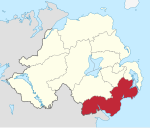
Newry, Mourne and Down is a local government district in Northern Ireland that was created on 1 April 2015 by merging Newry and Mourne District and Down District. It covers most of the southeastern part of Northern Ireland. The local authority is Newry, Mourne and Down District Council. The principle population centres are Newry in the south of the district, and Downpatrick in the north; both these urban areas were seats of previous council areas.
YouTube Encyclopedic
-
1/3Views:1 1911 23524 118
-
Forkhill Park Playground, Newry, Mourne & Down Council
-
Newry | County Down | Northern Ireland | Things To Do In Newry | Visit Newry
-
Killyleagh | County Down | Newry, Mourne and Down | Northern Ireland | Killyleagh Castle
Transcription
Geography
It covers the Southeast of Northern Ireland, including southern County Armagh and large parts of County Down. It incorporates all of the Mourne Mountains and much of the Ring of Gullion, both designated as an Area of Outstanding Natural Beauty. The area has an extensive coastline stretching from Strangford Lough in the north to Carlingford Lough, in the south and borders counties Louth and Monaghan in the Republic of Ireland. The district has a population of 182,634.[2] The name of the new district was announced on 17 September 2008.
Newry, Mourne and Down District Council
Newry, Mourne and Down District Council replaces Newry and Mourne District Council and Down District Council. The first election for the new district council was originally due to take place in May 2009, but in April 2008, Shaun Woodward, Secretary of State for Northern Ireland announced that the scheduled 2009 district council elections were to be postponed until 2011.[3] The first elections took place on 22 May 2014 and the council acted as a shadow authority until 1 April 2015.
References
- ^ [https://www.nisra.gov.uk/system/files/statistics/census-2021-main-statistics-for-northern-ireland-phase-1-statistical-bulletin-ethnic-group.pdf "Main statistics for Northern Ireland Statistical bulletin - Ethnic group"] ONS. Retrieved 22 September 2022
- ^ "Mid-Year Population Estimates, UK, June 2022". Office for National Statistics. 26 March 2024. Retrieved 3 May 2024.
- ^ Northern Ireland elections are postponed, BBC News, April 25, 2008, accessed April 27, 2008
54°06′40″N 6°09′40″W / 54.111°N 6.161°W
This Northern Ireland–related article is a stub. You can help Wikipedia by expanding it. |