
Mueang Phuket
เมืองภูเก็ต | |
|---|---|
 Promthep Cape, southernmost of the district and province | |
 District location in Phuket province | |
| Coordinates: 7°53′24″N 98°23′6″E / 7.89000°N 98.38500°E | |
| Country | Thailand |
| Province | Phuket |
| Seat | Talat Yai |
| Area | |
| • Total | 224.0 km2 (86.5 sq mi) |
| Population (1 January 1992) | |
| • Total | 196,733 |
| • Density | 878.3/km2 (2,275/sq mi) |
| Time zone | UTC+7 (ICT) |
| Postal code | 83000 and 83100 |
| Geocode | 8301 |
Mueang Phuket (Thai: เมืองภูเก็ต, pronounced [mɯ̄a̯ŋ pʰūː.kèt]) is the capital district (amphoe mueang) of Phuket province, Thailand. Phuket town itself is in the district's northeast.
YouTube Encyclopedic
-
1/3Views:3 594 73410 875774
-
Street Food Phuket!! ULTIMATE CRISPY ROTI + Best Thai Food, Beaches, Attractions in Thailand!!
-
Thailand Phuket Panwa Beachfront Resort Muang Mueang Phuket District 5 Sterne
-
Thailand Phuket Panwa Beachfront Resort 5 Sterne Hotel Muang Mueang Phuket District YouTube
Transcription
Geography
The district encompasses the southern part of the island of Phuket. The western and southern coast consists of several heavily used beaches, from the northwest counter-clockwise: Karon, Kata, Kata Noi, Nai Han, Rawai, and Friendship Beach along Chalong Bay. The beaches are separated from each other by rocky capes, most notably Phromthep Cape at the southernmost tip of the island.
History
Originally named Thung Kha (ทุ่งคา), it was renamed Mueang Phuket on 14 November 1938.[1]
Temples

The most important of the 29 Buddhist temples of Phuket is Wat Chalong (วัดฉลอง or, more formally, วัดไชยธาราราม). It is dedicated to two venerated monks, Luang Pho Chaem (หลวงพ่อแช่ม) and Luang Pho Chuang (หลวงพ่อช่วง), who, with their knowledge of herbal medicine, helped those injured in a tin miners rebellion in 1876.
Administration
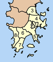
The district is divided into eight sub-districts (tambons), which are further subdivided into 44 villages (mubans). The town of Phuket has city status (thesaban nakhon) and covers tambons Talad Yai and Talad Nuea; Karon, Ratsada, Rawai, and Wichit have sub-district municipality status (thesaban tambon) and each cover the complete same-named tambon. Chalong and Ko Kaeo have a tambon administrative organizations (TAO).
|
|
References
- ^ พระราชกฤษฎีกาเปลี่ยนนามจังหวัด และอำเภอบางแห่ง พุทธศักราช ๒๔๘๑ (PDF). Royal Gazette (in Thai). 55 (ก): 658. November 14, 1938. Archived from the original (PDF) on November 8, 2011.
External links
 Phuket travel guide from Wikivoyage
- amphoe.com
- Wat Chalong Video