
| Département de Montenotte | |||||||||
|---|---|---|---|---|---|---|---|---|---|
| department of the First French Empire | |||||||||
| 1805–1815 | |||||||||
 Flag | |||||||||
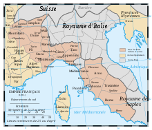 Administrative map of the Italian portion of the French Empire. | |||||||||
| Capital | Savona | ||||||||
| Area | |||||||||
| • Coordinates | 44°18′N 8°29′E / 44.300°N 8.483°E | ||||||||
• 1810[1] | 3,937.98 km2 (1,520.46 sq mi) | ||||||||
| Population | |||||||||
• 1810[1] | 289,823 | ||||||||
| History | |||||||||
• Annexion from the Ligurian Republic | 4 June 1805 | ||||||||
| 1815 | |||||||||
| Political subdivisions | 4 Arrondissements[1] | ||||||||
| |||||||||
Montenotte (French: [mɔ̃.tə.nɔt]) was a department of the First French Empire in present-day Italy. It was named after the village Montenotte near Savona to commemorate the Battle of Montenotte in 1796. It was formed in 1805, when the Ligurian Republic (formerly the Republic of Genoa) was annexed directly to France. Its capital was Savona.
The department was disbanded after the defeat of Napoleon in 1814. It was followed by a brief restoration of the Ligurian Republic, but at the Congress of Vienna the old territory of Genoa was awarded to the Kingdom of Sardinia. Its territory is now divided between the Italian provinces of Savona, Alessandria, Imperia and Cuneo.
Subdivision

The department was subdivided into the following arrondissements and cantons (situation in 1812):[2]
- Savona, cantons: Cairo, Finale, Pietra, Noli, Quiliano, Sassello, Savona and Varazze.
- Acqui, cantons: Acqui, Castelletto d'Orba, Dego, Incisa, Nizza Monferrato, Santo Stefano Belbo, Spigno and Visone.
- Ceva, cantons: Calizzano, Ceva, Dogliani, Garessio, Millesimo, Murazzano, Ormea and Saliceto.
- Porto Maurizio, cantons: Alassio, Albenga, Borgomaro, Diano Marina, Oneglia, Pieve di Teco, Porto Maurizio and Santo Stefano.
Its population in 1812 was 289,823, and its area was 393,798 hectares.[2]
References
- ^ a b "L'ALMANACH IMPÉRIAL POUR L'ANNÉE 1810, CHAPITRE X, Sect. II, Marne - Nord". Retrieved 2010-09-28.
- ^ a b Almanach Impérial an bissextil MDCCCXII, p. 438-439, accessed in Gallica 26 July 2013 (in French)
| Ionian Islands | |
|---|---|
| Austrian Netherlands | |
| Old Swiss Confederacy | |
| Kingdom of Holland | |
| Holy Roman Empire | |
| Italian states | |
| Kingdom of Spain | |
| Austrian Empire |
|
This article about government in France is a stub. You can help Wikipedia by expanding it. |