

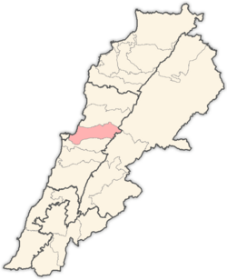


Matn (Arabic: قضاء المتن, Qaḍāʾ al-Matn), sometimes spelled Metn (or preceded by the article El, as in El Matn), is a district (qadaa) in the Mount Lebanon Governorate of Lebanon, east of the Lebanon's capital Beirut. The district capital is Jdeideh (followed to Jdeideh, Bouchrieh, El Sedd Municipality).
Matn is one of the most popular areas in Lebanon, with its rich scenery and its splendid view of the Mediterranean. Matn's population is almost entirely Christian with some Druze in the region, mostly in Beit Mery, Broummana, Mtein and Zarooun.
The Matn district is also popularly known as Northern Matn District (قضاء المتن الشمالي Qaḍāʾ al-Matn aš-Šamāliyy) not to be confused with Southern Matn (المتن الجنوبي al-Matn al-Janūbī) which is part of Baabda District and with Uppermost Matn (المتن الأعلى al-Matn al-ʾAʿlā) which is part of Baabda District.
YouTube Encyclopedic
-
1/5Views:7786 4673 7264755 991
-
Dbayeh, Lebanon -- The MOST CONVENIENT area in Lebanon (Near Beirut in Matn District)
-
Bourj Hammoud -- Beirut, Lebanon's Little ARMENIA (The City of Life)
-
LIVE Weather Feed: Sunday Morning in Beautiful Lebanon (17 Jan 2021). Mtayleb, Metn, Mount Lebanon
-
Saint RAFQA Lebanon
-
ASHRAFIEH, Lebanon -- The Cutest, Most Charming District of Beirut?
Transcription
Municipalities
| Municipality | Arabic name | Area (km²) | Pop. |
|---|---|---|---|
| Bsalim - Mezher - Majzoub | بصاليم - مزهر - المجذوب | ||
| Mazraat Yachouh | مزرعة يشوع | ||
| Wadi el Karem | وادي الكرم | ||
| Ain el Safssaf - Mar Michael Bnabil | عين الصفصاف - مار مخايل بنابيل | ||
| Mar Chaaya & Mzekkeh | مار شعيا والمزكة | ||
| Ghabeh | الغابة | ||
| Majdel Tarchich | مجدل ترشيش | ||
| Fanar | الفنار | ||
| Beit Chabab - Chaouiyeh & Qonaytrah | بيت شباب - الشاوية والقنيطرة | ||
| Qonnabat Broummana | قنابة برمانا | ||
| Dahr el Sawan | ضهر الصوان | ||
| Mtein & Mchikha | المتين ومشيخا | ||
| Jal el Dib - Bkenneya | جل الديب - بقنايا | ||
| Antelias - Naccache | انطلياس - النقاش | ||
| Biakout | بياقوت | ||
| Bikfaya - Mhaydseh, Matn | بكفيا - المحيدثة | ||
| Baskinta | بسكنتا | ||
| Bteghrine | بتغرين | ||
| Dbayeh - Zouk al Khrab - Haret al Ballaneh - Aoukar | الضبية - ذوق الخراب - حارة البلانة - عوكر | ||
| Dhour El Choueir - Ain el Sendianeh | ضهور الشوير - عين السنديانة | ||
| Douar | الدوار | ||
| Dik El Mehdi | ديك المحدي | ||
| Ouyoun | العيون | ||
| Kfarakab | كفرعقاب | ||
| Ain Saadeh - Beit Mery | بيت مري - عين سعادة | ||
| Baabdat | بعبدات | ||
| Jdeideh - Bauchrieh - Sed el Bauchrieh | الجديدة - البوشرية - السد | ||
| Mrouj | المروج | ||
| Aintoura | عينطورة | ||
| Kaakour | القعقور | ||
| Kfartay | كفرتيه | ||
| Ghabet Bologna - Wata el Mrouj | غابة بولونيا - وطى المروج | ||
| Ayroun | عيرون | ||
| Sin el Fil | سن الفيل | ||
| Broummana | برمانا | ||
| Zakrit | زكريت | ||
| Mansourieh - Mkalles - Daychounieh | المنصورية - المكلس - الديشونية | ||
| Cornet Chahwan - Ain Aar - Beit El Kikko & Hbous | قرنة شهوان - عين عار - بيت الككو والحبوس | ||
| Zarooun | زرعون | ||
| Sakiyat al Mesek - Bhersaf | ساقية المسك - بحرصاف | ||
| Mar Moussa - Douar | مار موسى - الدوار | ||
| Khenchara & Jouar | الخنشارة والجوار | ||
| Bourj Hammoud - Dora | برج حمود - الدورة | ||
| Zalka - Amaret Chalhoub | الزلقا - عمارة شلهوب | ||
| Nabay | نابيه | ||
| Marjaba | مرجبا | ||
| Rabieh | الرابية | ||
| Biyada | البياضة | ||
| Mtayleb | مطيلب | ||
| Beit el Chaar & Hadirah | بيت الشعار والحضيرة | ||
| Roumieh | رومية | ||
| Dekwaneh - Mar Roukouz - Daher al Hosein | الدكوانة - مار روكز - ضهر الحصين | ||
| Jouret el ballout | جورة البلوط |
| Akkar Governorate | ||
|---|---|---|
| Baalbek-Hermel Governorate | ||
| Beirut Governorate | ||
| Mount Lebanon Governorate | ||
| North Governorate | ||
| Beqaa Governorate | ||
| South Governorate | ||
| Nabatieh Governorate | ||
Capital: Jdeideh | ||
| Towns and villages |
|  |
| Notable landmarks | ||
| Notable sites | ||
33°53′48″N 35°34′40″E / 33.8967°N 35.5778°E