


Marowijne (Dutch pronunciation: [ˌmaːroːˈʋɛi̯nə]) is a district of Suriname, located on the north-east coast. Marowijne's capital city is Albina, with other towns including Moengo and Wanhatti. The district borders the Atlantic Ocean to the north, French Guiana to the east, the Surinamese district of Sipaliwini to the south, and the Surinamese districts of Commewijne and Para to the west.[2]
Marowijne's population is 18,294 and the district has an area of 4,627 km2.[1]
YouTube Encyclopedic
-
1/3Views:98614 526369
-
Met de boot op de Marowijne Rivier in Suriname - Boattrip on the Maroni River in Suriname,
-
Suriname - Albina - TRIS 1967
-
Moengo Suriname
Transcription
History
Marowijne is also home to many Maroon palenques. The Maroons are descendants of slaves who escaped from their Dutch masters centuries ago, particularly slaves who escaped from Suriname's huge plantations during the 18th century. They established autonomy for their interior settlements by a 1760 peace treaty with the Netherlands, which was unable to conquer them.[3]
Albina was founded on 13 December 1845 by August Kappler, and was named after his wife. Albina is located near the border with French Guiana. It is the main city, and the largest area which is not tribal.[4]
During the early 20th century, bauxite was discovered in Marowijne district, leading to a boom in mining that significantly enriched the entire country.[2] The bauxite industry resulted in the growth of Moengo[5] which is as of 2020, the largest town in the district.[1]
On 22 July 1986, the Surinamese Interior War started. That night, the Jungle Commando led by Ronnie Brunswijk, captured the check post near Stolkertsijver, and opened fire on the army barracks in Albina.[6] The civil war which followed led to the massacre of Moiwana where 35 civilians including women and children were killed by the National Army led by Dési Bouterse,[7] and large scale destruction in Albina and Moengo.[8] The civil war also resulted in a refugee crisis into French Guiana.[8]
The district also has a large tourism industry and is the location of ocean front resorts in Galibi,[9] which is inhabited by an indigenous population.[1]
The main road for Marowijne is the East-West Link. The distance between Paramaribo and Albina is about 150 kilometres (95 mi).[10]
Health care
Four health cares centre are located in the District, and there is a regional medical centre in Albina which qualifies as a minor hospital, however specialised health care has to be performed in Paramaribo or French Guiana. In corporation with the French Development Agency and the Inter-American Development Bank a hospital is under construction in Albina.[11]
Resorts
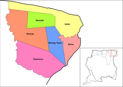
Marowijne is divided into six resorts (ressorten):
- Albina (integral part of Suriname)
- Galibi (indigenous area)
- Moengo (Maroon autonomous area)
- Moengotapoe (Maroon autonomous area)
- Patamacca (Maroon autonomous area)
- Wanhatti (Maroon autonomous area)
Villages
- Alfonsdorp
- Bigiston
- Christiaankondre
- Langamankondre
- Lantiwei
- Moiwana
- Ovia Olo
- Pikin Santi
- Pinatjaimi
- Ricanau Mofo
- Tamarin
References
- ^ a b c d "Resorts in Suriname Census 2012" (PDF). Retrieved 21 May 2020.
- ^ a b "Distrikt Marowijne". Suriname.nu (in Dutch). Retrieved 21 May 2020.
- ^ "The Ndyuka Treaty Of 1760: A Conversation with Granman Gazon". Cultural Survival Quarterly. Retrieved 21 May 2020.
- ^ "Encyclopaedie van Nederlandsch West-Indië - Page 398 - Kappler (August)" (PDF). Digital Library for Dutch Literature (in Dutch). 1916. Retrieved 19 May 2020.
- ^ "Overview of Alcoa in Suriname". Alcoa. Retrieved 2013-04-26.
- ^ "Leger Suriname zoekt gijzelaars". Reformatorisch Dagblad via Delpher. 26 July 1986. Retrieved 21 May 2020.
- ^ "Suriname 2003 report". Amnesty International via web.archive.org. Archived from the original on 22 February 2006. Retrieved 21 May 2020.
- ^ a b "Distrikt Marowijne". Suriname.nu (in Dutch). Retrieved 21 May 2020.
- ^ "Galibi Tour naar Galibi Zeeschildpadden". Galibi Suriname (in Dutch and English). Retrieved 19 May 2020.
- ^ "Transport". Ministry of Transport, Communication and Tourism (in Dutch). Retrieved 19 May 2020.
- ^ "STRUCTUUR ANALYSE DISTRICTEN 2009-2013" (PDF). Planning Office Suriname (in Dutch). Retrieved 22 May 2020.
External links
- District Marowijne at Suriname.nu (in Dutch)
| Brokopondo District |  | |
|---|---|---|
| Commewijne District | ||
| Coronie District | ||
| Marowijne District | ||
| Nickerie District | ||
| Para District | ||
| Paramaribo District | ||
| Saramacca District | ||
| Sipaliwini District | ||
| Wanica District | ||
| Authority control databases: Geographic |
|---|
5°46′14″N 54°19′29″W / 5.77056°N 54.32472°W