
Malda | |
|---|---|
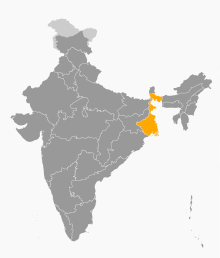
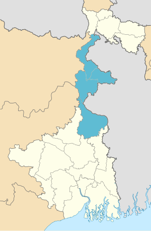 Location of Malda in West Bengal | |
 Interactive Map Outlining Malda | |
| Country | |
| State | |
| Established | 2016 |
| Capital | Malda |
| Districts | Dakshin Dinajpur, Malda, Murshidabad, Uttar Dinajpur |
| Area | |
| • Total | 14,418 km2 (5,567 sq mi) |
| Population (2011) | |
| • Total | 15,773,557 |
| • Density | 1,100/km2 (2,800/sq mi) |
Malda Division is an administrative division within the Indian state of West Bengal. This division was earlier a part of Jalpaiguri division and was carved out from it in 2016.[1] The headquarters and the largest city of the Malda Division is Malda. The office of divisional commissioner is temporary located in old circuit house at B. G. Road, Malda.
YouTube Encyclopedic
-
1/5Views:99677796 1831 8987 965
-
ALP & Loco Pilot crew lobby, Malda division [Eastern Railway]
-
Malda division Documents Fillup बिल्कुल आसान तरीके से समझे RRC ER 2023#viral #video #viral_video
-
मालदा टाउन रेलवे स्टेशन की सच्चाई नहीं जानते होंगे !!!! | malda town railway station | west bengal
-
MALDA DIVISION EASTERN RAILWAYEXAM PAPER-15/01/2023 LDCE RAILWAY DEPARTMENT EXAM PAPER GOODS GUARD
-
Eastern Railway Zone and all its Division Through MAP पूर्वी रेलवे जोन में आने वाले डिवीज़न और स्टेशन
Transcription
Districts
It consists of 4 districts:[2]
| Code | District | Headquarters | Area | Population As of 2011 | Population Density | Map |
|---|---|---|---|---|---|---|
| MA | Malda | Malda | 3,733 km2(1,441 sq mi) | 3,997,970 | 1,100/km2 (2,800/sq mi) |  |
| MU | Murshidabad | Baharampur | 5,324 km2(2,056 sq mi) | 7,103,807 | 1,334/km2 (3,460/sq mi) |  |
| ND | Uttar Dinajpur | Raiganj | 3,142 km2 (1,213 sq mi) | 3,000,849 | 960/km2 (2,500/sq mi) |  |
| SD | Dakshin Dinajpur | Balurghat | 2,219 km2 (857 sq mi) | 1, 670,931 | 750/km2 (2,000/sq mi) |  |
| Total | 4 | — | 14,418 km2
(5,567 sq mi) |
15,773,557 | 4,177 km2
(10,760/sq mi) |
 |
Demographics
Religion in Malda Division (2011 Indian Census)
Islam (60.94%)
Hinduism (38.20%)
Others or no religion (0.80%)
Malda division is the only division of West Bengal where Muslims forms the majority of the population. Muslims numbering 9,612,405, comprises 60.94% of the population, whereas Hindus numbering 6,025,498, forms 38.20% of the division's population.[3]
See also
References
- ^ "Bengal to be divided into two more administrative divisions". millenniumpost.in. 2016-11-22.
- ^ "The State : West Bengal". brandbharat.com. Retrieved 2020-08-02.
- ^ Population by religious community: West Bengal. 2011 Census of India.