To install click the Add extension button. That's it.

The source code for the WIKI 2 extension is being checked by specialists of the Mozilla Foundation, Google, and Apple. You could also do it yourself at any point in time.

4,5
Kelly Slayton
Congratulations on this excellent venture… what a great idea!
Alexander Grigorievskiy
I use WIKI 2 every day and almost forgot how the original Wikipedia looks like.
Live Statistics
English Articles
Improved in 24 Hours
Added in 24 Hours
Languages
Recent
Show all languages
What we do. Every page goes through several hundred of perfecting techniques; in live mode. Quite the same Wikipedia. Just better.
.
Leo
Newton
Brights
Milds

List of parishes of the Isle of Man

From Wikipedia, the free encyclopedia

Sheadings and districts of the Isle of Man.

The Isle of Man, a self-governing British Crown Dependency, in the Irish Sea has 17 historic parishes and was, until May 2016 divided into 24 districts for administrative purposes. These were 15 remaining parishes, 4 towns and 5 villages, each forming the lowest unit of local government in the Isle of Man.[1]

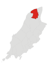
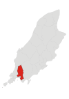
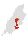
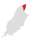
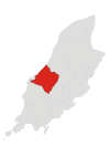
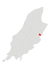
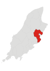
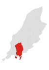
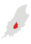
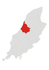
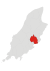
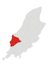
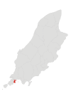
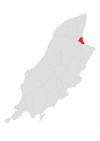
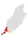
In May 2016, the three districts of Laxey, Lonan and Maughold merged for administrative purposes to form the parish district of Garff. In 2020. the two parish districts of Arbory and Rushen merged for administrative purposes to form the parish district of Arbory and Rushen. The total number of administrative districts thus reduced to 21, made up of:

  • four towns
  • two "districts" (Michael and Onchan, both of which are historically parishes)
  • two "village districts" (Port Erin and Port St Mary)
  • and 13 "parish districts" (including Garff, which is made up of two historical parishes: Lonan and Maughold).[2]

YouTube Encyclopedic

  • 1/5
    Views:
    653 726
    10 080
    15 660
    1 858 853
    330 840
  • Languages of the British Isles
  • 20 Unmissable Resources for Tracing British and Irish Ancestors | Findmypast
  • PARISH PROFILE: CLARENDON, JAMAICA
  • MORNING BLESSINGS | Morning Prayer To Start Your Day - 1 Hour Morning Inspiration to Motivate You
  • Abuse in the Catholic Church | DW Documentary

Transcription

Parishes and other units

Image Name Status[1] Sheading Population[1] Coordinates Map
Andreas Parish Ayre 1397 54°22′N 4°26′W / 54.367°N 4.433°W / 54.367; -4.433 (Andreas)
Arbory Parish Rushen 1847 54°6′N 4°41′W / 54.100°N 4.683°W / 54.100; -4.683 (Arbory)
Ballaugh Parish Michael 1,032 54°19′N 4°33′W / 54.317°N 4.550°W / 54.317; -4.550 (Ballaugh)
Braddan Parish Middle 3,621 54°9′N 4°30′W / 54.150°N 4.500°W / 54.150; -4.500 (Braddan)
Bride Parish Ayre 382 54°23′N 4°24′W / 54.383°N 4.400°W / 54.383; -4.400 (Bride)
Castletown Town Rushen 3,216 54°4′N 4°39′W / 54.067°N 4.650°W / 54.067; -4.650 (Castletown)
Douglas City Middle 26,997 54°9′N 4°29′W / 54.150°N 4.483°W / 54.150; -4.483 (Douglas)
German Parish Glenfaba 966 54°13′N 4°41′W / 54.217°N 4.683°W / 54.217; -4.683 (German)
Jurby Parish Michael 776 54°21′N 4°33′W / 54.350°N 4.550°W / 54.350; -4.550 (Jurby)
Laxey Village Garff 1,676 54°14′N 4°24′W / 54.233°N 4.400°W / 54.233; -4.400 (Laxey)
Lezayre Parish Ayre 1,276 54°19′N 4°25′W / 54.317°N 4.417°W / 54.317; -4.417 (Lezayre)
Lonan Parish Garff 1,579 54°11′N 4°25′W / 54.183°N 4.417°W / 54.183; -4.417 (Lonan)
Malew Parish Rushen 2,167 54°6′N 4°39′W / 54.100°N 4.650°W / 54.100; -4.650 (Malew)
Marown Parish Middle 2,246 54°11′N 4°34′W / 54.183°N 4.567°W / 54.183; -4.567 (Marown)
Maughold Parish Garff 985 54°18′N 4°19′W / 54.300°N 4.317°W / 54.300; -4.317 (Maughold)
Michael Parish Michael 1,591 54°17′N 4°35′W / 54.283°N 4.583°W / 54.283; -4.583 (Michael)
Onchan Parish Middle 9,128 54°10′N 4°27′W / 54.167°N 4.450°W / 54.167; -4.450 (Onchan)
Patrick Parish Glenfaba 1,576 54°12′N 4°42′W / 54.200°N 4.700°W / 54.200; -4.700 (Patrick)
Peel Town Glenfaba 5,374 54°13′N 4°41′W / 54.217°N 4.683°W / 54.217; -4.683 (Peel)
Port Erin Village Rushen 3,484 54°5′N 4°45′W / 54.083°N 4.750°W / 54.083; -4.750 (Port Erin)
Port St Mary Village Rushen 1,916 54°4′N 4°44′W / 54.067°N 4.733°W / 54.067; -4.733 (Port St Mary)
Ramsey Town Garff 7,845 54°19′N 4°23′W / 54.317°N 4.383°W / 54.317; -4.383 (Ramsey)
Rushen Parish Rushen 1,537 54°5′N 4°45′W / 54.083°N 4.750°W / 54.083; -4.750 (Rushen)
Santon Parish Middle 700 54°7′N 4°35′W / 54.117°N 4.583°W / 54.117; -4.583 (Santon)

References

  1. ^ a b c "General Population Statistics" (PDF), Isle of Man Census Report 2006, Economic Affairs Division, Isle of Man Government Treasury, p. 14, archived from the original (PDF) on 5 March 2016
  2. ^ "Isle of Man Government - Local authorities".
This page was last edited on 25 May 2024, at 00:25
Basis of this page is in Wikipedia. Text is available under the CC BY-SA 3.0 Unported License. Non-text media are available under their specified licenses. Wikipedia® is a registered trademark of the Wikimedia Foundation, Inc. WIKI 2 is an independent company and has no affiliation with Wikimedia Foundation.