To install click the Add extension button. That's it.

The source code for the WIKI 2 extension is being checked by specialists of the Mozilla Foundation, Google, and Apple. You could also do it yourself at any point in time.

4,5
Kelly Slayton
Congratulations on this excellent venture… what a great idea!
Alexander Grigorievskiy
I use WIKI 2 every day and almost forgot how the original Wikipedia looks like.
What we do. Every page goes through several hundred of perfecting techniques; in live mode. Quite the same Wikipedia. Just better.
.
Leo
Newton
Brights
Milds

List of airports in Azerbaijan

From Wikipedia, the free encyclopedia

Map of Azerbaijan

This is a list of airports in Azerbaijan, grouped by type and sorted by location.

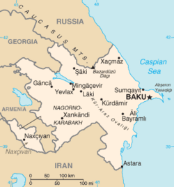
Azerbaijan, formally the Republic of Azerbaijan (Azerbaijani: Azərbaycan Respublikası), is a country in the Caucasus region of Eurasia. It is bounded by the Caspian Sea to the east, Russia to the north, Georgia to the northwest, Armenia to the west, and Iran to the south. The exclave of Nakhchivan is bounded by Armenia to the north and east, Iran to the south and west, while having a short borderline with Turkey to the northwest. The country's capital city is Baku. Air transportation in Azerbaijan is regulated by the Ministry of Transportation of Azerbaijan Republic.

A$40 million project to lengthen the main runway at Ganja Airport has been completed, allowing the first international direct connections to the city. Similar projects are underway at Lenkoran and Zaqatala and due for completion in 2007.[1][2]

YouTube Encyclopedic

  • 1/5
    Views:
    12 894 824
    2 220 840
    10 223 706
    639 048
    2 040 311
  • European Map: Countries, Capitals and National Flags (with Photos). Learn Geography #01
  • Top 10 Most Hated Countries in the World
  • Poorest Asian Countries : GDP Per Capita (1960 - 2021)
  • Countries Ranked by Military Strength 2022
  • 25 Countries With The Highest Rate of Atheism.

Transcription

Airports

Names shown in bold indicate the airport has scheduled passenger service on commercial airlines.

City served ICAO DAFIF IATA Airport name Coordinates
Public airports
Ağdam (Agdam) UBEA Agdam Airport 39°58′33″N 47°0′0″E / 39.97583°N 47.00000°E / 39.97583; 47.00000 (Agdam Airport)
Agjabedi UBEY Agjabedi Airport 40°1′20″N 47°26′57″E / 40.02222°N 47.44917°E / 40.02222; 47.44917 (Agdam Airport)
Ağstafa (Agstafa) UBBA UB17 Akstafa Airport 41°07′24″N 045°25′17″E / 41.12333°N 45.42139°E / 41.12333; 45.42139 (Akstafa Airport)
Baku UBBB GYD Heydar Aliyev International Airport 40°28′03″N 050°02′48″E / 40.46750°N 50.04667°E / 40.46750; 50.04667 (Heydar Aliyev International Airport)
Baku UBTT ZXT Zabrat Airport 40°29′42″N 049°58′37″E / 40.49500°N 49.97694°E / 40.49500; 49.97694 (Zabrat Airport (Baku))
Baku UBLL Lokbatan Airport 40°20′59″N 49°40′11″E / 40.34972°N 49.66972°E / 40.34972; 49.66972 (Lokbatan Airport (Baku))
Baku UBBP Pirallahi Heliport 40°25′5″N 50°21′23″E / 40.41806°N 50.35639°E / 40.41806; 50.35639 (Pirallahi Airport)
Baku UBBC  Çilov Heliport 40°32′4″N 50°32′08″E / 40.53444°N 50.53556°E / 40.53444; 50.53556 (Çilov Airport)
Baku UBCH  Central Hospital Heliport 40°39′7″N 49°30′18″E / 40.65194°N 49.50500°E / 40.65194; 49.50500 (Hospital Airport)
Balakən (Balakan) UB0G UB16 Balakan Airport 41°45′12″N 046°21′19″E / 41.75333°N 46.35528°E / 41.75333; 46.35528 (Balakan Airport)
Fuzuli UBBF FZL Fuzuli International Airport 39°59′44″N 47°19′6″E / 39.99556°N 47.31833°E / 39.99556; 47.31833 (Fizuli International Airport)
Ganja UBBG GNJ Ganja International Airport 40°44′15″N 046°19′03″E / 40.73750°N 46.31750°E / 40.73750; 46.31750 (Ganja International Airport (Ganja))
Hajiqabul UBBM Hajiqabul Airport 40°2′7″N 48°54′36″E / 40.03528°N 48.91000°E / 40.03528; 48.91000 (Hajiqabul Airport)
Khachmaz UBBH Khachmaz Airport 41°45′16″N 48°26′01″E / 41.75444°N 48.43361°E / 41.75444; 48.43361 (Khachmaz Airport)
Khankendi (Stepanakert) UBBS UB13 Khojali Airport (public) 39°54′05″N 046°47′13″E / 39.90139°N 46.78694°E / 39.90139; 46.78694 (Stepanakert Airport)
Lachin - - - Lachin International Airport (under construction) 39°52′45″N 046°20′48″E / 39.87917°N 46.34667°E / 39.87917; 46.34667 (Lachin International Airport)
Lankaran UBBL UB10 LLK Lankaran International Airport 38°44′47″N 048°49′04″E / 38.74639°N 48.81778°E / 38.74639; 48.81778 (Lankaran International Airport)
Naftalan UBEN Naftalan Airport 40°30′57″N 46°49′46″E / 40.51583°N 46.82944°E / 40.51583; 46.82944 (Naftalan Airport)
Nakhchivan UBBN UB15 NAJ Nakhchivan International Airport (public / military) 39°11′19″N 045°27′30″E / 39.18861°N 45.45833°E / 39.18861; 45.45833 (Nakhchivan International Airport)
Qabala (Gabala / Qəbələ) UBBQ GBB Qabala International Airport 40°49′36″N 047°42′45″E / 40.82667°N 47.71250°E / 40.82667; 47.71250 (Gabala Airport)
Shaki UBEI Shaki Airport 41°8′11″N 047°9′34″E / 41.13639°N 47.15944°E / 41.13639; 47.15944 (Shaki Airport)
Yevlakh UBEE YLV Yevlakh Airport 40°37′57″N 047°08′28″E / 40.63250°N 47.14111°E / 40.63250; 47.14111 (Yevlakh Airport)
Zangilan UBBZ ZZE Zangilan International Airport 39°5′39.89″N 46°44′2.75″E / 39.0944139°N 46.7340972°E / 39.0944139; 46.7340972 (Zangilan International Airport)
Zaqatala UBBY ZTU Zaqatala International Airport 41°33′44″N 046°40′02″E / 41.56222°N 46.66722°E / 41.56222; 46.66722 (Zaqatala Airport)
Military airports
Baku UB18 Baku Kala Air Base 40°24′23″N 050°12′00″E / 40.40639°N 50.20000°E / 40.40639; 50.20000 (Baku Kala Air Base)
Dəllər (Dollyar) UB11 Dollyar Air Base 40°53′15″N 045°57′25″E / 40.88750°N 45.95694°E / 40.88750; 45.95694 (Dollyar Air Base)
Kürdəmir (Kurdamir) UB14 Kyurdamir Air Base 40°16′24″N 048°09′48″E / 40.27333°N 48.16333°E / 40.27333; 48.16333 (Kyurdamir Air Base)
Sitalçay Sitalchay Military Airbase 40°47′02″N 049°24′02″E / 40.78389°N 49.40056°E / 40.78389; 49.40056 (Sitalchay Air Base)
Sumqayit UBBI UB12 Nasosnaya Air Base 40°35′29″N 049°33′26″E / 40.59139°N 49.55722°E / 40.59139; 49.55722 (Nasosnaya Air Base)

See also

References

  1. ^ Airliner World, February 2007
  2. ^ "Azerbaijan: Building Bridges for President Aliyev's Re-Election?". EurasiaNet. 30 May 2007.

External links


This page was last edited on 28 March 2024, at 19:11
Basis of this page is in Wikipedia. Text is available under the CC BY-SA 3.0 Unported License. Non-text media are available under their specified licenses. Wikipedia® is a registered trademark of the Wikimedia Foundation, Inc. WIKI 2 is an independent company and has no affiliation with Wikimedia Foundation.