
Kaspi Municipality
კასპის მუნიციპალიტეტი | |
|---|---|
 a village in Kaspi municipality | |
 Flag  Seal | |
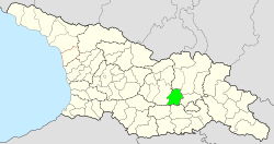 Location of Kaspi Municipality in Georgia | |
| Country | |
| Region | Shida Kartli |
| Capital | Kaspi |
| various | 1 town, 71 villages |
| Area | |
| • Total | 802 km2 (310 sq mi) |
| Population (2014) | |
| • Total | 43,771 |
| • Density | 55/km2 (140/sq mi) |
| Time zone | UTC+4 |
| Website | Official site of shida kartli region |
Kaspi (Georgian: კასპის მუნიციპალიტეტი) is a district of Georgia, in the region of Shida Kartli. Given a District status within Transcaucasian SFSR in 1930. District center is Kaspi.
YouTube Encyclopedic
-
1/1Views:629
-
TRAVEL With Us - Khornabuji; Georgia | იმოგზაურე ჩვენთან ერთად - ხორნაბუჯის ციხე; საქართველო ©
Transcription
Geography
The district occupies Shida Kartli plain, stretching on both sides of the Kura River - bordering southern parts of Greater Caucasus to the North and Trialeti Range to the South. Bigger rivers crossing the District are Kura and Ksani.
District population is 43,771, population density is 55 per km2 (2014). There are 71 villages and 1 town in the District.
District economy is focused on agriculture, there are a few manufactures producing building materials and wine/spirits.
There are a number of historical and architectural sites in the District, including Rkoni Monastery, Samtavisi and Kvatakhevi churches.

Kavtiskhevi kurgans
Near the village of Kavtiskhevi in Kaspi Municipality some very ancient kurgans have been found. They were excavated by Makharadze in 2007.
Materials recovered from these excavations can be related to remains from the metal-working Late Chalcolithic site of Leilatepe on the Karabakh steppe.[1] Also, at Soyuqbulaq, Agstafa, there are similar kurgans.
Also, the earliest level at the multi-period site of Berikldeebi in Kvemo Kartli is relevant.[2] These discoveries reveal the presence of early 4th millennium kurgans in the southern Caucasus.[3]
See also
Notes
- ^ Narimanov et al. 2007
- ^ Glonti and Dzavakhishvili 1987
- ^ Origin of Early Transcaucasian Culture. Dienekes' Anthropology blog
External links
- Districts of Georgia, Statoids.com
| Autonomous Republic of Abkhazia | |
|---|---|
| Autonomous Republic of Adjara | |
| Guria | |
| Imereti | |
| Kakheti | |
| Mtskheta-Mtianeti | |
| Racha-Lechkhumi and Kvemo Svaneti | |
| Samegrelo-Zemo Svaneti | |
| Samtskhe-Javakheti | |
| Kvemo Kartli | |
| Shida Kartli | |
| International | |
|---|---|
| National | |
41°55′00″N 44°25′00″E / 41.9167°N 44.4167°E