
Kamareddy district | |
|---|---|
 Temple at Domakonda fort | |
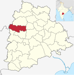 Location in Telangana | |
 Kamareddy district | |
| Country | |
| State | Telangana |
| Headquarters | Kamareddy |
| Mandalas | 23 |
| Government | |
| • District Collector | Shri Jithesh V Patil IAS |
| • Parliament constituencies | 1 |
| Area | |
| • Total | 3,652 km2 (1,410 sq mi) |
| Population (2015) | |
| • Total | 1,004,259 |
| • Density | 277.2/km2 (718/sq mi) |
| Demographics | |
| • Literacy | 56.51 |
| • Sex ratio | 1033 |
| Time zone | UTC+05:30 (IST) |
| Vehicle registration | TS–17[1] |
| Website | kamareddy |
Kamareddy district is a district located in the northern region of the Indian state of Telangana.[2][3] The district shares boundaries with Medak, Nizamabad, Sangareddy, Siddipet and Rajanna Sircilla districts and with the state boundary of Maharashtra and Karnataka.
YouTube Encyclopedic
-
1/1Views:5 488
-
T-SAT || Kamareddy District Information || Telangana 31 Districts
Transcription
Geography
The district is spread over an area of 3,652.00 square kilometres (1,410.05 sq mi) making it the 15th largest district in the state.[4] Kamareddy is bounded by Nizamabad district on North, Rajanna Sircilla and Siddipet districts to the east respectively, it is bounded on South by Sangareddy district and Medak district and on the West and South West by Nanded district and Bidar district of Maharashtra and Karnataka states respectively.
Demographics
As of 2011[update] Census of India, the district has a population of 974,227. Kamareddy district has a sex ratio of 1033 females per 1000 males and a literacy rate of 56.48%. 111,966 (11.50%) was under 10 years of age. 123,622 (12.69%) lived in urban areas. Scheduled Castes and Scheduled Tribes made up 153,678 (15.77%) and 81,956 (8.41%) respectively.[6]
At the time of the 2011 census, 72.87% of the population spoke Telugu, 9.73% Urdu, 8.57% Lambadi, 3.89% Marathi and 3.23% Kannada as their first language.[7]
Administrative divisions
The district has three revenue divisions of Kamareddy and Banswada and Yellareddy are sub-divided into 23 mandals.[4][8] Dr. A. Sharath is the present collector of the district.[9] village Babulgaon formerly under Sangareddy district was restored to Kamareddy district.
| No. | Kamareddy | Banswada | Yellareddy |
|---|---|---|---|
| 1 | Kamareddy | Banswada | Yellareddy |
| 2 | Bhiknoor | Birkur | Nagireddypet |
| 3 | Tadwai | Nasrullabad | Lingampet |
| 4 | Rajampet | Bichkunda | Gandhari |
| 5 | Domakonda | Jukkal | |
| 6 | Bibipet | Pitlam | |
| 7 | Machareddy | Pedda Kodapgal | |
| 8 | Sadashivnagar | Madnoor | |
| 9 | Ramareddy | Nizamsagar | |
| 10 | Palwancha | ||
| 11 | |||
| 12 |
See also
References
- ^ "Telangana New Districts Names 2016 Pdf TS 31 Districts List". Timesalert.com. 11 October 2016. Retrieved 11 October 2016.
- ^ "Kamareddy district" (PDF). Chief Commissioner of Land Administration. Archived from the original (PDF) on 9 September 2016. Retrieved 22 August 2016.
- ^ "New districts map". newdistrictsformation.telangana.gov.in. Retrieved 22 August 2016.[permanent dead link]
- ^ a b "New districts". Andhra Jyothy.com. 8 October 2016. Retrieved 8 October 2016.
- ^ "Table C-01 Population By Religious Community: Andhra Pradesh". Registrar General and Census Commissioner of India.
- ^ District census 2011: Nizamabad by mandals
- ^ a b "Table C-16 Population by Mother Tongue: Andhra Pradesh". Census of India. Registrar General and Census Commissioner of India.
- ^ "Clipping of Andhra Jyothy Telugu Daily – Hyderabad". Andhra Jyothy. Retrieved 8 October 2016.
- ^ "K Chandrasekhar Rao appoints collectors for new districts". Deccan Chronicle. 11 October 2016. Retrieved 13 October 2016.
External links
Places adjacent to Kamareddy district | |
|---|---|