

2
| |
|---|---|
 | |
| Route information | |
| Length | 25.2 km (15.7 mi) |
| Major junctions | |
| North end | SH 104 in Manali |
| NH 5 in Madhavaram NH 205 at Padi Junction SH 112 in Thirumangalam NH 4 at Koyambedu Junction SH 113 in Vadapalani NH 32 at Kathipara Junction | |
| South end | SH 49A in Thiruvanmiyur |
| Location | |
| Country | India |
| Highway system | |
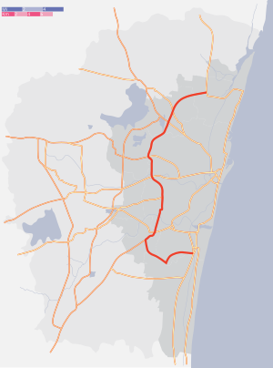
The Inner Ring Road (IRR), also known as Jawaharlal Nehru Salai or 100-Feet road or State Highway 2, is a major transportation corridor encircling the city of Chennai. It was developed by the Chennai Metropolitan Development Authority (CMDA). It is 25.2 km long with three distinct arms viz., Northern arm, Central arm and Southern arm, connecting SH 49A (Rajiv Gandhi Salai) in Tiruvanmiyur, Velachery main road at Vijayanagar, NH 32 (GST road) at Kathipara, NH 4 at Koyambedu, NH 205 at Padi, NH 5 at Madhavaram and joining SH 104 (TPP Road) at Manali.[1]
YouTube Encyclopedic
-
1/5Views:1 090 16949 24110 030 080455 906660 365
-
Diesel engine working function | #Diesel locomotive | How a diesel locomotive works?
-
Bangalore to Chennai Bullet Train
-
New Inventions That Will Take Your Bike To Another Level
-
Hyderabad Outer Ring Road is Telangana's First Expressway
-
भारत के सबसे व्यस्त बस टर्मिनल | Top BUSIEST Bus Terminals in India
Transcription
Details of the corridor
The IRR is a 6-lane road with three arms. The northern arm of IRR starts from Padi Junction and joins SH 104 (TPP) near Manali. It connects NH5 at Madhavaram Junction. The central arm extends from Kathipara Junction and ends at Padi Junction. It connects NH 32 at Kathipara Junction, NH4 at Koyambedu Junction and NH 205 at Padi Junction. The northern and central arms together form State Highway 2. The southern arm of IRR extends from IT corridor in the form of Taramani Link Road and joins NH 32 at Officers Training Academy before ending at Kathipara Junction.[2] The Chennai RBTW is being planned along the Taramani Link Road.
See also
References
- ^ "Waiting for completion of work on Inner Ring Road". The Hindu. 10 July 2006. Archived from the original on 15 July 2006.
- ^ R. Srikanth (15 May 2008). "Inner Ring Road southern extension taking shape". The Hindu. Archived from the original on 22 May 2008.
| Transport by cities | |||||||||
|---|---|---|---|---|---|---|---|---|---|
| Road |
| ||||||||
| Rail |
| ||||||||
| Air |
| ||||||||
| Water |
| ||||||||
| Space |
| ||||||||