
Ilford | |
|---|---|
 IG | |
| Coordinates: 51°35′13″N 0°04′19″E / 51.587°N 0.072°E | |
| Country | United Kingdom |
| Postcode area | IG |
| Postcode area name | Ilford |
| Post towns | 6 |
| Postcode districts | 11 |
| Postcode sectors | 35 |
| Postcodes (live) | 5,979 |
| Postcodes (total) | 10,011 |
| Statistics as at May 2020[1] | |
The IG postcode area, also known as the Ilford postcode area,[2] is a group of eleven postcode districts in England, within six post towns. These cover parts of eastern Greater London and south-west Essex.
YouTube Encyclopedic
-
1/5Views:55 626343 88424 612438 3401 227 448
-
Facebook Ads Location Targeting Tips and Best Practices
-
How to be a Public Figure on Instagram 2020
-
Geomapping zip codes on Google My Maps
-
How to Post Photos on Instagram in Public
-
Gangs of London - Moscow17 v Zone 2
Transcription
Postal administration
Inward mail for the area is sorted, along with mail for the E and RM postcode areas, at the Romford Mail Centre.
Chigwell and Buckhurst Hill are covered by Woodford Green Royal Mail Delivery Office [3]
Coverage
The area served includes much of the London Borough of Redbridge, the western part of the London Borough of Barking and Dagenham, and the southwestern part of the Epping Forest district of Essex, while the western part of IG8 and IG11 covers a small part of the London Borough of Waltham Forest, and the London Borough of Newham.
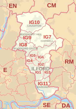
List of postcode districts
The approximate coverage of the postcode districts is as follows:[4]
| Postcode district | Post town | Coverage | Local authority area(s) |
|---|---|---|---|
| IG1 | ILFORD | Ilford, Cranbrook, Loxford (part) | Redbridge |
| IG2 | ILFORD | Gants Hill, Newbury Park, Aldborough Hatch | Redbridge |
| IG3 | ILFORD | Seven Kings, Goodmayes | Redbridge |
| IG4 | ILFORD | Redbridge | Redbridge |
| IG5 | ILFORD | Clayhall | Redbridge |
| IG6 | ILFORD | Fairlop, Barkingside, Chigwell, Hainault (south) | Redbridge |
| IG7 | CHIGWELL | Chigwell, Chigwell Row, Hainault (north) | Epping Forest, Redbridge |
| IG8 | WOODFORD GREEN | Woodford Green, Woodford Bridge, Highams Park (part) | Redbridge, Waltham Forest |
| IG9 | BUCKHURST HILL | Buckhurst Hill | Epping Forest |
| IG10 | LOUGHTON | Loughton, High Beach (part) | Epping Forest |
| IG11 | BARKING | Barking, Barking Riverside, Beckton (part), Creekmouth, Loxford (part), Thames View, Upney | Barking and Dagenham, Newham, Redbridge |
Ilford campaign
In 2005, a local businessman named Wilson Chowdhry led a campaign for Ilford's IG1 postcode to be changed to E19. Although Ilford has been part of Greater London since 1965, it is not within the London post town. Chowdhry argued that the IG1 postcode confused customers, and that a London E postcode would help bring more business into Ilford. However, a Royal Mail spokesman said that the campaign had "virtually no hope" of succeeding, as postcodes are only changed for operational reasons.[5]
A similar plea had been raised in the 1970s by Greater London Council politician Serge Lourie, and similarly rejected. Ilford had been part of the original E division of the London postal district from 1857 until 1866.[6]
Map
See also
References
- ^ "ONS Postcode Directory Version Notes" (ZIP). National Statistics Postcode Products. Office for National Statistics. May 2020. Table 2. Retrieved 19 June 2020. Coordinates from mean of unit postcode points, "Code-Point Open". OS OpenData. Ordnance Survey. February 2012. Retrieved 21 April 2012.
- ^ Royal Mail,Ilford Grounds area, Address Management Guide, (2004)
- ^ "List of UK Delivery Offices - a Freedom of Information request to Royal Mail Group Limited" (PDF). 10 February 2009.
- ^ London Postcode and Administrative Boundaries. Geographers A-Z Map Co Ltd. 2013.
- ^ Scrivens, Louise (5 April 2005). "The power of the postcode". BBC News. Retrieved 5 April 2005.
- ^ Powell, W.R., ed. (1973). A History of the County of Essex: Volume 6. Victoria County History. pp. 163–174. Retrieved 14 December 2007.