To install click the Add extension button. That's it.

The source code for the WIKI 2 extension is being checked by specialists of the Mozilla Foundation, Google, and Apple. You could also do it yourself at any point in time.

4,5
Kelly Slayton
Congratulations on this excellent venture… what a great idea!
Alexander Grigorievskiy
I use WIKI 2 every day and almost forgot how the original Wikipedia looks like.
What we do. Every page goes through several hundred of perfecting techniques; in live mode. Quite the same Wikipedia. Just better.
.
Leo
Newton
Brights
Milds

Hermsdorf, Brandenburg

From Wikipedia, the free encyclopedia

Hermsdorf
Location of Hermsdorf within Oberspreewald-Lausitz district
SaxonyCottbusDahme-SpreewaldElbe-ElsterSpree-NeißeTeltow-FlämingAltdöbernBronkowCalauFrauendorfGroßkmehlenGroßräschenGrünewaldGutebornHermsdorfHohenbockaKroppenLauchhammerLindenauLübbenauLuckaitztalNeupetershainNeu-SeelandOrtrandRuhlandSchipkauSchwarzbachSchwarzheideSenftenbergTettauVetschau
Hermsdorf is located in Germany
Hermsdorf
Hermsdorf
Hermsdorf is located in Brandenburg
Hermsdorf
Hermsdorf
Coordinates: 51°25′00″N 13°54′00″E / 51.41667°N 13.90000°E / 51.41667; 13.90000
CountryGermany
StateBrandenburg
DistrictOberspreewald-Lausitz  
Municipal assoc.Ruhland
Government
 • Mayor (2019–24) Klaus-Peter Müller[1] (Ind.)
Area
 • Total32.82 km2 (12.67 sq mi)
Elevation
112 m (367 ft)
Population
 (2021-12-31)[2]
 • Total763
 • Density23/km2 (60/sq mi)
Time zoneUTC+01:00 (CET)
 • Summer (DST)UTC+02:00 (CEST)
Postal codes
01945
Dialling codes035752
Vehicle registrationOSL
Websitewww.amt-ruhland.de

Hermsdorf (German pronunciation: [ˈhɛʁmsˌdɔʁf] ; Upper Sorbian: Hermanecy) is a municipality in the Oberspreewald-Lausitz district, in Upper Lusatia, Brandenburg, Germany.

History

From 1815 to 1825, Hermsdorf was part of the Prussian Province of Brandenburg, from 1825 to 1919 of the Province of Silesia, from 1919 to 1938 of the Province of Lower Silesia, again from 1938 to 1941 of the Province of Silesia and again from 1941 to 1945 of the Province of Lower Silesia. From 1945 to 1952 it was part of Saxony and from 1952 to 1990 of the Bezirk Cottbus of East Germany.
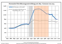
Demography

Development of Population since 1875 within the Current Boundaries (Blue Line: Population; Dotted Line: Comparison to Population Development of Brandenburg state; Grey Background: Time of Nazi rule; Red Background: Time of Communist rule)
Hermsdorf: Population development
within the current boundaries (2013)[3]
YearPop.±% p.a.
1875 400—    
1890 400+0.00%
1910 550+1.61%
1925 593+0.50%
1933 575−0.38%
1939 836+6.44%
1946 1,122+4.29%
1950 1,236+2.45%
1964 1,263+0.15%
1971 1,210−0.61%
1981 1,091−1.03%
1985 1,043−1.12%
1989 1,045+0.05%
1990 1,040−0.48%
1991 1,034−0.58%
1992 1,020−1.35%
1993 1,010−0.98%
1994 1,023+1.29%
1995 1,007−1.56%
1996 1,010+0.30%
YearPop.±% p.a.
1997 1,019+0.89%
1998 1,013−0.59%
1999 1,014+0.10%
2000 1,020+0.59%
2001 1,029+0.88%
2002 952−7.48%
2003 942−1.05%
2004 930−1.27%
2005 924−0.65%
2006 908−1.73%
2007 893−1.65%
2008 874−2.13%
2009 856−2.06%
2010 839−1.99%
2011 813−3.10%
2012 808−0.62%
2013 803−0.62%
2014 795−1.00%
2015 797+0.25%
2016 796−0.13%

References

  1. ^ Landkreis Oberspreewald-Lausitz Wahl der Bürgermeisterin / des Bürgermeisters, accessed 2 July 2021.
  2. ^ "Bevölkerungsentwicklung und Flächen der kreisfreien Städte, Landkreise und Gemeinden im Land Brandenburg 2021" (PDF). Amt für Statistik Berlin-Brandenburg (in German). June 2022.
  3. ^ Detailed data sources are to be found in the Wikimedia Commons.Population Projection Brandenburg at Wikimedia Commons


This page was last edited on 22 October 2022, at 09:38
Basis of this page is in Wikipedia. Text is available under the CC BY-SA 3.0 Unported License. Non-text media are available under their specified licenses. Wikipedia® is a registered trademark of the Wikimedia Foundation, Inc. WIKI 2 is an independent company and has no affiliation with Wikimedia Foundation.