
Hendijan County
Persian: شهرستان هندیجان | |
|---|---|
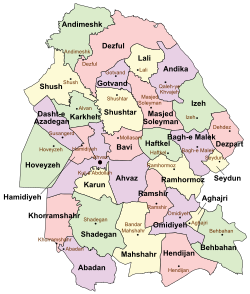 Location of Hendijan County in Khuzestan province (bottom right, pink) | |
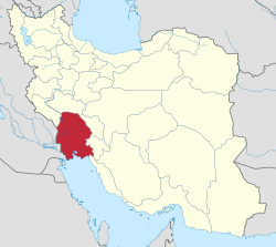 Location of Khuzestan province in Iran | |
| Coordinates: 30°18′N 49°51′E / 30.300°N 49.850°E[1] | |
| Country | |
| Province | Khuzestan |
| Capital | Hendijan |
| Districts | Central, Cham Khalaf-e Isa |
| Population (2016)[2] | |
| • Total | 38,762 |
| Time zone | UTC+3:30 (IRST) |
| Hendijan County can be found at GEOnet Names Server, at this link, by opening the Advanced Search box, entering "9206396" in the "Unique Feature Id" form, and clicking on "Search Database". | |
Hendijan County (Persian: شهرستان هندیجان) is in Khuzestan province, Iran. Its capital is the city of Hendijan.[3]
History
The name of this area was "Hendigan" after Islam entered Iran, because of its vicinity to the Persian Gulf.
According to archaeological documents, this area was a residential area on the edge of Hendijan River around 10,000 years BCE.
Some earthenware also prove civilization in lower part of Hendijan River in the vicinity of the Persian Gulf related to Arsacid Empire era.
Some earthenware famous as Chinese earthenware has been found in the historical harbor called Mahi Rouban in the vicinity of Hendijan related to the Ashkaniyan era.
Demographics
Population
At the time of the 2006 National Census, the county's population was 35,932 in 7,227 households.[4] The following census in 2011 counted 37,440 people in 8,873 households.[5] At the 2016 census, the county's population was 38,762 in 10,636 households.[2] Hendijan County is located in the southeast of Iran and is connected to Persian Gulf through Zohreh River.
Administrative divisions
Hendijan County's population history and administrative structure over three consecutive censuses are shown in the following table.
| Administrative Divisions | 2006[4] | 2011[5] | 2016[2] |
|---|---|---|---|
| Central District | 28,715 | 30,506 | 32,112 |
| Hendijan-e Gharbi RD | 1,136 | 1,313 | 1,165 |
| Hendijan-e Sharqi RD | 2,479 | 2,264 | 1,932 |
| Hendijan (city) | 25,100 | 26,929 | 29,015 |
| Cham Khalaf-e Isa District | 7,217 | 6,934 | 6,650 |
| Cham Khalaf-e Isa RD | 2,701 | 2,693 | 2,524 |
| Soviren RD | 3,234 | 2,964 | 2,934 |
| Zahreh (city) | 1,282 | 1,277 | 1,192 |
| Total | 35,932 | 37,440 | 38,762 |
| RD = Rural District | |||
See also
![]() Media related to Hendijan County at Wikimedia Commons
Media related to Hendijan County at Wikimedia Commons
References
- ^ OpenStreetMap contributors (1 August 2023). "Hendijan County" (Map). OpenStreetMap. Retrieved 1 August 2023.
- ^ a b c "Census of the Islamic Republic of Iran, 1395 (2016)". AMAR (in Persian). The Statistical Center of Iran. p. 06. Archived from the original (Excel) on 21 October 2020. Retrieved 19 December 2022.
- ^ Aref, Mohammad Reza (2 February 1366). "Divisional reforms in Khuzestan province". Laws and Regulations Portal of the Islamic Republic of Iran (in Persian). Ministry of Interior, Political-Defense Commission of the Council of Ministers. Archived from the original on 14 August 2022. Retrieved 26 January 2024.
- ^ a b "Census of the Islamic Republic of Iran, 1385 (2006)". AMAR (in Persian). The Statistical Center of Iran. p. 06. Archived from the original (Excel) on 20 September 2011. Retrieved 25 September 2022.
- ^ a b "Census of the Islamic Republic of Iran, 1390 (2011)". Syracuse University (in Persian). The Statistical Center of Iran. p. 06. Archived from the original (Excel) on 18 January 2023. Retrieved 19 December 2022.

| Capital | |||||||||||||||||||||
|---|---|---|---|---|---|---|---|---|---|---|---|---|---|---|---|---|---|---|---|---|---|
| Districts |
| ||||||||||||||||||||
This Khuzestan province location article is a stub. You can help Wikipedia by expanding it. |